


America’s Next Indoor Snow Centre Takes Shape
Construction of a new indoor snow centre for skiers, boarders and tubers appears to be making good progress at Heritage Farm in Wayne County, West Virginia.

Next 3 days weather summary:Moderate rain (total 10.0mm), heaviest on Tue afternoon. Warm (max 20°C on Thu afternoon, min 13°C on Tue morning). Wind will be generally light. | Days 4-6 weather summary:Light rain (total 6.0mm), mostly falling on Sun morning. Warm (max 22°C on Fri afternoon, min 17°C on Sat night). Winds increasing (calm on Fri afternoon, fresh winds from the NE by Sat night). | |||||||||||||||||
Tuesday 21 | Wednesday 22 | Thursday 23 | Friday 24 | Saturday 25 | Sunday 26 | |||||||||||||
AM | PM | night | AM | PM | night | AM | PM | night | AM | PM | night | AM | PM | night | AM | PM | night | |
t-storm risk | t-storm risk | rain shwrs | clear | t-storm risk | t-storm risk | clear | some clouds | clear | clear | some clouds | clear | clear | t-storm risk | light rain | light rain | clear | some clouds | |
km/h | ||||||||||||||||||
Snow map | 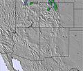 | 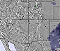 | 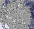 | 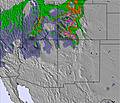 | 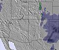 | 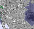 | ||||||||||||
— | — | — | — | — | — | — | — | — | — | — | — | — | — | — | — | — | — | |
mm | 2 | 3 | 2 | — | 1 | 2 | — | — | — | — | — | — | — | 1 | 3 | 2 | — | — |
max °C | 14 | 14 | 14 | 15 | 17 | 17 | 18 | 20 | 20 | 20 | 22 | 22 | 22 | 22 | 19 | 18 | 18 | 18 |
min °C | 13 | 14 | 13 | 14 | 16 | 17 | 17 | 20 | 19 | 20 | 22 | 21 | 21 | 22 | 17 | 18 | 17 | 17 |
chill °C | 12 | 14 | 12 | 14 | 16 | 17 | 17 | 20 | 19 | 20 | 22 | 21 | 21 | 22 | 16 | 18 | 16 | 17 |
Humid % | 76 | 82 | 74 | 71 | 72 | 58 | 55 | 53 | 51 | 44 | 41 | 39 | 39 | 43 | 48 | 55 | 71 | 63 |
Freeze m | 5000 | 5150 | 5250 | 5250 | 5450 | 5450 | 5450 | 5550 | 5550 | 5600 | 5750 | 5700 | 5700 | 5700 | 5600 | 5600 | 5500 | 5450 |
5:30 | — | — | 5:30 | — | — | 5:31 | — | — | 5:31 | — | — | 5:31 | — | — | 5:33 | — | — | |
— | 7:28 | — | — | 7:27 | — | — | 7:27 | — | — | 7:25 | — | — | 7:25 | — | — | 7:24 | — | |
Go pro and carve into:
Avalanche information: National Avalanche Center
Latest snow reports near Mount Lemmon Ski Valley:
| Top snow depth: | — |
|---|---|
| Bottom snow depth: | — |
| Fresh snowfall depth: | — |
| Last snowfall: | 9 Mar 2026 |
| Snow Alerts | Create Alert |
0.0 | Bluebird Powder days Fresh snow, mostly sunny, light wind. |
|---|---|
0.0 | Powder days Fresh snow, limited sun, any wind. |
0.0 | Bluebird days Average snow, mostly sunny, light wind. |
The above table gives the weather forecast for Mount Lemmon Ski Valley at the specific elevation of 2791 m. Our sophisticated weather models allow us to provide snow forecasts for the top, middle and bottom ski stations of Mount Lemmon Ski Valley. To access the weather forecasts for the other elevations, use the tab navigation above the table. For a wider view of the weather, check out the Weather Map of United States.
Click here to read further information on freezing levels and how we forecast our temperatures.
Overall 2.9 Based on 7 votes and 2 reviews
Tried to go up the Catalina Hwy to ski Mt. Lemmon, but the line of cars waiting to go up was huge and would have taken all day. The ski area should have a shuttle for those wanting to ski. It was obvious that a lot of the cars had skiers/snowboarders waiting to go up. Lots of lost business. I turned around and went home.
K from United States writes:
Tried to go up the Catalina Hwy to ski Mt. Lemmon, but the line of cars waiting to go up was huge and would have taken all day. The ski area should have a shuttle for those wanting to ski. It was obvious that a lot of the cars had skiers/snowboarders waiting to go up. Lots of lost business. I turned around and went home.
Read 1 more reviews of Mount Lemmon Ski Valley or submit your own


 Nearest