


Global Weekly Snow Roundup #320
Weekly Snow News for the world, updated 25 June 2026: Chile and New Zealand's seasons proper set to begin, Tignes and Sunshine reopen for summer skiing. weekend as Riksgransen ends its 2026 season.

Next 3 days weather summary:Heavy rain (total 30.0mm), heaviest during Sun afternoon. Very mild (max 18°C on Mon afternoon, min 8°C on Sun night). Wind will be generally light. | Days 4-6 weather summary:Heavy rain (total 28.0mm), heaviest during Tue afternoon. Very mild (max 18°C on Thu afternoon, min 9°C on Wed night). Wind will be generally light. | |||||||||||||||||
Saturday 27 | Sunday 28 | Monday 29 | Tuesday 30 | Wednesday 1 | Thursday 2 | |||||||||||||
AM | PM | night | AM | PM | night | AM | PM | night | AM | PM | night | AM | PM | night | AM | PM | night | |
light rain | light rain | rain shwrs | light rain | mod. rain | mod. rain | rain shwrs | light rain | cloudy | light rain | mod. rain | light rain | light rain | rain shwrs | rain shwrs | light rain | rain shwrs | some clouds | |
km/h | ||||||||||||||||||
Snow map | 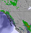 | 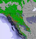 | 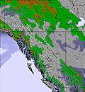 | 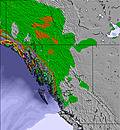 | 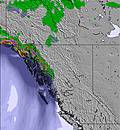 | 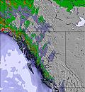 | ||||||||||||
— | — | — | — | — | — | — | — | — | — | — | — | — | — | — | — | — | — | |
mm | 2 | 3 | 6 | 2 | 6 | 9 | 1 | 1 | — | 3 | 9 | 4 | 2 | 2 | 5 | 2 | 1 | — |
max °C | 11 | 14 | 11 | 11 | 10 | 10 | 16 | 18 | 15 | 13 | 12 | 11 | 14 | 16 | 14 | 14 | 18 | 16 |
min °C | 10 | 13 | 9 | 11 | 10 | 8 | 14 | 18 | 12 | 13 | 11 | 10 | 11 | 16 | 9 | 12 | 17 | 11 |
chill °C | 10 | 13 | 8 | 10 | 8 | 6 | 14 | 18 | 12 | 13 | 11 | 10 | 11 | 16 | 9 | 12 | 17 | 11 |
Humid % | 86 | 65 | 84 | 81 | 89 | 96 | 66 | 49 | 66 | 78 | 89 | 93 | 90 | 56 | 73 | 72 | 43 | 47 |
Freeze m | 2900 | 3200 | 3100 | 3150 | 3050 | 3500 | 3400 | 3750 | 3700 | 3400 | 3150 | 3200 | 3150 | 3450 | 3450 | 3150 | 3400 | 3600 |
5:30 | — | — | 5:30 | — | — | 5:31 | — | — | 5:31 | — | — | 5:31 | — | — | 5:33 | — | — | |
— | — | 10:07 | — | — | 10:07 | — | — | 10:07 | — | — | 10:07 | — | — | 10:07 | — | — | 10:07 | |
Go pro and carve into:
Avalanche information: Avalanche Canada
Latest snow reports near Mistaya Lodge:
| Top snow depth: | — |
|---|---|
| Bottom snow depth: | — |
| Fresh snowfall depth: | — |
| Last snowfall: | 12 Jun 2026 |
| Snow Alerts | Create Alert |
0.0 | Bluebird Powder days Fresh snow, mostly sunny, light wind. |
|---|---|
0.0 | Powder days Fresh snow, limited sun, any wind. |
0.0 | Bluebird days Average snow, mostly sunny, light wind. |


The above table gives the weather forecast for Mistaya Lodge at the specific elevation of 1500 m. Our sophisticated weather models allow us to provide snow forecasts for the top, middle and bottom ski stations of Mistaya Lodge. To access the weather forecasts for the other elevations, use the tab navigation above the table. For a wider view of the weather, check out the Weather Map of Canada.
Click here to read further information on freezing levels and how we forecast our temperatures.
Overall 4.9 Based on 2 votes and 2 reviews
Mistaya Lodge has great skiing terrain, long glacier runs, steep to moderate glades and excellent food served at the lodge. It's a wonderful spot tucked away in the Rockies. Very remote so you're not going to hear or see anyone else, no sleds and heli-skiers here. The ski runs top out at 3000m and 1800m on the low end at Mistaya Lodge.
Dean Thompson from Canada writes:
Mistaya Lodge has great skiing terrain, long glacier runs, steep to moderate glades and excellent food served at the lodge. It's a wonderful spot tucked away in the Rockies. Very remote so you're not going to hear or see anyone else, no sleds and heli-skiers here. The ski runs top out at 3000m and 1800m on the low end at Mistaya Lodge.


 Nearest