


Global Weekly Snow Roundup #320
Weekly Snow News for the world, updated 25 June 2026: Chile and New Zealand's seasons proper set to begin, Tignes and Sunshine reopen for summer skiing. weekend as Riksgransen ends its 2026 season.

Next 3 days weather summary:Heavy rain (total 20.0mm), heaviest during Sun night. Warm (max 30°C on Sat afternoon, min 14°C on Mon night). Wind will be generally light. | Days 4-6 weather summary:Mostly dry. Warm (max 24°C on Tue afternoon, min 11°C on Wed night). Mainly fresh winds. | |||||||||||||||||
Saturday 27 | Sunday 28 | Monday 29 | Tuesday 30 | Wednesday 1 | Thursday 2 | |||||||||||||
AM | PM | night | AM | PM | night | AM | PM | night | AM | PM | night | AM | PM | night | AM | PM | night | |
clear | clear | rain shwrs | rain shwrs | clear | rain shwrs | some clouds | t-storm risk | rain shwrs | clear | clear | some clouds | some clouds | some clouds | some clouds | clear | clear | clear | |
km/h | ||||||||||||||||||
Snow map | 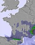 | 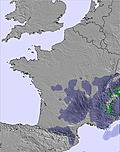 |  |  |  |  | ||||||||||||
— | — | — | — | — | — | — | — | — | — | — | — | — | — | — | — | — | — | |
mm | — | — | 2 | 1 | — | 12 | — | 3 | 2 | — | — | — | — | — | — | — | — | — |
max °C | 27 | 30 | 27 | 24 | 28 | 23 | 18 | 19 | 18 | 20 | 24 | 23 | 17 | 20 | 18 | 17 | 22 | 21 |
min °C | 22 | 29 | 17 | 18 | 28 | 15 | 15 | 19 | 14 | 16 | 23 | 13 | 15 | 19 | 11 | 14 | 20 | 13 |
chill °C | 22 | 29 | 17 | 18 | 28 | 14 | 15 | 19 | 13 | 15 | 23 | 12 | 14 | 19 | 8 | 12 | 20 | 11 |
Humid % | 26 | 23 | 55 | 58 | 31 | 78 | 89 | 75 | 72 | 55 | 34 | 48 | 51 | 33 | 50 | 54 | 38 | 44 |
Freeze m | 4600 | 4600 | 4500 | 4450 | 4500 | 4200 | 4150 | 4150 | 4250 | 4150 | 4000 | 4000 | 3850 | 3800 | 4400 | 4400 | 4400 | 4300 |
6:01 | — | — | 6:01 | — | — | 6:01 | — | — | 6:01 | — | — | 6:03 | — | — | 6:03 | — | — | |
— | — | 9:40 | — | — | 9:40 | — | — | 9:40 | — | — | 9:40 | — | — | 9:40 | — | — | 9:40 | |
Go pro and carve into:
Avalanche information: European Avalanche Warning Services (EAWS)
Latest snow reports near Le Mont-Dore:
| Top snow depth: | 0 cm |
|---|---|
| Bottom snow depth: | 0 cm |
| Fresh snowfall depth: | — |
| Last snowfall: | 16 May 2026 |
| Snow Alerts | Create Alert |
0.0 | Bluebird Powder days Fresh snow, mostly sunny, light wind. |
|---|---|
0.0 | Powder days Fresh snow, limited sun, any wind. |
0.0 | Bluebird days Average snow, mostly sunny, light wind. |
The above table gives the weather forecast for Le Mont-Dore at the specific elevation of 1204 m. Our sophisticated weather models allow us to provide snow forecasts for the top, middle and bottom ski stations of Le Mont-Dore. To access the weather forecasts for the other elevations, use the tab navigation above the table. For a wider view of the weather, check out the Weather Map of France.
Click here to read further information on freezing levels and how we forecast our temperatures.
Overall 3.8 Based on 17 votes and 3 reviews
There is some really good skiing to be had here (Le Mont-Dore) and now the link with Super Besse is open there is some 90 kms of skiing. There is a panoramic restaurant at the top of the telecabine, food is reasonable but the whole place needs renovation. There is also a restaurant at the bottom of the chair lift. When you cross over to Super Besse you will be surprised at the extent of the skiing available. There are plenty of restaurants and bars here all offering a good variety of tucker. Overall, one of the most interesting and unknown ski resorts to the British public (6 day ski pass - 145 Euros, Meribel by comparison is 225 Euros, but of course you have access to the largest ski domain in the world).
Chris Turner from France writes:
There is some really good skiing to be had here (Le Mont-Dore) and now the link with Super Besse is open there is some 90 kms of skiing.
There is a panoramic restaurant at the top of the telecabine, food is reasonable but the whole place needs renovation. There is also a restaurant at the bottom of the chair lift. When you cross over to Super Besse you will be surprised at the extent of the skiing available. There are plenty of restaurants and bars here all offering a good variety of tucker.
Overall, one of the most interesting and unknown ski resorts to the British public (6 day ski pass - 145 Euros, Meribel by comparison is 225 Euros, but of course you have access to the largest ski domain in the world).


 Nearest