

Global Weekly Snow Roundup #322
Weekly Global Snow News, updated 8 July 2026: New Zealand leads with 80cm (32”) snowfall, while Australia and the Andes improve as Northern Hemisphere summer skiing declines.

Next 3 days weather summary:Moderate rain (total 12.0mm), heaviest on Thu night. Warm (max 20°C on Fri afternoon, min 12°C on Fri night). Wind will be generally light. | Days 4-6 weather summary:Light rain (total 4.0mm), mostly falling on Tue afternoon. Warm (max 21°C on Sun afternoon, min 11°C on Tue night). Winds increasing (calm on Sun night, strong winds from the W by Mon night). | |||||||||||||||||
Thursday 9 | Friday 10 | Saturday 11 | Sunday 12 | Monday 13 | Tuesday 14 | |||||||||||||
AM | PM | night | AM | PM | night | AM | PM | night | AM | PM | night | AM | PM | night | AM | PM | night | |
light rain | light rain | mod. rain | rain shwrs | some clouds | clear | some clouds | some clouds | clear | clear | clear | clear | clear | clear | some clouds | cloudy | t-storm risk | rain shwrs | |
km/h | ||||||||||||||||||
Snow map | 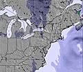 | 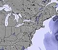 | 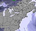 | 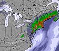 | 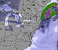 | 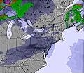 | ||||||||||||
— | — | — | — | — | — | — | — | — | — | — | — | — | — | — | — | — | — | |
mm | 2 | 2 | 6 | 2 | — | — | — | — | — | — | — | — | — | — | — | — | 3 | 1 |
max °C | 17 | 19 | 17 | 18 | 20 | 17 | 16 | 17 | 14 | 18 | 21 | 18 | 19 | 21 | 20 | 19 | 18 | 17 |
min °C | 16 | 18 | 15 | 16 | 18 | 12 | 14 | 16 | 12 | 16 | 20 | 14 | 16 | 21 | 19 | 19 | 17 | 11 |
chill °C | 15 | 18 | 15 | 15 | 18 | 11 | 14 | 15 | 11 | 16 | 20 | 13 | 15 | 21 | 19 | 18 | 15 | 8 |
Humid % | 90 | 79 | 92 | 54 | 56 | 58 | 56 | 55 | 60 | 46 | 40 | 64 | 50 | 58 | 62 | 84 | 93 | 69 |
Freeze m | 3900 | 3900 | 3650 | 3150 | 3050 | 2900 | 2900 | 3100 | 3000 | 3150 | 3100 | 3400 | 3950 | 4150 | 4650 | 4200 | 3800 | 3050 |
4:56 | — | — | 4:58 | — | — | 4:58 | — | — | 5:00 | — | — | 5:01 | — | — | 5:01 | — | — | |
— | — | 8:36 | — | — | 8:35 | — | — | 8:34 | — | — | 8:34 | — | — | 8:32 | — | — | 8:31 | |
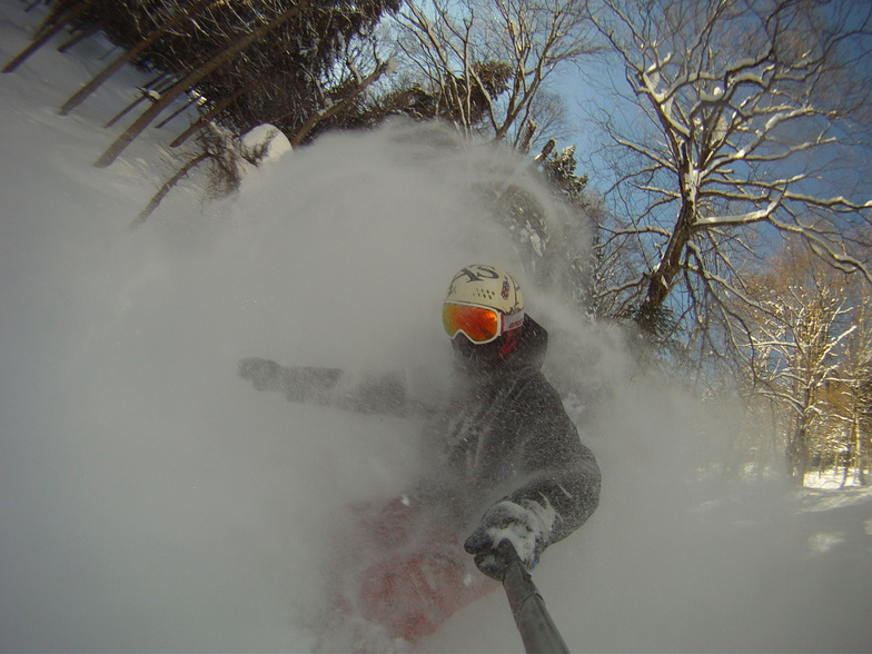
Go pro and carve into:
Avalanche information: Avalanche Canada
Latest snow reports near Le Massif du Sud:
| Top snow depth: | — |
|---|---|
| Bottom snow depth: | — |
| Fresh snowfall depth: | — |
| Last snowfall: | 4 May 2026 |
| Snow Alerts | Create Alert |
0.0 | Bluebird Powder days Fresh snow, mostly sunny, light wind. |
|---|---|
0.0 | Powder days Fresh snow, limited sun, any wind. |
0.0 | Bluebird days Average snow, mostly sunny, light wind. |

The above table gives the weather forecast for Le Massif du Sud at the specific elevation of 714 m. Our sophisticated weather models allow us to provide snow forecasts for the top, middle and bottom ski stations of Le Massif du Sud. To access the weather forecasts for the other elevations, use the tab navigation above the table. For a wider view of the weather, check out the Weather Map of Canada.
Click here to read further information on freezing levels and how we forecast our temperatures.


 Nearest