

Global Weekly Snow Roundup #322
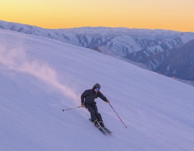
Weekly Global Snow News, updated 8 July 2026: New Zealand leads with 80cm (32”) snowfall, while Australia and the Andes improve as Northern Hemisphere summer skiing declines.

Next 3 days weather summary:Light rain (total 6.0mm), mostly falling on Fri night. Very mild (max 14°C on Fri afternoon, min 9°C on Sat morning). Wind will be generally light. | Days 4-6 weather summary:Light rain (total 6.0mm), mostly falling on Mon night. Very mild (max 14°C on Mon afternoon, min 9°C on Mon night). Wind will be generally light. | |||||||||||||||||
Friday 10 | Saturday 11 | Sunday 12 | Monday 13 | Tuesday 14 | Wednesday 15 | |||||||||||||
AM | PM | night | AM | PM | night | AM | PM | night | AM | PM | night | AM | PM | night | AM | PM | night | |
clear | some clouds | rain shwrs | some clouds | clear | rain shwrs | clear | clear | some clouds | clear | some clouds | rain shwrs | t-storm risk | clear | clear | clear | clear | clear | |
km/h | ||||||||||||||||||
Snow map |  |  |  |  |  |  | ||||||||||||
— | — | — | — | — | — | — | — | — | — | — | — | — | — | — | — | — | — | |
mm | — | — | 4 | — | — | 2 | — | — | — | — | — | 4 | 2 | — | — | — | — | — |
max °C | 11 | 14 | 11 | 10 | 13 | 10 | 10 | 13 | 11 | 12 | 14 | 12 | 11 | 13 | 11 | 12 | 14 | 13 |
min °C | 10 | 13 | 10 | 9 | 12 | 9 | 9 | 12 | 10 | 11 | 14 | 9 | 9 | 13 | 9 | 10 | 14 | 12 |
chill °C | 10 | 13 | 10 | 8 | 11 | 9 | 8 | 12 | 10 | 11 | 13 | 8 | 8 | 12 | 7 | 9 | 13 | 12 |
Humid % | 50 | 47 | 58 | 73 | 49 | 43 | 34 | 43 | 48 | 44 | 44 | 65 | 59 | 42 | 54 | 49 | 40 | 47 |
Freeze m | 4200 | 4450 | 4250 | 4000 | 4350 | 4200 | 4150 | 4350 | 4250 | 4250 | 4500 | 4200 | 4150 | 4400 | 4200 | 4300 | 4550 | 4500 |
5:31 | — | — | 5:31 | — | — | 5:33 | — | — | 5:33 | — | — | 5:35 | — | — | 5:35 | — | — | |
— | — | 9:12 | — | — | 9:10 | — | — | 9:10 | — | — | 9:09 | — | — | 9:08 | — | — | 9:07 | |
Go pro and carve into:
Avalanche information: European Avalanche Warning Services (EAWS)
Latest snow reports near Kaunertal:
| Top snow depth: | 0 cm |
|---|---|
| Bottom snow depth: | 0 cm |
| Fresh snowfall depth: | — |
| Last snowfall: | 12 Jun 2026 |
| Snow Alerts | Create Alert |
0.0 | Bluebird Powder days Fresh snow, mostly sunny, light wind. |
|---|---|
0.2 | Powder days Fresh snow, limited sun, any wind. |
0.0 | Bluebird days Average snow, mostly sunny, light wind. |
The above table gives the weather forecast for Kaunertal at the specific elevation of 2692 m. Our sophisticated weather models allow us to provide snow forecasts for the top, middle and bottom ski stations of Kaunertal. To access the weather forecasts for the other elevations, use the tab navigation above the table. For a wider view of the weather, check out the Weather Map of Austria.
Click here to read further information on freezing levels and how we forecast our temperatures.
Overall 3.9 Based on 17 votes and 2 reviews
Awesome place, great crowd-free pistes and some off piste action. Drive up would get boring after a week but amazing, especially in avalanche season! Real high mountain feel, go for a pizza at Andreas's in Feichten on way back. Reasonable prices, you can always go to Fendels for a change.
Jon+Tom from Ireland writes:
Awesome place, great crowd-free pistes and some off piste action. Drive up would get boring after a week but amazing, especially in avalanche season! Real high mountain feel, go for a pizza at Andreas's in Feichten on way back.
Reasonable prices, you can always go to Fendels for a change.


 Nearest