
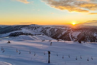
Australia Set for 60cm Storm Surge as July Snow Begins
Updated 9th July 2025: Snow dumps hit Argentina, Cardrona unveils NZ’s biggest ski area, and Aussie resorts brace for 2 feet (60cm) more—click for full breakdown!
By using Snow-Forecast, you agree to our Terms & Services.
Don't have an account? Join now
Alternatively, you can now use your Outside account to sign in to any brand in the Outside digital ecosystem, including Snow-Forecast, Surf-Forecast, and Mountain-Forecast.


Damüls Weather (Next 3 days): The snow forecast for Damüls is: Light rain (total 5.0mm), mostly falling on Fri afternoon. Very mild (max 18°C on Sat afternoon, min 9°C on Thu morning). Wind will be generally light.
Damüls Weather (Days 4-6): Heavy rain (total 34.0mm), heaviest during Tue night. Warm (max 22°C on Mon afternoon, min 13°C on Tue night). Wind will be generally light.
| Resort | Snow Depth | Temp. (°C) | Wind (km/h) | Weather | ||
|---|---|---|---|---|---|---|
| Top Lift: | 0.0 m | 5 | ||||
| Middle Lift: | 9 | |||||
| Bottom Lift: | 0.0 m | 9 |
Latest snow reports near Damüls:

Thursday 10 | Friday 11 | Saturday 12 | Sunday 13 | Monday 14 | Tuesday 15 | Wednesday 16 | |||||||||||||||
AM | PM | night | AM | PM | night | AM | PM | night | AM | PM | night | AM | PM | night | AM | PM | night | AM | PM | night | |
clear | clear | clear | some clouds | rain shwrs | rain shwrs | clear | clear | rain shwrs | risk thun- der | risk thun- der | rain shwrs | some clouds | rain shwrs | rain shwrs | some clouds | risk thun- der | rain shwrs | rain shwrs | some clouds | clear | |
km/h | |||||||||||||||||||||
Snow map |  |  |  |  |  |  |  | ||||||||||||||
— | — | — | — | — | — | — | — | — | — | — | — | — | — | — | — | — | — | — | — | — | |
— | — | — | — | 1 | 2 | — | — | 2 | 2 | 3 | 7 | — | 1 | 2 | — | 3 | 16 | 2 | — | — | |
max°C | 12 | 15 | 13 | 14 | 16 | 14 | 15 | 18 | 16 | 18 | 19 | 17 | 20 | 22 | 19 | 20 | 20 | 17 | 16 | 18 | 17 |
min°C | 9 | 14 | 11 | 12 | 16 | 12 | 13 | 17 | 14 | 15 | 17 | 15 | 18 | 20 | 18 | 19 | 19 | 13 | 15 | 18 | 15 |
9 | 14 | 11 | 12 | 16 | 12 | 13 | 17 | 14 | 15 | 17 | 14 | 18 | 20 | 18 | 19 | 19 | 13 | 15 | 18 | 15 | |
55 | 48 | 66 | 53 | 52 | 58 | 55 | 51 | 65 | 58 | 65 | 58 | 44 | 39 | 52 | 47 | 58 | 85 | 71 | 56 | 62 | |
3200 | 3100 | 3200 | 3100 | 3200 | 3100 | 3250 | 3500 | 3650 | 3600 | 3750 | 3650 | 3650 | 3900 | 3900 | 3850 | 3950 | 3700 | 3750 | 3850 | 4150 | |
5:33 | — | — | 5:35 | — | — | 5:35 | — | — | 5:37 | — | — | 5:37 | — | — | 5:37 | — | — | 5:39 | — | — | |
— | — | 9:15 | — | — | 9:15 | — | — | 9:15 | — | — | 9:14 | — | — | 9:14 | — | — | 9:13 | — | — | 9:12 | |
Light rain (total 5.0mm), mostly falling on Fri afternoon. Very mild (max 18°C on Sat afternoon, min 9°C on Thu morning). Wind will be generally light.
Heavy rain (total 34.0mm), heaviest during Tue night. Warm (max 22°C on Mon afternoon, min 13°C on Tue night). Wind will be generally light.
Latest snow reports near Damüls:
| Top snow depth: | 0 cm |
|---|---|
| Bottom snow depth: | 0 cm |
| Fresh snowfall depth: | — |
| Last snowfall: | 5 May 2025 |
| Snow Alerts | Create Alert |
0.0 | Bluebird Powder days Fresh snow, mostly sunny, light wind. |
|---|---|
0.0 | Powder days Fresh snow, limited sun, any wind. |
0.0 | Bluebird days Average snow, mostly sunny, light wind. |


The above table gives the weather forecast for Damüls at the specific elevation of 1339 m. Our sophisticated weather models allow us to provide snow forecasts for the top, middle and bottom ski stations of Damüls. To access the weather forecasts for the other elevations, use the tab navigation above the table. For a wider view of the weather, check out the Weather Map of Austria.
Click here to read further information on freezing levels and how we forecast our temperatures.
Resort name is also written as Damuls.
Overall 4.7 Based on 3 votes and 2 reviews
Excelente centro de ski, muchisima nieve en polvo. Pistas en muy buenas condiciones, realmente para recomendar, y con precios muy accesibles. Hoy es mi ultimo dia y me voy con un excelente recuerdo de este lugar.
hernan from Argentina writes:
Excelente centro de ski, muchisima nieve en polvo. Pistas en muy buenas condiciones, realmente para recomendar, y con precios muy accesibles.
Hoy es mi ultimo dia y me voy con un excelente recuerdo de este lugar.
The Damüls skiing weather widget is available to embed on external websites free of charge. It provides a daily summary of our Damüls snow forecast and current weather conditions. Simply go to the feed configuration page and follow the 3 simple steps to grab the custom html code snippet and paste it into your own site. You can choose the snow forecast elevation (summit, mid-mountain or bottom lift) and metric/imperial units for the snow forecast feed to suit your own website…. Click here to get the code.
View detailed snow forecast for Damüls at:
snow-forecast.com


 Nearest