

A New Largest Ski Area in New Zealand?
The Remarkables is hoping to overtake Cardrona as New Zealand’s largest ski area under a major NZD 150 million‑plus expansion proposal lodged by owner NZSki.

Next 4 days weather summary:Moderate rain (total 12.0mm), heaviest on Fri night. Very mild (max 19°C on Wed night, min 7°C on Thu night). Wind will be generally light. | Days 5-7 weather summary:Light rain (total 9.0mm), mostly falling on Sun morning. Very mild (max 15°C on Sun afternoon, min 9°C on Sat night). Wind will be generally light. | |||||||||||||||
Thursday 25 | Friday 26 | Saturday 27 | Sunday 28 | Monday 29 | ||||||||||||
night | AM | PM | night | AM | PM | night | AM | PM | night | AM | PM | night | AM | PM | night | |
some clouds | cloudy | cloudy | light rain | light rain | light rain | light rain | cloudy | cloudy | cloudy | light rain | light rain | light rain | cloudy | cloudy | light rain | |
km/h | ||||||||||||||||
Snow map | 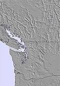 |  | 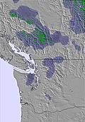 | 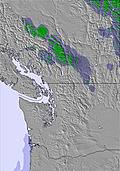 | 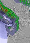 | 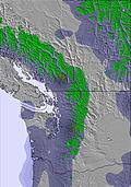 | ||||||||||
— | — | — | — | — | — | — | — | — | — | — | — | — | — | — | — | |
mm | — | — | — | 4 | 2 | 2 | 4 | — | — | — | 1 | 2 | 1 | — | — | 1 |
max °C | 19 | 18 | 17 | 12 | 8 | 11 | 9 | 13 | 14 | 14 | 14 | 15 | 12 | 12 | 14 | 12 |
min °C | 10 | 14 | 14 | 7 | 8 | 9 | 7 | 8 | 14 | 9 | 10 | 14 | 9 | 10 | 14 | 9 |
chill °C | 10 | 14 | 13 | 6 | 8 | 8 | 7 | 8 | 14 | 9 | 10 | 14 | 9 | 10 | 14 | 8 |
Humid % | 61 | 32 | 53 | 84 | 87 | 73 | 90 | 61 | 56 | 86 | 70 | 66 | 95 | 84 | 71 | 96 |
Freeze m | 3350 | 3150 | 2750 | 2450 | 2450 | 2500 | 2300 | 2650 | 2800 | 2750 | 2800 | 3000 | 2900 | 3250 | 3300 | 2900 |
— | 5:01 | — | — | 5:01 | — | — | 5:01 | — | — | 5:01 | — | — | 5:03 | — | — | |
— | — | — | 9:24 | — | — | 9:24 | — | — | 9:24 | — | — | 9:24 | — | — | 9:24 | |
Go pro and carve into:
Avalanche information: Avalanche Canada
Latest snow reports near Coast Range Heliskiing:
| Top snow depth: | — |
|---|---|
| Bottom snow depth: | — |
| Fresh snowfall depth: | — |
| Last snowfall: | 9 Jun 2026 |
| Snow Alerts | Create Alert |
0.0 | Bluebird Powder days Fresh snow, mostly sunny, light wind. |
|---|---|
0.0 | Powder days Fresh snow, limited sun, any wind. |
0.0 | Bluebird days Average snow, mostly sunny, light wind. |
The above table gives the weather forecast for Coast Range Heliskiing at the specific elevation of 1090 m. Our sophisticated weather models allow us to provide snow forecasts for the top, middle and bottom ski stations of Coast Range Heliskiing. To access the weather forecasts for the other elevations, use the tab navigation above the table. For a wider view of the weather, check out the Weather Map of Canada.
Click here to read further information on freezing levels and how we forecast our temperatures.


 Nearest