

Portillo Re-Opens To Guests Arriving By Helicopter
Chile’s famous Portillo ski resort is reported to have re-opened to guests arriving by helicopter after being cut off by road for more than two weeks by over 6m/20 feet of snowfall.

Next 3 days weather summary:Moderate rain (total 14.0mm), heaviest on Tue night. Very mild (max 19°C on Mon afternoon, min 12°C on Tue night). Wind will be generally light. | Days 4-6 weather summary:Light rain (total 5.0mm), mostly falling on Thu afternoon. Very mild (max 16°C on Sat afternoon, min 11°C on Thu night). Wind will be generally light. | ||||||||||||||||
Mon 3 | Tuesday 4 | Wednesday 5 | Thursday 6 | Friday 7 | Saturday 8 | ||||||||||||
PM | night | AM | PM | night | AM | PM | night | AM | PM | night | AM | PM | night | AM | PM | night | |
clear | rain shwrs | clear | cloudy | rain shwrs | clear | rain shwrs | clear | some clouds | t-storm risk | rain shwrs | clear | clear | clear | clear | clear | clear | |
km/h | |||||||||||||||||
Snow map |  |  |  |  |  |  | |||||||||||
— | — | — | — | — | — | — | — | — | — | — | — | — | — | — | — | — | |
mm | — | 2 | — | — | 11 | — | 1 | — | — | 4 | 1 | — | — | — | — | — | — |
max °C | 19 | 17 | 15 | 16 | 13 | 14 | 16 | 16 | 14 | 13 | 12 | 12 | 14 | 14 | 14 | 16 | 15 |
min °C | 19 | 14 | 15 | 16 | 12 | 13 | 16 | 14 | 14 | 12 | 11 | 11 | 14 | 13 | 12 | 15 | 14 |
chill °C | 19 | 13 | 14 | 16 | 11 | 13 | 16 | 14 | 14 | 12 | 9 | 10 | 14 | 13 | 12 | 15 | 14 |
Humid % | 44 | 58 | 57 | 66 | 61 | 58 | 61 | 53 | 63 | 77 | 67 | 60 | 52 | 45 | 40 | 35 | 37 |
Freeze m | 4700 | 4500 | 4400 | 4350 | 4450 | 4350 | 4450 | 4450 | 4400 | 4400 | 4350 | 4350 | 4400 | 4450 | 4500 | 4550 | 4600 |
— | — | 6:24 | — | — | 6:24 | — | — | 6:26 | — | — | 6:26 | — | — | 6:28 | — | — | |
— | 9:00 | — | — | 9:00 | — | — | 8:59 | — | — | 8:57 | — | — | 8:55 | — | — | 8:53 | |
Go pro and carve into:
Avalanche information: European Avalanche Warning Services (EAWS)
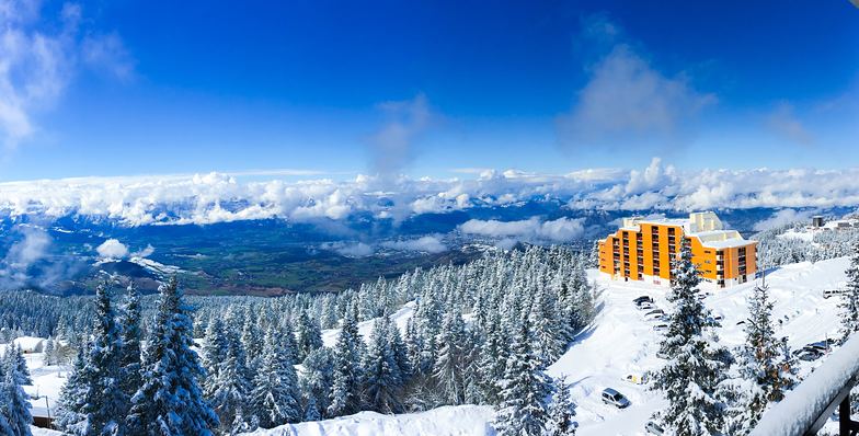
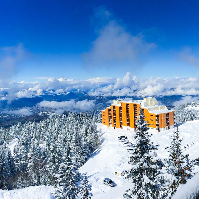
Latest snow reports near Chamrousse:
| Top snow depth: | 0 cm |
|---|---|
| Bottom snow depth: | 0 cm |
| Fresh snowfall depth: | — |
| Last snowfall: | 15 May 2026 |
| Snow Alerts | Create Alert |
0.0 | Bluebird Powder days Fresh snow, mostly sunny, light wind. |
|---|---|
0.0 | Powder days Fresh snow, limited sun, any wind. |
0.0 | Bluebird days Average snow, mostly sunny, light wind. |
The above table gives the weather forecast for Chamrousse at the specific elevation of 2256 m. Our sophisticated weather models allow us to provide snow forecasts for the top, middle and bottom ski stations of Chamrousse. To access the weather forecasts for the other elevations, use the tab navigation above the table. For a wider view of the weather, check out the Weather Map of France.
Click here to read further information on freezing levels and how we forecast our temperatures.
Overall 3.7 Based on 34 votes and 14 reviews
We were here for a week (we returned yesterday). We are not going here again. Our apartment (Domaine de l'Arselle) was really small; for a family with two children we get 1 bedroom and a kitchen with convertible couch (usually we get a bedroom and bunk for two child). Rooms were really small and it didn't have a balcony. Skiing is great, but that's in all the places in France where we were (Alpa d'Houze, Puy St. Vincent). We were there for the second time and we had (again) problems with employees. We always clean the apartment after ourselves and we never had problems anywhere. In Chamrousse they had a problem three years ago; we lost a hanger. They wanted 10 Euros and when they came to take back their keys from the room they wanted stupid things to clean, like mop under cabinets (which no one did in at least 5 years). This year they said the room wasn't clean enough. Okay, they had to clean it. If we would have ordered them to clean it it would have cost us 32 Euros. We expected that they are going to want about 40 Euros. They wanted 80 Euros. We have never ever had this problem anywhere else.
Barbora from Czechia writes:
We were here for a week (we returned yesterday). We are not going here again. Our apartment (Domaine de l'Arselle) was really small; for a family with two children we get 1 bedroom and a kitchen with convertible couch (usually we get a bedroom and bunk for two child). Rooms were really small and it didn't have a balcony. Skiing is great, but that's in all the places in France where we were (Alpa d'Houze, Puy St. Vincent).
We were there for the second time and we had (again) problems with employees. We always clean the apartment after ourselves and we never had problems anywhere. In Chamrousse they had a problem three years ago; we lost a hanger. They wanted 10 Euros and when they came to take back their keys from the room they wanted stupid things to clean, like mop under cabinets (which no one did in at least 5 years). This year they said the room wasn't clean enough. Okay, they had to clean it. If we would have ordered them to clean it it would have cost us 32 Euros. We expected that they are going to want about 40 Euros. They wanted 80 Euros. We have never ever had this problem anywhere else.


 Nearest