

Global Weekly Snow Roundup #322
Weekly Global Snow News, updated 8 July 2026: New Zealand leads with 80cm (32”) snowfall, while Australia and the Andes improve as Northern Hemisphere summer skiing declines.

Next 4 days weather summary:Light rain (total 8.0mm), mostly falling on Thu night. Warm (max 25°C on Fri afternoon, min 15°C on Sat night). Wind will be generally light. | Days 5-7 weather summary:Light rain (total 2.0mm), mostly falling on Tue night. Warm (max 30°C on Tue afternoon, min 16°C on Sun night). Wind will be generally light. | |||||||||||||||
Friday 10 | Saturday 11 | Sunday 12 | Monday 13 | Tuesday 14 | ||||||||||||
night | AM | PM | night | AM | PM | night | AM | PM | night | AM | PM | night | AM | PM | night | |
rain shwrs | clear | clear | rain shwrs | some clouds | clear | clear | clear | clear | clear | clear | clear | clear | clear | clear | rain shwrs | |
km/h | ||||||||||||||||
Snow map | 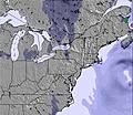 | 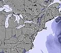 | 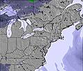 | 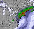 | 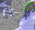 | 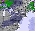 | ||||||||||
— | — | — | — | — | — | — | — | — | — | — | — | — | — | — | — | |
mm | 7 | — | — | 1 | — | — | — | — | — | — | — | — | — | — | — | 1 |
max °C | 19 | 23 | 25 | 21 | 22 | 25 | 21 | 23 | 23 | 20 | 23 | 27 | 24 | 27 | 30 | 26 |
min °C | 17 | 19 | 24 | 17 | 19 | 25 | 15 | 18 | 23 | 16 | 20 | 26 | 19 | 21 | 29 | 21 |
chill °C | 17 | 19 | 24 | 17 | 19 | 25 | 15 | 18 | 23 | 16 | 20 | 26 | 19 | 21 | 29 | 21 |
Humid % | 94 | 61 | 63 | 73 | 56 | 45 | 65 | 49 | 53 | 53 | 48 | 40 | 61 | 50 | 44 | 74 |
Freeze m | 4050 | 3850 | 3850 | 3550 | 3550 | 3750 | 3750 | 4000 | 4050 | 4150 | 4500 | 4600 | 5000 | 5100 | 5050 | 4550 |
— | 5:41 | — | — | 5:41 | — | — | 5:41 | — | — | 5:43 | — | — | 5:43 | — | — | |
— | — | — | 8:57 | — | — | 8:57 | — | — | 8:55 | — | — | 8:55 | — | — | 8:54 | |
Go pro and carve into:
Avalanche information: Avalanche Canada
Latest snow reports near Brimacombe:
| Top snow depth: | — |
|---|---|
| Bottom snow depth: | — |
| Fresh snowfall depth: | — |
| Last snowfall: | 6 Apr 2026 |
| Snow Alerts | Create Alert |
0.0 | Bluebird Powder days Fresh snow, mostly sunny, light wind. |
|---|---|
0.0 | Powder days Fresh snow, limited sun, any wind. |
0.0 | Bluebird days Average snow, mostly sunny, light wind. |
The above table gives the weather forecast for Brimacombe at the specific elevation of 220 m. Our sophisticated weather models allow us to provide snow forecasts for the top, middle and bottom ski stations of Brimacombe. To access the weather forecasts for the other elevations, use the tab navigation above the table. For a wider view of the weather, check out the Weather Map of Canada.
Click here to read further information on freezing levels and how we forecast our temperatures.


 Nearest