

Portillo Storm Snowfall Total Passes 5m / 17 Feet
A snow storm that has now continued for nine days has taken Chilean ski resort Portillo to a snowfall total of 5.2 metres (17 feet) so far, with more snow forecast.

Next 3 days weather summary:Light rain (total 7.0mm), mostly falling on Fri night. Warm (max 30°C on Thu afternoon, min 16°C on Fri night). Wind will be generally light. | Days 4-6 weather summary:Moderate rain (total 16.0mm), heaviest on Mon night. Warm (max 29°C on Sun afternoon, min 15°C on Tue night). Wind will be generally light. | |||||||||||||||||
Thursday 30 | Friday 31 | Saturday 1 | Sunday 2 | Monday 3 | Tuesday 4 | |||||||||||||
AM | PM | night | AM | PM | night | AM | PM | night | AM | PM | night | AM | PM | night | AM | PM | night | |
clear | clear | rain shwrs | clear | cloudy | rain shwrs | clear | some clouds | clear | clear | cloudy | some clouds | t-storm risk | t-storm risk | rain shwrs | t-storm risk | light rain | rain shwrs | |
km/h | ||||||||||||||||||
Snow map |  |  |  |  |  |  | ||||||||||||
— | — | — | — | — | — | — | — | — | — | — | — | — | — | — | — | — | — | |
mm | — | — | 1 | — | — | 6 | — | — | — | — | — | — | 1 | 2 | 6 | 2 | 3 | 2 |
max °C | 27 | 30 | 26 | 28 | 30 | 25 | 26 | 29 | 24 | 27 | 29 | 24 | 25 | 27 | 20 | 24 | 27 | 21 |
min °C | 20 | 30 | 18 | 21 | 29 | 16 | 19 | 28 | 16 | 20 | 25 | 18 | 20 | 26 | 16 | 18 | 21 | 15 |
chill °C | 20 | 30 | 18 | 21 | 29 | 16 | 19 | 28 | 16 | 20 | 25 | 18 | 20 | 26 | 16 | 18 | 21 | 15 |
Humid % | 28 | 21 | 58 | 31 | 33 | 83 | 38 | 27 | 52 | 26 | 39 | 60 | 49 | 46 | 75 | 47 | 68 | 76 |
Freeze m | 4550 | 4850 | 4750 | 4700 | 4800 | 4350 | 4450 | 4750 | 4600 | 4550 | 4700 | 4550 | 4500 | 4650 | 4450 | 4300 | 4400 | 4400 |
6:16 | — | — | 6:16 | — | — | 6:18 | — | — | 6:18 | — | — | 6:20 | — | — | 6:20 | — | — | |
— | — | 9:02 | — | — | 9:00 | — | — | 9:00 | — | — | 8:59 | — | — | 8:58 | — | — | 8:55 | |
Go pro and carve into:
Avalanche information: European Avalanche Warning Services (EAWS)
Latest snow reports near Briancon:
| Top snow depth: | — |
|---|---|
| Bottom snow depth: | — |
| Fresh snowfall depth: | — |
| Last snowfall: | 15 May 2026 |
| Snow Alerts | Create Alert |
0.0 | Bluebird Powder days Fresh snow, mostly sunny, light wind. |
|---|---|
0.0 | Powder days Fresh snow, limited sun, any wind. |
0.0 | Bluebird days Average snow, mostly sunny, light wind. |
The above table gives the weather forecast for Briancon at the specific elevation of 1200 m. Our sophisticated weather models allow us to provide snow forecasts for the top, middle and bottom ski stations of Briancon. To access the weather forecasts for the other elevations, use the tab navigation above the table. For a wider view of the weather, check out the Weather Map of France.
Click here to read further information on freezing levels and how we forecast our temperatures.
Overall 4.2 Based on 9 votes and 1 review
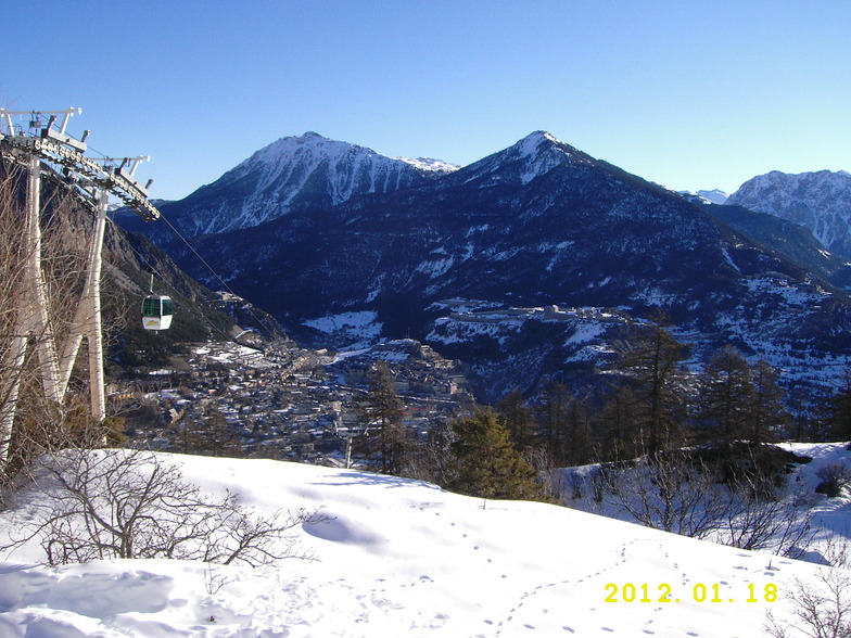
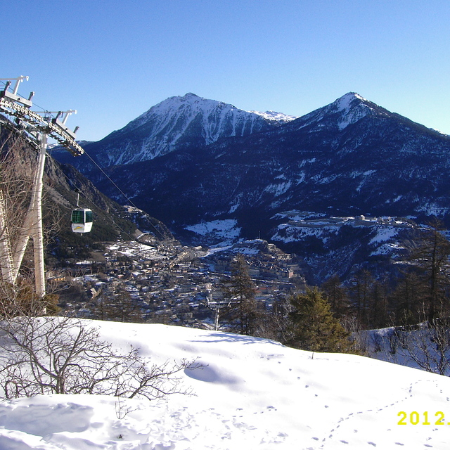
Briancon is also known as Serre Chevalier 1200. It is now fully part of the extensive SC system and linked in by a fast gondola to the Prorel mountain. The lift company has invested 50 million Euros into new lifts over the past few years so there are rarely any queues and plenty of new fast 6 person chair lifts. We have skied, as a family, at Serre Chevalier for the past 20 years but have also skied at most of the big resorts in France, Switzerland and Austria over the past 30 years. We return to SC every year as the locals are so helpful, the ski area is 250km of piste and well linked plus the resort is very family friendly. Because of the 4000m+ peaks surrounding SC low cloud can't get into the valley, so the local claim of 300 days of sunshine per year is valid. It is generally either snowing or blue skies. The snow record is better than anywhere else I know in the Alps and there is plenty of good skiing for beginners to advanced. Briancon is a decent size town so has 2 big supermarkets to help keep costs reasonable. The 'old town' is medieval and has UNESCO World Heritage status. Staying in Briancon is the best option but try and get close to the main access point at the Prorel Gondola (google 'Briancon apartments'). I'd suggest self catering as the local hotels are not great and quite expensive. There are also swimming pools and a 1st Division Ice Hockey team that is well worth watching (Les Diables Rouge). The Italian border is only 15 minutes drive away if you want a 'genuine' Italian meal. If you want more variety the lift pass allows 1 days skiing at several other local French & Italian resorts (La Grave, Les Deux Alpes, Montgenevre, Claviere, Sestriere, Puy St Vincent & Souze d'Oulx).
Mick from United Kingdom writes:
Briancon is also known as Serre Chevalier 1200. It is now fully part of the extensive SC system and linked in by a fast gondola to the Prorel mountain. The lift company has invested 50 million Euros into new lifts over the past few years so there are rarely any queues and plenty of new fast 6 person chair lifts. We have skied, as a family, at Serre Chevalier for the past 20 years but have also skied at most of the big resorts in France, Switzerland and Austria over the past 30 years. We return to SC every year as the locals are so helpful, the ski area is 250km of piste and well linked plus the resort is very family friendly. Because of the 4000m+ peaks surrounding SC low cloud can't get into the valley, so the local claim of 300 days of sunshine per year is valid. It is generally either snowing or blue skies. The snow record is better than anywhere else I know in the Alps and there is plenty of good skiing for beginners to advanced. Briancon is a decent size town so has 2 big supermarkets to help keep costs reasonable. The 'old town' is medieval and has UNESCO World Heritage status. Staying in Briancon is the best option but try and get close to the main access point at the Prorel Gondola (google 'Briancon apartments'). I'd suggest self catering as the local hotels are not great and quite expensive. There are also swimming pools and a 1st Division Ice Hockey team that is well worth watching (Les Diables Rouge). The Italian border is only 15 minutes drive away if you want a 'genuine' Italian meal. If you want more variety the lift pass allows 1 days skiing at several other local French & Italian resorts (La Grave, Les Deux Alpes, Montgenevre, Claviere, Sestriere, Puy St Vincent & Souze d'Oulx).


 Nearest