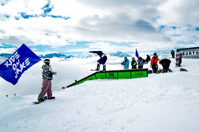
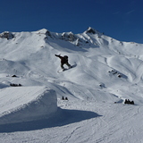
Avoriaz snow
Ski France

Avoriaz Snow Forecast

Weather Forecast for Avoriaz at 2254 m
Issued: 1 am  05 May 2025 (local time)

New snow in Avoriaz

6.0cm2.4in
Mon 5th (AM)
The snow forecast for Avoriaz is: A dusting of new snow. Freeze-thaw conditions (max 1°C on Tue morning, min -2°C on Mon night). Wind will be generally light.

Avoriaz Weather (Next 3 days): The snow forecast for Avoriaz is: A dusting of new snow. Freeze-thaw conditions (max 1°C on Tue morning, min -2°C on Mon night). Wind will be generally light.

Avoriaz Weather (Days 4-6): Moderate rain (total 16.0mm), heaviest on Sat night. Freeze-thaw conditions (max 4°C on Sat afternoon, min -1°C on Thu morning). Wind will be generally light.


Avoriaz Live Weather

ResortSnow DepthTemp. (°C)Wind (km/h)Weather
Top Lift: 0.0m
1
5
mod snow
Middle Lift: 
4
5
heavy rain
Bottom Lift: 0.0m
6
5
heavy rain
Powered by Snow-Forecast.comSnow-Forecast.com
6 Day Forecast
Issued: 1 am 05 May 2025 / Updates in ::
Change Forecast Height
Choose Forecast
Last 6 daysScroll left for last 6 daysNow
Monday
5
Tuesday
6
Wednesday
7
Thursday
8
Friday
9
Saturday
10
Sunday
11
AM
PM
night
AM
PM
night
AM
PM
night
AM
PM
night
AM
PM
night
AM
PM
night
AM
PM
night
light snow
light snow
light snow
cloud
light snow
cloud
light snow
light snow
light snow
light snow
light snow
snow showers
snow showers
snow showers
rain showers
part cloud
mod rain
mod rain
rain showers
thunderstorm
rain showers
light snow
light snow
light snow
cloudy
light snow
cloudy
light snow
light snow
light snow
light snow
light snow
snow shwrs
snow shwrs
snow shwrs
rain shwrs
some clouds
mod. rain
mod. rain
rain shwrs
risk thun- der
rain shwrs
 km/h
5
N
5
N
0
ESE
5
SE
5
NNW
0
S
0
NNW
5
NW
0
S
0
SSW
5
W
5
SW
0
E
0
NNW
5
S
0
WSW
5
WNW
5
S
0
WSW
5
WNW
5
SW
Snow map
 cm 
2.0
1.0
1.0
 mm 
1.0
1.0
6
8
1.0
5
2.0
max°C
0
0
-1
1
1
0
-1
-1
-1
-1
1
1
1
3
2
3
4
3
4
4
4
min°C
0
0
-2
-1
1
0
-1
-1
-1
-1
0
-1
0
2
1
2
4
2
3
4
2
chill°C 
-3
-2
-2
-1
1
0
-1
-1
-1
-1
0
-1
0
2
1
2
4
1
3
4
2
Humid% 
98
97
99
84
93
93
99
98
97
93
89
88
74
77
79
72
82
86
71
75
80
Freezing level (m
2200
2150
1900
2400
2400
2350
2150
2150
2100
2150
2350
2200
2450
2600
2550
2650
2800
2650
2750
2800
2700
topliftbotliftSea lvl1000m2000m3000m4000m5000m
00-2010-1-1-1-110132343443654565565686911711129121310
Sunrise
6:13
6:11
6:11
6:09
6:07
6:07
6:05
Sunset
8:45
8:46
8:47
8:49
8:50
8:52
8:52

Snow Radar

Submit a report Eyeball Reporter

Latest snow reports near Avoriaz:

  • 43 km away from Avoriaz

    2 hours ago
    weather station observation

    Light rain reported from Sion at 339 metres elevation only 2 kms NW of Veysonnaz-Printse but it is forecast cold enough for snow at higher elevations in the ski area from Veysonnaz-Printse

  • 43 km away from Avoriaz

    7 hours ago
    weather station observation

    Drizzle reported from Sion at 339 metres elevation only 2 kms NW of Veysonnaz-Printse but it is forecast cold enough for snow at higher elevations in the ski area from Veysonnaz-Printse

Avoriaz Snow Conditions

Top snow depth:0cm
Bottom snow depth:0cm
Fresh snowfall depth:
Last snowfall:23 Apr 2025
Snow AlertsCreate Alert
Other resorts in France are reporting: powder (0) / good piste (0)

Snow-Forecast Partner Offers

Snow History

Week 1 of May has on average:
0.1
Bluebird Powder days
Fresh snow, mostly sunny, light wind.
1.5
Powder days
Fresh snow, limited sun, any wind.
0.2
Bluebird days
Average snow, mostly sunny, light wind.

Avoriaz Resort Webcam

Live Snow webcam for Avoriaz
Most recent Avoriaz webcam image
Webcam courtesy of Avoriaz Tourist Office
  • 2pm yesterdayAvoriaz webcam at 2pm yesterday
  • 2 days agoAvoriaz webcam 1 days ago
  • 3 days agoAvoriaz webcam 2 days ago
  • 4 days agoAvoriaz webcam 3 days ago
  • 5 days agoAvoriaz webcam 4 days ago