

Global Weekly Snow Roundup #318
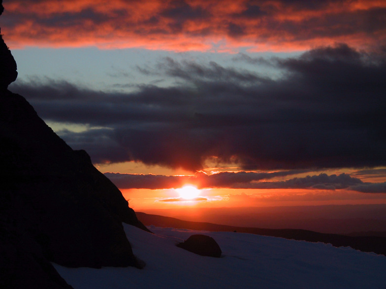
Weekly Snow News for the world, updated 11 June 2026: Australia's season begins, Val d’Isère reopens and major snowfall is forecast for the Andes.

Next 4 days weather summary:Light rain (total 2.0mm), mostly falling on Sun morning. Temperatures will be slightly above freezing (max 3°C on Fri night, min 1°C on Sun night). Winds increasing (light winds from the SSW on Fri night, fresh winds from the WNW by Sun night). | Days 5-7 weather summary:A dusting of new snow. Freeze-thaw conditions (max 1°C on Mon night, min -3°C on Tue afternoon). Winds decreasing (strong winds from the NW on Mon night, light winds from the WNW by Wed night). | |||||||||||||||
Saturday 13 | Sunday 14 | Monday 15 | Tuesday 16 | Wednesday 17 | ||||||||||||
night | AM | PM | night | AM | PM | night | AM | PM | night | AM | PM | night | AM | PM | night | |
clear | clear | some clouds | some clouds | light rain | cloudy | some clouds | some clouds | cloudy | snow shwrs | light snow | snow shwrs | clear | some clouds | cloudy | some clouds | |
km/h | ||||||||||||||||
Snow map | 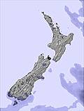 | 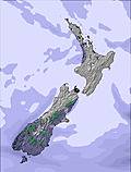 | 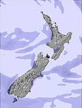 | 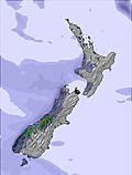 |  |  | ||||||||||
— | — | — | — | — | — | — | — | — | — | 2 | 1 | — | — | — | — | |
— | — | — | — | 2 | — | — | — | — | — | — | — | — | — | — | — | |
max °C | 3 | 3 | 2 | 3 | 3 | 3 | 3 | 2 | 2 | 1 | 0 | -2 | -1 | 0 | 1 | 1 |
min °C | 3 | 2 | 2 | 3 | 3 | 3 | 1 | 1 | 1 | 1 | -1 | -3 | -2 | 0 | 0 | 1 |
0 | -2 | -2 | -2 | -2 | -2 | -6 | -6 | -5 | -5 | -7 | -10 | -9 | -6 | -3 | -1 | |
64 | 55 | 89 | 86 | 85 | 83 | 82 | 87 | 83 | 72 | 98 | 81 | 69 | 60 | 57 | 46 | |
2550 | 2450 | 2350 | 2500 | 2800 | 2950 | 2850 | 2150 | 2350 | 2250 | 2000 | 1550 | 1450 | 1950 | 2150 | 2100 | |
— | 7:33 | — | — | 7:33 | — | — | 7:35 | — | — | 7:35 | — | — | 7:35 | — | — | |
— | — | 5:00 | — | — | 5:00 | — | — | 5:00 | — | — | 5:00 | — | — | 5:00 | — | |
Go pro and carve into:
Avalanche information: New Zealand Avalanche Advisory
Latest snow reports near Whakapapa:
| Top snow depth: | 0 cm |
|---|---|
| Bottom snow depth: | 0 cm |
| Fresh snowfall depth: | — |
| Last snowfall: | 6 Jun 2026 |
| Snow Alerts | Create Alert |
0.4 | Bluebird Powder days Fresh snow, mostly sunny, light wind. |
|---|---|
0.4 | Powder days Fresh snow, limited sun, any wind. |
0.5 | Bluebird days Average snow, mostly sunny, light wind. |
The above table gives the weather forecast for Whakapapa at the specific elevation of 1962 m. Our sophisticated weather models allow us to provide snow forecasts for the top, middle and bottom ski stations of Whakapapa. To access the weather forecasts for the other elevations, use the tab navigation above the table. For a wider view of the weather, check out the Weather Map of New Zealand.
Click here to read further information on freezing levels and how we forecast our temperatures.
Overall 3.3 Based on 52 votes and 59 reviews
I love this mountain and always will. I may have a different perspective to many because I always stay in one of the ski lodges on Whakapapa. Staying on the mountain is a beautiful experience. I took a party of 10 to stay at our lodge in August 2023 and we all had an amazing time, it was a great snow season. We tried the same again in August 2024 but the snow gods were not forthcoming. However, we improvised and did bush walks, hot pools and other activities to make up for the lack of snow and conditions. I have been coming here since I was a tiny tot in the late seventies so my views are the same, always a great experience at Whakapapa.
Geoff Powdrell from Australia writes:
I love this mountain and always will. I may have a different perspective to many because I always stay in one of the ski lodges on Whakapapa. Staying on the mountain is a beautiful experience. I took a party of 10 to stay at our lodge in August 2023 and we all had an amazing time, it was a great snow season. We tried the same again in August 2024 but the snow gods were not forthcoming. However, we improvised and did bush walks, hot pools and other activities to make up for the lack of snow and conditions. I have been coming here since I was a tiny tot in the late seventies so my views are the same, always a great experience at Whakapapa.


 Nearest