

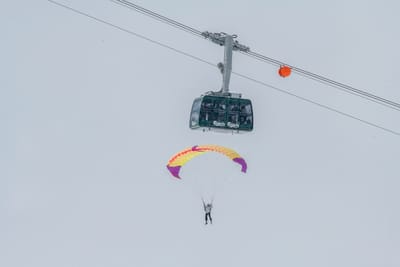
Verbier's Air Show This Weekend
Verbier's spectacular Air Show will returns to the famous Swiss resort this weekend with a three‑day programme combining aerial demonstrations and ground‑based entertainment across Verbier and Médran.

Next 4 days weather summary:A light covering of new snow, mostly falling on Mon afternoon. Temperatures will be well below freezing (max -6°C on Sun afternoon, min -14°C on Fri night). Wind will be generally light. | Days 5-7 weather summary:A dusting of new snow. Freeze-thaw conditions (max 1°C on Thu afternoon, min -7°C on Mon night). Wind will be generally light. | |||||||||||||||
Saturday 16 | Sunday 17 | Monday 18 | Tuesday 19 | Wednesday 20 | ||||||||||||
night | AM | PM | night | AM | PM | night | AM | PM | night | AM | PM | night | AM | PM | night | |
light snow | some clouds | light snow | snow shwrs | some clouds | light snow | light snow | light snow | light snow | light snow | light snow | light snow | light snow | cloudy | light snow | snow shwrs | |
km/h | ||||||||||||||||
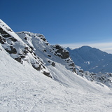
Snow map |  |  |  |  |  |  | ||||||||||
2 | — | 1 | — | — | — | — | — | 2 | 2 | — | — | 2 | — | — | — | |
— | — | — | — | — | — | — | — | — | — | — | — | — | — | — | — | |
max °C | -13 | -13 | -11 | -8 | -7 | -6 | -6 | -7 | -6 | -6 | -5 | -3 | -3 | -4 | -3 | -1 |
min °C | -14 | -14 | -12 | -10 | -7 | -7 | -7 | -7 | -6 | -7 | -5 | -4 | -5 | -5 | -4 | -3 |
-21 | -22 | -18 | -16 | -11 | -11 | -11 | -12 | -11 | -12 | -9 | -9 | -10 | -10 | -8 | -7 | |
95 | 93 | 83 | 64 | 49 | 87 | 92 | 91 | 92 | 96 | 97 | 86 | 91 | 82 | 96 | 40 | |
1200 | 1600 | 1900 | 1350 | 2300 | 2550 | 2200 | 2400 | 2450 | 2200 | 2450 | 2850 | 2650 | 2700 | 2850 | 3150 | |
— | 5:58 | — | — | 5:56 | — | — | 5:56 | — | — | 5:54 | — | — | 5:52 | — | — | |
— | — | — | 8:57 | — | — | 8:58 | — | — | 8:59 | — | — | 9:00 | — | — | 9:00 | |
Latest snow reports near Verbier:
| Top snow depth: | 0 cm |
|---|---|
| Bottom snow depth: | 0 cm |
| Fresh snowfall depth: | 16 cm |
| Last snowfall: | 14 May 2026 |
| Snow Alerts | Create Alert |
1.5 | Bluebird Powder days Fresh snow, mostly sunny, light wind. |
|---|---|
1.5 | Powder days Fresh snow, limited sun, any wind. |
1.6 | Bluebird days Average snow, mostly sunny, light wind. |
The above table gives the weather forecast for Verbier at the specific elevation of 3330 m. Our sophisticated weather models allow us to provide snow forecasts for the top, middle and bottom ski stations of Verbier. To access the weather forecasts for the other elevations, use the tab navigation above the table. For a wider view of the weather, check out the Weather Map of Switzerland.
Click here to read further information on freezing levels and how we forecast our temperatures.
Overall 4.1 Based on 103 votes and 97 reviews
Good off-piste opportunities in Verbier but... The 4 Vallees pass is overpriced for what it offers. The links between areas and lift infrastructure outside the Verbier area are poor with too many drag lifts and old, slow chairlifts with limited capacity. It suffers in comparison to other large linked ski areas such as Zermatt/Cervinia, 3 Vallees, Grand Massif etc. I get the feeling the area has been riding on the cachet of Verbier for too long and isn't really trying to be competitive.
Simon from United Kingdom writes:
Good off-piste opportunities in Verbier but...
The 4 Vallees pass is overpriced for what it offers. The links between areas and lift infrastructure outside the Verbier area are poor with too many drag lifts and old, slow chairlifts with limited capacity. It suffers in comparison to other large linked ski areas such as Zermatt/Cervinia, 3 Vallees, Grand Massif etc.
I get the feeling the area has been riding on the cachet of Verbier for too long and isn't really trying to be competitive.


 Nearest