

Global Weekly Snow Roundup #314
Weekly Global Snow News, updated 14 May 2026: Fresh snowfall in Argentina, Australia and Lesotho signals winter’s approach, while Japan maintains the world’s deepest snowpack.

Next 3 days weather summary:Light rain (total 8.0mm), mostly falling on Sun afternoon. Freeze-thaw conditions (max 6°C on Mon afternoon, min -3°C on Sat morning). Wind will be generally light. | Days 4-6 weather summary:Light rain (total 9.0mm), mostly falling on Tue afternoon. Very mild (max 14°C on Thu afternoon, min 5°C on Tue morning). Wind will be generally light. | |||||||||||||||||
Saturday 16 | Sunday 17 | Monday 18 | Tuesday 19 | Wednesday 20 | Thursday 21 | |||||||||||||
AM | PM | night | AM | PM | night | AM | PM | night | AM | PM | night | AM | PM | night | AM | PM | night | |
clear | some clouds | snow shwrs | some clouds | light rain | snow shwrs | light rain | light rain | rain shwrs | some clouds | light rain | rain shwrs | clear | rain shwrs | rain shwrs | clear | some clouds | rain shwrs | |
km/h | ||||||||||||||||||
Snow map |  |  |  |  |  |  | ||||||||||||
— | — | — | — | — | — | — | — | — | — | — | — | — | — | — | — | — | — | |
— | — | — | — | 2 | 1 | 1 | 2 | 2 | — | 3 | 3 | — | 1 | 1 | — | — | 1 | |
max °C | -1 | 2 | 1 | 2 | 3 | 3 | 4 | 6 | 6 | 6 | 7 | 6 | 9 | 11 | 10 | 13 | 14 | 13 |
min °C | -3 | 1 | 0 | 1 | 2 | 1 | 2 | 5 | 4 | 5 | 7 | 6 | 7 | 11 | 9 | 10 | 14 | 11 |
-8 | -1 | -2 | 1 | 2 | -2 | -1 | 2 | 3 | 3 | 7 | 5 | 4 | 11 | 8 | 10 | 14 | 11 | |
62 | 77 | 91 | 78 | 89 | 92 | 75 | 77 | 81 | 77 | 91 | 90 | 57 | 64 | 58 | 43 | 67 | 72 | |
2000 | 2400 | 2200 | 2350 | 2500 | 2400 | 2650 | 2800 | 2900 | 2950 | 3150 | 3100 | 3500 | 3550 | 3900 | 3950 | 3900 | 3950 | |
6:28 | — | — | 6:28 | — | — | 6:26 | — | — | 6:26 | — | — | 6:24 | — | — | 6:24 | — | — | |
— | — | 9:06 | — | — | 9:07 | — | — | 9:07 | — | — | 9:08 | — | — | 9:09 | — | — | 9:10 | |
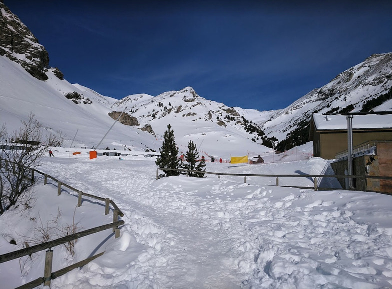
Latest snow reports near Vall de Núria:
| Top snow depth: | — |
|---|---|
| Bottom snow depth: | — |
| Fresh snowfall depth: | 10 cm |
| Last snowfall: | 15 May 2026 |
| Snow Alerts | Create Alert |
0.0 | Bluebird Powder days Fresh snow, mostly sunny, light wind. |
|---|---|
0.3 | Powder days Fresh snow, limited sun, any wind. |
0.1 | Bluebird days Average snow, mostly sunny, light wind. |
The above table gives the weather forecast for Vall de Núria at the specific elevation of 2115 m. Our sophisticated weather models allow us to provide snow forecasts for the top, middle and bottom ski stations of Vall de Núria. To access the weather forecasts for the other elevations, use the tab navigation above the table. For a wider view of the weather, check out the Weather Map of Spain.
Click here to read further information on freezing levels and how we forecast our temperatures.
Resort name is also written as Vall de Nuria.
Overall 3.7 Based on 2 votes and 3 reviews
After researching Nuria I came across the reviews here (and weirdly the exact same one on Tripadvisor and was almost put off enough to go to La Molina instead. Thank goodness I used my intuition and ignored the negative review. As a total novice visiting midweek I had an amazing day here and learnt to ski on a practically empty piste. I was accompanied by an experienced skier who enjoyed their experience too. This really is a great place, true it's compact and most suited to a day or two but it is so quiet and beautiful I cannot understand how anyone can dismiss it. It hadn't snowed for days when I visited but two of the three green slopes were excellent and the third was not bad if a little slushy. From what I am told the blue's were excellent. If you are looking for a quiet place to try out skiing while visiting BCN or Girona then give it a go. The negative review nearly put me off, don't let it put you off.
Jamie from United Kingdom writes:
After researching Nuria I came across the reviews here (and weirdly the exact same one on Tripadvisor and was almost put off enough to go to La Molina instead.
Thank goodness I used my intuition and ignored the negative review. As a total novice visiting midweek I had an amazing day here and learnt to ski on a practically empty piste. I was accompanied by an experienced skier who enjoyed their experience too. This really is a great place, true it's compact and most suited to a day or two but it is so quiet and beautiful I cannot understand how anyone can dismiss it.
It hadn't snowed for days when I visited but two of the three green slopes were excellent and the third was not bad if a little slushy. From what I am told the blue's were excellent.
If you are looking for a quiet place to try out skiing while visiting BCN or Girona then give it a go. The negative review nearly put me off, don't let it put you off.


 Nearest