

Australia's 2026 Season Starting With Fresh Snow
Mother Nature has delivered across the Australian Alps with near perfect timing for the start of the 2026 snow season tomorrow at most of the country's leading resorts, Saturday 6 June.

Next 3 days weather summary:Light rain (total 4.0mm), mostly falling on Mon afternoon. Very mild (max 19°C on Tue afternoon, min 13°C on Sun morning). Winds decreasing (strong winds from the NW on Sun morning, light winds from the SSW by Mon night). | Days 4-6 weather summary:Mostly dry. Warm (max 21°C on Wed afternoon, min 14°C on Wed morning). Winds decreasing (strong winds from the WNW on Wed night, calm by Thu night). | |||||||||||||||||
Sunday 7 | Monday 8 | Tuesday 9 | Wednesday 10 | Thursday 11 | Friday 12 | |||||||||||||
AM | PM | night | AM | PM | night | AM | PM | night | AM | PM | night | AM | PM | night | AM | PM | night | |
clear | cloudy | some clouds | clear | light rain | rain shwrs | some clouds | some clouds | some clouds | clear | clear | clear | some clouds | clear | some clouds | cloudy | some clouds | cloudy | |
km/h | ||||||||||||||||||
Snow map | 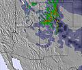 | 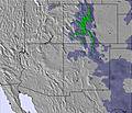 | 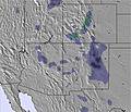 |  |  |  | ||||||||||||
— | — | — | — | — | — | — | — | — | — | — | — | — | — | — | — | — | — | |
— | — | — | — | 1 | 3 | — | — | — | — | — | — | — | — | — | — | — | — | |
max °C | 15 | 18 | 17 | 16 | 18 | 15 | 17 | 19 | 19 | 15 | 21 | 19 | 17 | 20 | 20 | 18 | 19 | 17 |
min °C | 13 | 18 | 14 | 15 | 14 | 14 | 15 | 19 | 14 | 14 | 19 | 15 | 15 | 19 | 16 | 16 | 19 | 15 |
10 | 17 | 13 | 14 | 12 | 12 | 14 | 18 | 12 | 12 | 18 | 13 | 13 | 19 | 15 | 16 | 19 | 14 | |
27 | 17 | 27 | 35 | 24 | 44 | 42 | 32 | 19 | 9 | 9 | 13 | 24 | 18 | 22 | 35 | 28 | 40 | |
4700 | 5050 | 4850 | 4800 | 5050 | 4900 | 4900 | 5300 | 5300 | 5050 | 5400 | 5350 | 5000 | 5250 | 5300 | 5150 | 5400 | 5350 | |
5:50 | — | — | 5:50 | — | — | 5:50 | — | — | 5:50 | — | — | 5:50 | — | — | 5:50 | — | — | |
— | 8:17 | — | — | 8:17 | — | — | 8:19 | — | — | 8:19 | — | — | 8:20 | — | — | 8:20 | — | |
Avalanche information: National Avalanche Center
Latest snow reports near Sandia Peak:
| Top snow depth: | — |
|---|---|
| Bottom snow depth: | — |
| Fresh snowfall depth: | — |
| Last snowfall: | 5 May 2026 |
| Snow Alerts | Create Alert |
0.0 | Bluebird Powder days Fresh snow, mostly sunny, light wind. |
|---|---|
0.0 | Powder days Fresh snow, limited sun, any wind. |
0.0 | Bluebird days Average snow, mostly sunny, light wind. |
The above table gives the weather forecast for Sandia Peak at the specific elevation of 2892 m. Our sophisticated weather models allow us to provide snow forecasts for the top, middle and bottom ski stations of Sandia Peak. To access the weather forecasts for the other elevations, use the tab navigation above the table. For a wider view of the weather, check out the Weather Map of United States.
Click here to read further information on freezing levels and how we forecast our temperatures.
Overall 2.1 Based on 2 votes and 2 reviews
Agradecería me envíen calendario del mes de diciembre para Sky en sandía peak,para saber que días esta abierta la montaña para planear las vacaciones ya que nuestros hijos lo que quieren es ir a skiar gracias x su atencion y esperando pronta respuesta quedo de ustedes. Claudia
Claudia from Mexico writes:
Agradecería me envíen calendario del mes de diciembre para Sky en sandía peak,para saber que días esta abierta la montaña para planear las vacaciones ya que nuestros hijos lo que quieren es ir a skiar gracias x su atencion y esperando pronta respuesta quedo de ustedes. Claudia


 Nearest