


Global Weekly Snow Roundup #314
Weekly Global Snow News, updated 14 May 2026: Fresh snowfall in Argentina, Australia and Lesotho signals winter’s approach, while Japan maintains the world’s deepest snowpack.

Next 3 days weather summary:Heavy rain (total 21.0mm), heaviest during Sat afternoon. Later becoming colder with a dusting of snow on Sat night. Mild temperatures (max 9°C on Mon afternoon, min 2°C on Sat night). Winds decreasing (fresh winds from the ESE on Sat afternoon, light winds from the S by Mon night). | Days 4-6 weather summary:Moderate rain (total 11.0mm), heaviest on Wed morning. Very mild (max 11°C on Wed afternoon, min 6°C on Wed night). Wind will be generally light. | ||||||||||||||||
Sat 16 | Sunday 17 | Monday 18 | Tuesday 19 | Wednesday 20 | Thursday 21 | ||||||||||||
PM | night | AM | PM | night | AM | PM | night | AM | PM | night | AM | PM | night | AM | PM | night | |
heavy rain | light snow | snow shwrs | rain shwrs | rain shwrs | some clouds | some clouds | cloudy | rain shwrs | cloudy | cloudy | light rain | light rain | light rain | light rain | light rain | rain shwrs | |
km/h | |||||||||||||||||
Snow map | 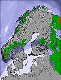 | 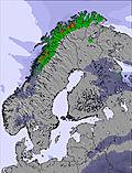 | 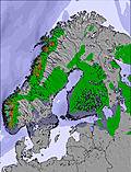 | 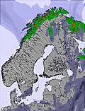 | 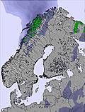 | 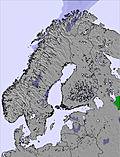 | |||||||||||
— | 2 | 2 | — | — | — | — | — | — | — | — | — | — | — | — | — | — | |
14 | 2 | 1 | 2 | 1 | — | — | — | 1 | — | — | 1 | 2 | 3 | 2 | 2 | 1 | |
max °C | 3 | 3 | 3 | 6 | 5 | 5 | 9 | 7 | 7 | 9 | 8 | 8 | 11 | 9 | 7 | 9 | 9 |
min °C | 3 | 2 | 2 | 4 | 2 | 3 | 7 | 5 | 7 | 8 | 7 | 8 | 10 | 6 | 6 | 8 | 6 |
-3 | -2 | -3 | 0 | -2 | 0 | 5 | 2 | 5 | 6 | 6 | 6 | 7 | 2 | 3 | 6 | 5 | |
97 | 98 | 89 | 76 | 80 | 75 | 50 | 74 | 74 | 72 | 76 | 71 | 63 | 91 | 85 | 81 | 88 | |
1400 | 1300 | 1250 | 1600 | 1500 | 1450 | 1900 | 1850 | 1800 | 2050 | 2050 | 2000 | 2200 | 2000 | 1950 | 2150 | 2250 | |
— | — | 4:16 | — | — | 4:13 | — | — | 4:11 | — | — | 4:09 | — | — | 4:07 | — | — | |
— | 9:47 | — | — | 9:51 | — | — | 9:52 | — | — | 9:55 | — | — | 9:58 | — | — | 10:00 | |
Latest snow reports near Sälen:
| Top snow depth: | — |
|---|---|
| Bottom snow depth: | — |
| Fresh snowfall depth: | — |
| Last snowfall: | 14 May 2026 |
| Snow Alerts | Create Alert |
0.0 | Bluebird Powder days Fresh snow, mostly sunny, light wind. |
|---|---|
0.3 | Powder days Fresh snow, limited sun, any wind. |
0.0 | Bluebird days Average snow, mostly sunny, light wind. |
The above table gives the weather forecast for Sälen at the specific elevation of 890 m. Our sophisticated weather models allow us to provide snow forecasts for the top, middle and bottom ski stations of Sälen. To access the weather forecasts for the other elevations, use the tab navigation above the table. For a wider view of the weather, check out the Weather Map of Sweden.
Click here to read further information on freezing levels and how we forecast our temperatures.
Resort name is also written as Salen.
Overall 4.5 Based on 1 vote and 3 reviews
I think Sälen and Sweden is great for skiing, especially if you have children. Lindvallen in particular is very family oriented and there are slopes for all abilities. I personally dislike resorts where there are nothing but steep slopes, so Sälen for me is perfect. There is something for everyone regardless of how experienced you are.
Maria Honeker from United Kingdom writes:
I think Sälen and Sweden is great for skiing, especially if you have children. Lindvallen in particular is very family oriented and there are slopes for all abilities. I personally dislike resorts where there are nothing but steep slopes, so Sälen for me is perfect. There is something for everyone regardless of how experienced you are.


 Nearest