


Global Weekly Snow Roundup #314
Weekly Global Snow News, updated 14 May 2026: Fresh snowfall in Argentina, Australia and Lesotho signals winter’s approach, while Japan maintains the world’s deepest snowpack.

Next 3 days weather summary:Light rain (total 2.0mm), mostly falling on Mon night. Very mild (max 18°C on Sat afternoon, min 6°C on Sun night). Winds increasing (calm on Sun morning, fresh winds from the WNW by Mon night). | Days 4-6 weather summary:Some drizzle, heaviest during Tue afternoon. Very mild (max 15°C on Thu morning, min 7°C on Wed night). Wind will be generally light. | ||||||||||||||||
Sat 16 | Sunday 17 | Monday 18 | Tuesday 19 | Wednesday 20 | Thursday 21 | ||||||||||||
PM | night | AM | PM | night | AM | PM | night | AM | PM | night | AM | PM | night | AM | PM | night | |
some clouds | some clouds | some clouds | cloudy | cloudy | cloudy | some clouds | rain shwrs | light rain | light rain | some clouds | some clouds | clear | clear | clear | some clouds | some clouds | |
km/h | |||||||||||||||||
Snow map | 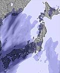 | 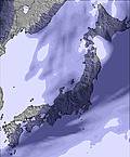 | 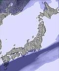 | 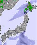 | 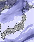 |  | |||||||||||
— | — | — | — | — | — | — | — | — | — | — | — | — | — | — | — | — | |
— | — | — | — | — | — | — | 1 | 1 | 1 | — | — | — | — | — | — | — | |
max °C | 18 | 12 | 9 | 9 | 9 | 14 | 14 | 11 | 12 | 11 | 9 | 13 | 13 | 10 | 15 | 14 | 9 |
min °C | 15 | 9 | 9 | 8 | 6 | 10 | 13 | 11 | 12 | 9 | 8 | 12 | 10 | 7 | 13 | 11 | 9 |
13 | 8 | 8 | 7 | 4 | 8 | 11 | 8 | 10 | 8 | 6 | 11 | 10 | 7 | 13 | 11 | 9 | |
59 | 90 | 89 | 89 | 95 | 83 | 67 | 83 | 84 | 79 | 67 | 51 | 48 | 72 | 38 | 56 | 78 | |
3500 | 3450 | 3800 | 3950 | 3500 | 3100 | 3550 | 3300 | 2750 | 2650 | 2650 | 2450 | 2400 | 2450 | 2650 | 2650 | 2700 | |
— | — | 4:03 | — | — | 4:01 | — | — | 4:01 | — | — | 4:00 | — | — | 4:00 | — | — | |
6:45 | — | — | 6:46 | — | — | 6:47 | — | — | 6:49 | — | — | 6:50 | — | — | 6:51 | — | |
Latest snow reports near Tokachi Sahoro Resort:
| Top snow depth: | 0 cm |
|---|---|
| Bottom snow depth: | 0 cm |
| Fresh snowfall depth: | — |
| Last snowfall: | 4 May 2026 |
| Snow Alerts | Create Alert |
0.0 | Bluebird Powder days Fresh snow, mostly sunny, light wind. |
|---|---|
0.0 | Powder days Fresh snow, limited sun, any wind. |
0.0 | Bluebird days Average snow, mostly sunny, light wind. |
The above table gives the weather forecast for Tokachi Sahoro Resort at the specific elevation of 820 m. Our sophisticated weather models allow us to provide snow forecasts for the top, middle and bottom ski stations of Tokachi Sahoro Resort. To access the weather forecasts for the other elevations, use the tab navigation above the table. For a wider view of the weather, check out the Weather Map of Japan.
Click here to read further information on freezing levels and how we forecast our temperatures.
Resort name is also written as Sahoro Resort.
Overall 3.5 Based on 14 votes and 6 reviews
Went to Club Med Sahoro in March 2013, for 1st ski trip, with 5 1/2 year old. Loved every second of it. Everything is easy; ski lessons, other kids to play with, easy food, ski in/out & build snowmen right outside door. Also have hot tub, indoor pool, toboggan etc. It is not the full European or USA experience but if you are looking for an easy skiing trip with young ones then this is the place to be. Last year I took my son by myself & it was easy. There were no queues, not even once and the slopes were nicely groomed with abundant snow. Heading there again in late Feb this year! Probably try somewhere different when he gets to 8 years old or so, but for now this is perfect.
Sam from Hong Kong writes:
Went to Club Med Sahoro in March 2013, for 1st ski trip, with 5 1/2 year old. Loved every second of it. Everything is easy; ski lessons, other kids to play with, easy food, ski in/out & build snowmen right outside door. Also have hot tub, indoor pool, toboggan etc.
It is not the full European or USA experience but if you are looking for an easy skiing trip with young ones then this is the place to be. Last year I took my son by myself & it was easy. There were no queues, not even once and the slopes were nicely groomed with abundant snow.
Heading there again in late Feb this year!
Probably try somewhere different when he gets to 8 years old or so, but for now this is perfect.
Read 5 more reviews of Tokachi Sahoro Resort or submit your own


 Nearest