Next snow in Remarkables: 0.9cm on Sun 14th (after 9 PM local time)
View forecast
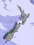
Remarkablesat 1990 m altitude
Issued by Snow-Forecast.com at:11 am (local time) / 12 Jun 2026
Last 6 daysScroll left for last 6 daysNow
Next 3 days weather summary:
Light rain (total 6.0mm) at first, then becoming colder with a dusting of snow on Sun night. Freeze-thaw conditions (max 3°C on Sun afternoon, min 0°C on Fri night). Winds increasing (light winds from the W on Fri morning, near gales from the NW by Sun afternoon).
Days 4-6 weather summary:
A light covering of new snow, mostly falling on Tue night. Freeze-thaw conditions (max 1°C on Wed night, min -5°C on Tue night). Winds increasing (calm on Mon morning, strong winds from the W by Tue afternoon).
Moderate to heavy rain showers reported from QueenstownAeroAws at 357 metres elevation 7 kms WNW of Remarkables but it is forecast cold enough for snow at higher elevations in the ski area from Remarkables
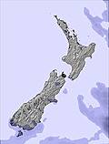
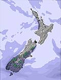
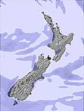
The above table gives the weather forecast for Remarkables at the specific elevation of 1990 m. Our sophisticated weather models allow us to provide snow forecasts for the top, middle and bottom ski stations of Remarkables. To access the weather forecasts for the other elevations, use the tab navigation above the table. For a wider view of the weather, check out the Weather Map of New Zealand.
Click here to read further information on freezing levels and how we forecast our temperatures.
Wow, just reading through some of these reviews and they seem very harsh. We have been here the past 3 years from Melbourne and the staff and runs are awesome by comparison to our 'most of the time' conditions in Victoria. Yes, it takes a bit of time to organise gear on the 1st day but, seriously, you only have to do it once and not lug it to your accommodation (which is what you do in Vic); imagine lugging you gear and getting your kids to do the same across country to the chalet!! Love the runs, love the people working up there on Cardrona and Remarks... always found the instructors to be awesome and I guess the restaurant staff muck around but, yep... its a drudge having done it myself. Some can keep up the attitude, some can't. First world problem. Just enjoy and get out there!
Wow, just reading through some of these reviews and they seem very harsh. We have been here the past 3 years from Melbourne and the staff and runs are awesome by comparison to our 'most of the time' conditions in Victoria. Yes, it takes a bit of time to organise gear on the 1st day but, seriously, you only have to do it once and not lug it to your accommodation (which is what you do in Vic); imagine lugging you gear and getting your kids to do the same across country to the chalet!! Love the runs, love the people working up there on Cardrona and Remarks... always found the instructors to be awesome and I guess the restaurant staff muck around but, yep... its a drudge having done it myself. Some can keep up the attitude, some can't. First world problem. Just enjoy and get out there!
Free Snow-Forecast.com weather widget for your website
Embed the Remarkables weather widget on your site for free. It provides a weekly snapshot of snow and rain conditions across all elevations. Follow the two quick steps to grab your custom code and paste it into your site. Choose between metric or imperial units. Click here to get the code.


 Nearest