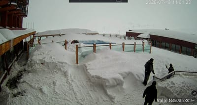
Red Mountain Resort snow
Ski Canada - BC

Red Mountain Resort Snow Forecast

Weather Forecast for Red Mountain Resort at 2073 m
Issued: 3 am  06 Nov 2025 (local time)

Popular Red Mountain Resort Pages

New snow in Red Mountain Resort

2.8cm1.1in
Thu 6th (AM)
The snow forecast for Red Mountain Resort is: A moderate fall of snow, heaviest on Thu night. Freeze-thaw conditions (max 2°C on Sat night, min -5°C on Thu night). Winds decreasing (fresh winds from the SSW on Thu night, calm by Fri night).

Red Mountain Resort Weather (Next 3 days): The snow forecast for Red Mountain Resort is: A moderate fall of snow, heaviest on Thu night. Freeze-thaw conditions (max 2°C on Sat night, min -5°C on Thu night). Winds decreasing (fresh winds from the SSW on Thu night, calm by Fri night).

Red Mountain Resort Weather (Days 4-6): Mostly dry. Freeze-thaw conditions (max 4°C on Sun afternoon, min -3°C on Mon night). Winds decreasing (fresh winds from the SW on Sun night, light winds from the SW by Tue night).


Red Mountain Resort Live Weather

ResortSnow DepthTemp. (°C)Wind (km/h)Weather
Top Lift: 0.0m
-2
20
light snow
Middle Lift: 
1
15
light snow
Bottom Lift: 0.0m
3
15
light rain
Powered by Snow-Forecast.comSnow-Forecast.com
6 Day Forecast
Issued: 3 am 06 Nov 2025 / Updates in ::
Change Forecast Height
Choose Forecast
Last 6 daysScroll left for last 6 daysNow
Thursday
6
Friday
7
Saturday
8
Sunday
9
Monday
10
Tuesday
11
Wednesday
12
AM
PM
night
AM
PM
night
AM
PM
night
AM
PM
night
AM
PM
night
AM
PM
night
AM
PM
night
snow showers
light snow
heavy snow
part cloud
clear
part cloud
part cloud
clear
part cloud
part cloud
part cloud
cloud
part cloud
part cloud
part cloud
part cloud
cloud
cloud
part cloud
part cloud
cloud
snow shwrs
light snow
heavy snow
some clouds
clear
some clouds
some clouds
clear
some clouds
some clouds
some clouds
cloudy
some clouds
some clouds
some clouds
some clouds
cloudy
cloudy
some clouds
some clouds
cloudy
 km/h
15
SW
20
SSW
25
SSW
30
WNW
30
NW
10
NW
5
WSW
5
SW
5
WSW
5
SW
10
SW
25
SW
30
WSW
15
WSW
20
WNW
15
WNW
10
WSW
5
SW
15
SW
10
SW
20
SW
Snow map
 cm 
14
 mm 
max°C
-1
-1
-2
-3
-3
-3
-3
-1
2
3
4
4
1
-1
-1
-2
-1
-1
0
1
1
min°C
-2
-1
-5
-5
-3
-4
-4
-2
0
2
4
2
-1
-1
-3
-3
-1
-2
-1
0
1
chill°C 
-7
-6
-13
-13
-10
-8
-4
-2
-2
0
1
-4
-6
-6
-9
-8
-5
-6
-5
-4
-4
Humid% 
90
83
98
81
68
63
62
59
65
50
43
44
75
73
84
78
67
64
83
75
78
Freezing level (m
1750
1900
1450
1400
1700
1300
1250
1500
1500
3700
3900
3800
2450
1900
1650
1400
1600
1600
1600
2200
2400
topliftbotliftSea lvl1000m2000m3000m4000m5000m
-2-1-4-4-3-4-4-213430-1-2-3-1-2-11154131-220-132132-1321322
Sunrise
6:46
6:48
6:48
6:50
6:52
6:54
6:56
Sunset
4:22
4:21
4:19
4:17
4:15
4:15
4:14
Popular Red Mountain Resort Pages

Snow Radar

Latest snow reports near Red Mountain Resort:

No recent snow reports

No recent snow reports

Red Mountain Resort Snow Conditions

Top snow depth:0cm
Bottom snow depth:0cm
Fresh snowfall depth:9cm
Last snowfall: 5 Nov 2025
Snow AlertsCreate Alert
Other resorts in Canada - BC are reporting: powder (0) / good piste (0)


Snow History

Week 1 of November has on average:
0.7
Bluebird Powder days
Fresh snow, mostly sunny, light wind.
1.0
Powder days
Fresh snow, limited sun, any wind.
1.1
Bluebird days
Average snow, mostly sunny, light wind.


Snow-Forecast Partner Offers

Red Mountain Resort Resort Webcam

Live Snow webcam for Red Mountain Resort
Most recent Red Mountain Resort webcam image
Webcam courtesy of Red Mountain Resort website
  • 2pm yesterdayRed Mountain Resort webcam at 2pm yesterday
  • 2 days agoRed Mountain Resort webcam 1 days ago
  • 3 days agoRed Mountain Resort webcam 2 days ago
  • 4 days agoRed Mountain Resort webcam 3 days ago
  • 5 days agoRed Mountain Resort webcam 4 days ago