

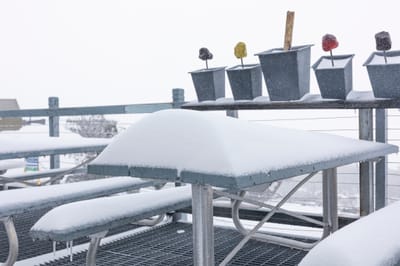
Australia's 2026 Season Starting With Fresh Snow
Mother Nature has delivered across the Australian Alps with near perfect timing for the start of the 2026 snow season tomorrow at most of the country's leading resorts, Saturday 6 June.

Next 4 days weather summary:Mostly dry. Warm (max 21°C on Tue afternoon, min 12°C on Sat night). Mainly fresh winds. | Days 5-7 weather summary:Light rain (total 3.0mm), mostly falling on Thu morning. Warm (max 21°C on Wed afternoon, min 13°C on Tue night). Wind will be generally light. | |||||||||||||||
Sunday 7 | Monday 8 | Tuesday 9 | Wednesday 10 | Thursday 11 | ||||||||||||
night | AM | PM | night | AM | PM | night | AM | PM | night | AM | PM | night | AM | PM | night | |
some clouds | cloudy | some clouds | clear | clear | clear | some clouds | clear | clear | clear | clear | clear | clear | light rain | cloudy | cloudy | |
km/h | ||||||||||||||||
Snow map | 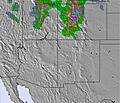 | 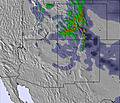 | 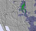 | 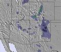 | 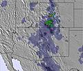 | 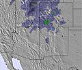 | ||||||||||
— | — | — | — | — | — | — | — | — | — | — | — | — | — | — | — | |
— | — | — | — | — | — | — | — | — | — | — | — | — | 2 | — | — | |
max °C | 16 | 17 | 19 | 15 | 18 | 19 | 16 | 19 | 21 | 17 | 19 | 21 | 17 | 18 | 19 | 18 |
min °C | 12 | 15 | 19 | 12 | 16 | 19 | 14 | 17 | 21 | 13 | 18 | 21 | 13 | 17 | 19 | 16 |
10 | 14 | 18 | 9 | 14 | 18 | 12 | 16 | 21 | 11 | 18 | 21 | 12 | 17 | 19 | 16 | |
40 | 35 | 29 | 29 | 32 | 29 | 35 | 37 | 21 | 24 | 19 | 19 | 27 | 45 | 46 | 37 | |
4700 | 4600 | 4850 | 4750 | 4700 | 4900 | 5000 | 5100 | 5250 | 5150 | 5150 | 5300 | 5200 | 5100 | 5150 | 5250 | |
— | 5:15 | — | — | 5:15 | — | — | 5:15 | — | — | 5:15 | — | — | 5:15 | — | — | |
— | — | 7:28 | — | — | 7:29 | — | — | 7:29 | — | — | 7:29 | — | — | 7:30 | — | |
Avalanche information: National Avalanche Center
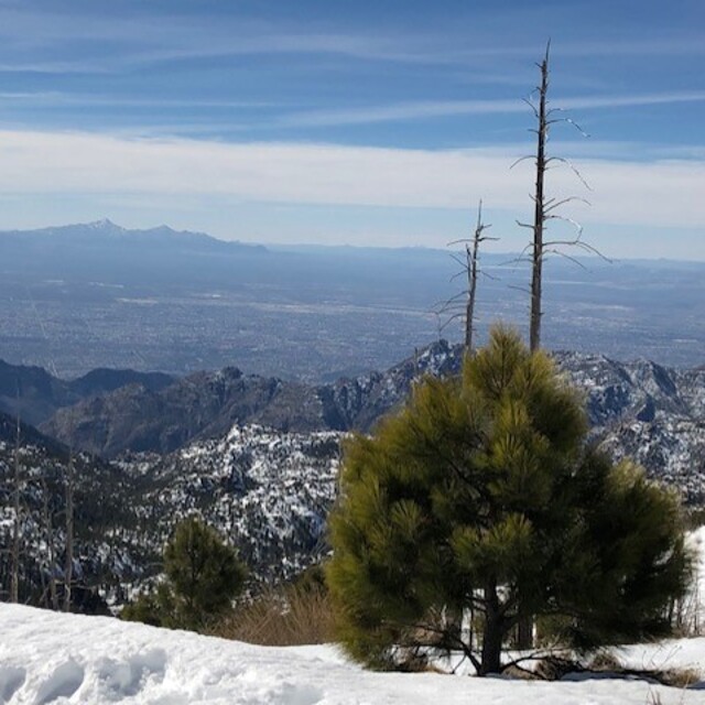
Latest snow reports near Mount Lemmon Ski Valley:
| Top snow depth: | — |
|---|---|
| Bottom snow depth: | — |
| Fresh snowfall depth: | — |
| Last snowfall: | 9 Mar 2026 |
| Snow Alerts | Create Alert |
0.0 | Bluebird Powder days Fresh snow, mostly sunny, light wind. |
|---|---|
0.0 | Powder days Fresh snow, limited sun, any wind. |
0.0 | Bluebird days Average snow, mostly sunny, light wind. |
The above table gives the weather forecast for Mount Lemmon Ski Valley at the specific elevation of 2514 m. Our sophisticated weather models allow us to provide snow forecasts for the top, middle and bottom ski stations of Mount Lemmon Ski Valley. To access the weather forecasts for the other elevations, use the tab navigation above the table. For a wider view of the weather, check out the Weather Map of United States.
Click here to read further information on freezing levels and how we forecast our temperatures.
Overall 2.9 Based on 7 votes and 2 reviews
Tried to go up the Catalina Hwy to ski Mt. Lemmon, but the line of cars waiting to go up was huge and would have taken all day. The ski area should have a shuttle for those wanting to ski. It was obvious that a lot of the cars had skiers/snowboarders waiting to go up. Lots of lost business. I turned around and went home.
K from United States writes:
Tried to go up the Catalina Hwy to ski Mt. Lemmon, but the line of cars waiting to go up was huge and would have taken all day. The ski area should have a shuttle for those wanting to ski. It was obvious that a lot of the cars had skiers/snowboarders waiting to go up. Lots of lost business. I turned around and went home.
Read 1 more reviews of Mount Lemmon Ski Valley or submit your own


 Nearest