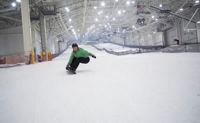
Logo
Snowfall warning for North Island New Zealand Issued 24 July at 10am local time. A deepening sub-tropical depression will quickly cross North Island on Saturday accompanied by a short period of gales and heavy rain. Expect easterly blizzard conditions to develop on Ruapehu as well as the ranges from the Tararuas to the Kawekas and perhaps even further north. A Cool SE flow with further bands of snow for mountains elsewhere. Many resorts have seen more than 20cm snow over the past 24hrs.

Mount Elbrus, Russia

Resort Info Webcams Snow Report Historical Snow Current Weather Resort Reviews
6 Day Forecast
(free)
top: 5642m
mid: 4422m
bot: 3203m
2 Day Detail
(subscribers)
top: 5642m
mid: 4422m
bot: 3203m
9 Day Forecast
(subscribers)
top: 5642m
mid: 4422m
bot: 3203m
Piste Map Weather Maps Snowfinder
Printable Forecast
6 Day Weather Forecast for 3203 m altitude, issued (local time): 02 am 24 Jul 2008
  Days 0-3 Mount Elbrus Weather Summary: Mostly dry. Very mild (max 13°C on Fri morning, min 5°C on Fri night). Wind will be generally light. Days 4-6 Mount Elbrus Weather Summary: Light rain (total 3.0mm), mostly falling on Sun afternoon . Very mild (max 11°C on Sun morning, min 2°C on Mon night). Wind will be generally light.
Thu
24
morn-
ing
Thu
24
after-
noon
Thu
24
night
Fri
25
morn-
ing
Fri
25
after-
noon
Fri
25
night
Sat
26
morn-
ing
Sat
26
after-
noon
Sat
26
night
Sun
27
morn-
ing
Sun
27
after-
noon
Sun
27
night
Mon
28
morn-
ing
Mon
28
after-
noon
Mon
28
night
Tue
29
morn-
ing
Tue
29
after-
noon
Tue
29
night
 
Wind (km/h)
Summary clear clear clear clear some clouds clear some clouds some clouds clear clear rain shwrs clear clear rain shwrs clear clear some clouds some clouds
Snow cm - - - - - - - - - - - - - - - - - -
Rain mm - - - - - - - - - - 2 - - 1 - - - -
Max °C 10 11 8 13 13 6 13 13 7 11 10 5 10 9 4 8 8 5
Min °C 9 10 6 11 11 5 12 11 5 10 9 4 9 8 2 7 5 4
WChill °C 7 9 5 10 10 5 11 10 3 9 8 1 7 5 -3 4 3 2
Freezing level (m) 4600 4700 4800 4900 5000 4900 4900 4950 4900 4600 4650 4650 4450 4550 4350 4250 4350 4200
Sunrise 4:52 - - 4:52 - - 4:54 - - 4:54 - - 4:56 - - 4:56 - -
Sunset - 19:40 - - 19:39 - - 19:38 - - 19:37 - - 19:37 - - 19:36 -

The above table gives the weather forecast for Mount Elbrus at the specific elevation of 3203 m. Our sophisticated weather models allow us to provide snow forecasts for the top, middle and bottom stations of Mount Elbrus. To access the weather forecasts for the other elevations, use the tab navigation above the table. For a wider view of the weather, check out the Weather Map" of Russia (Russian Federation).

NOTE ABOUT FREEZING LEVELS AND TEMPERATURES
The freezing level that we forecast Mount Elbrus is the  free air freezing level. (More specifically, it is the uppermost free air freezing level). This means that all of the air above this elevation is below freezing however it does not necessarily imply that all of the air below it is above freezing.  We provide this because it best describes the level where falling snow first starts to turn to rain. On average, snowflakes only stay frozen for about 100 metres (300 feet) below the free air freezing level. That's because air temperatures usually increase steadily as you descend - but not always.  For example, a temperature inversion describes a pool of cold air near the ground with a layer of warmer air above it. This is a common occurrence in winter when the wind is light. Such pools of dense cold air can vary from a few metres to several kilometres deep and can persist from hours to several weeks. In an inversion, it can be simultaneously below freezing in a mountain valley, and also at a nearby summit, yet above freezing at some elevation in between. Most visitors to the Alps are very familiar with this. Such conditions can allow snow to fall much more than the usual 100 metres below the top freezing level, even reaching the valley, just as long as snow did not pass through enough warm air to melt. Otherwise, freezing rain or re-frozen soft hail (there is even a German word for it - graupel) reaches the valley instead. Our forecasts allow for these possibilities which is why you may see forecasts of snowfall and frost at elevations far below the free-air freezing level, or valley temperatures that are lower than summit temperatures. You may even see forecasts of rain to fall even though it is just below freezing at the surface - that happens if our model predicts that there is a deep warm layer just above. None of these are as contradictory as they may seem at first.

All of our temperature forecasts for Mount Elbrus are for the ground, not the air. These can be very different to free-air temperatures, especially at night. This can lead to what looks like a contradiction. Because the ground is such a good radiator of heat (especially on clear nights when there is a snow cover and the wind is light) surface temperatures often fall more than far below the free air temperatures - sometimes by more than 10 degrees. On such occasions, the snowpack freezes at elevations that are far below the free air freezing level. For example, in the European Alps, snow tends to freeze in valleys on still clear and still nights  even if the free air freezing level is above 3000m simply because snow is so efficient radiating its heat away. In reality there are two freezing levels; one just above the snow surface and another at 3000m with a layer of warmer temperatures in between where the snow may not freeze at all. In summary, the reason we provide surface temperatures is because these determine the condition of the snowpack.


FREE Mount Elbrus Weather Feed for your site:


Simply copy and paste the code below into your pages!