

Portillo Storm Snowfall Total Passes 5m / 17 Feet
A snow storm that has now continued for nine days has taken Chilean ski resort Portillo to a snowfall total of 5.2 metres (17 feet) so far, with more snow forecast.

Next 3 days weather summary:Mostly dry. Very mild (max 15°C on Fri afternoon, min 7°C on Wed morning). Wind will be generally light. | Days 4-6 weather summary:Light rain (total 6.0mm), mostly falling on Sat night. Freeze-thaw conditions (max 15°C on Sat afternoon, min -1°C on Sun night). Winds decreasing (strong winds from the SSW on Sat afternoon, calm by Mon night). | |||||||||||||||||
Wednesday 29 | Thursday 30 | Friday 31 | Saturday 1 | Sunday 2 | Monday 3 | |||||||||||||
AM | PM | night | AM | PM | night | AM | PM | night | AM | PM | night | AM | PM | night | AM | PM | night | |
clear | clear | clear | cloudy | clear | clear | clear | clear | clear | clear | some clouds | rain shwrs | clear | cloudy | light snow | light snow | light rain | light rain | |
km/h | ||||||||||||||||||
Snow map | 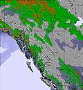 | 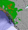 | 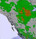 | 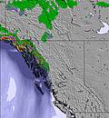 | 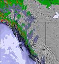 | 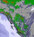 | ||||||||||||
— | — | — | — | — | — | — | — | — | — | — | — | — | — | — | — | — | — | |
mm | — | — | — | — | — | — | — | — | — | — | — | 3 | — | — | — | — | 2 | 1 |
max °C | 8 | 12 | 11 | 11 | 14 | 13 | 13 | 15 | 15 | 14 | 15 | 10 | 3 | 6 | 5 | 2 | 4 | 4 |
min °C | 7 | 10 | 8 | 9 | 13 | 10 | 11 | 14 | 12 | 13 | 15 | 1 | 1 | 5 | -1 | 0 | 3 | 2 |
chill °C | 4 | 8 | 7 | 8 | 12 | 9 | 9 | 13 | 11 | 11 | 13 | -4 | -4 | 2 | -4 | -2 | 0 | 2 |
Humid % | 64 | 42 | 35 | 47 | 31 | 39 | 39 | 33 | 39 | 37 | 30 | 61 | 76 | 55 | 84 | 82 | 68 | 84 |
Freeze m | 3650 | 3950 | 4100 | 4050 | 4350 | 4400 | 4350 | 4550 | 4650 | 4600 | 4600 | 3450 | 2800 | 3300 | 2950 | 2600 | 3050 | 2950 |
6:03 | — | — | 6:03 | — | — | 6:05 | — | — | 6:07 | — | — | 6:09 | — | — | 6:09 | — | — | |
— | — | 9:37 | — | — | 9:35 | — | — | 9:34 | — | — | 9:31 | — | — | 9:30 | — | — | 9:29 | |
Go pro and carve into:
Avalanche information: Avalanche Canada
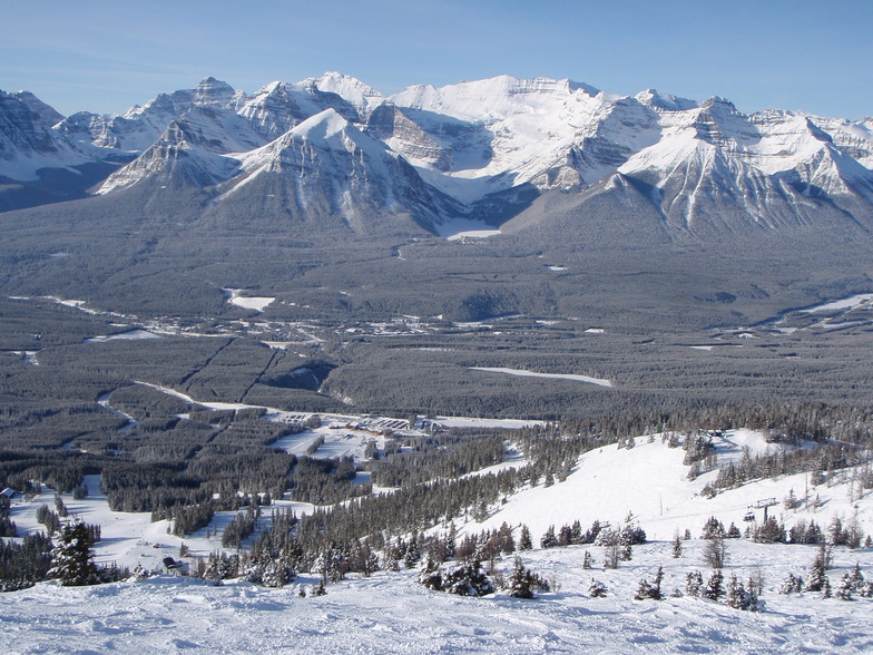
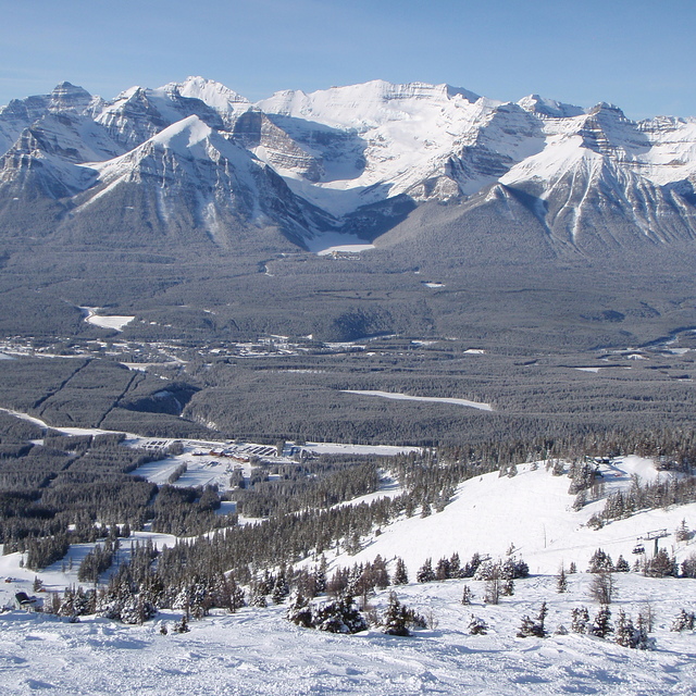
Latest snow reports near Lake Louise:
| Top snow depth: | 0 cm |
|---|---|
| Bottom snow depth: | 0 cm |
| Fresh snowfall depth: | — |
| Last snowfall: | 17 Jun 2026 |
| Snow Alerts | Create Alert |
0.0 | Bluebird Powder days Fresh snow, mostly sunny, light wind. |
|---|---|
0.1 | Powder days Fresh snow, limited sun, any wind. |
0.0 | Bluebird days Average snow, mostly sunny, light wind. |
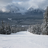
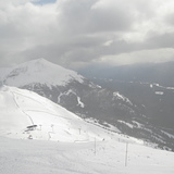
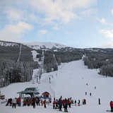
The above table gives the weather forecast for Lake Louise at the specific elevation of 2636 m. Our sophisticated weather models allow us to provide snow forecasts for the top, middle and bottom ski stations of Lake Louise. To access the weather forecasts for the other elevations, use the tab navigation above the table. For a wider view of the weather, check out the Weather Map of Canada.
Click here to read further information on freezing levels and how we forecast our temperatures.
Overall 3.8 Based on 46 votes and 40 reviews
Much overrated hill. Too much grooming. Most of the runs are groomed which make skiing very boring. The front side is only for beginners. Snow report is misleading at best. Don't waste your time on this hill. For my money Norquay has much better skiing, especially the runs serviced by the North America chair.
mike delorme from Canada writes:
Much overrated hill. Too much grooming. Most of the runs are groomed which make skiing very boring. The front side is only for beginners. Snow report is misleading at best. Don't waste your time on this hill. For my money Norquay has much better skiing, especially the runs serviced by the North America chair.


 Nearest