

Portillo Storm Snowfall Total Passes 5m / 17 Feet
A snow storm that has now continued for nine days has taken Chilean ski resort Portillo to a snowfall total of 5.2 metres (17 feet) so far, with more snow forecast.

Next 3 days weather summary:Mostly dry. Warm (max 20°C on Fri afternoon, min 10°C on Wed morning). Wind will be generally light. | Days 4-6 weather summary:Moderate rain (total 10.0mm), heaviest on Sat night. Very mild (max 19°C on Sat afternoon, min 2°C on Sun night). Winds decreasing (fresh winds from the SW on Sat afternoon, calm by Mon night). | |||||||||||||||||
Wednesday 29 | Thursday 30 | Friday 31 | Saturday 1 | Sunday 2 | Monday 3 | |||||||||||||
AM | PM | night | AM | PM | night | AM | PM | night | AM | PM | night | AM | PM | night | AM | PM | night | |
clear | clear | clear | cloudy | clear | clear | clear | clear | clear | clear | some clouds | rain shwrs | clear | cloudy | light rain | light rain | light rain | light rain | |
km/h | ||||||||||||||||||
Snow map |  |  |  | 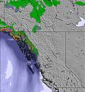 | 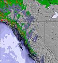 | 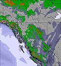 | ||||||||||||
— | — | — | — | — | — | — | — | — | — | — | — | — | — | — | — | — | — | |
mm | — | — | — | — | — | — | — | — | — | — | — | 3 | — | — | 3 | 1 | 2 | 1 |
max °C | 12 | 16 | 15 | 15 | 18 | 17 | 17 | 20 | 19 | 18 | 19 | 14 | 7 | 10 | 9 | 6 | 8 | 8 |
min °C | 10 | 14 | 10 | 12 | 17 | 12 | 14 | 19 | 14 | 16 | 19 | 4 | 5 | 10 | 2 | 4 | 8 | 5 |
chill °C | 8 | 13 | 10 | 12 | 17 | 12 | 13 | 19 | 14 | 15 | 18 | 0 | 2 | 8 | 0 | 3 | 7 | 5 |
Humid % | 63 | 37 | 34 | 51 | 27 | 41 | 40 | 29 | 38 | 38 | 26 | 70 | 70 | 48 | 83 | 77 | 59 | 78 |
Freeze m | 3650 | 3950 | 4100 | 4050 | 4350 | 4400 | 4350 | 4550 | 4650 | 4600 | 4600 | 3450 | 2800 | 3300 | 2950 | 2600 | 3050 | 2950 |
6:03 | — | — | 6:03 | — | — | 6:05 | — | — | 6:07 | — | — | 6:09 | — | — | 6:09 | — | — | |
— | — | 9:37 | — | — | 9:35 | — | — | 9:34 | — | — | 9:31 | — | — | 9:30 | — | — | 9:29 | |
Go pro and carve into:
Avalanche information: Avalanche Canada
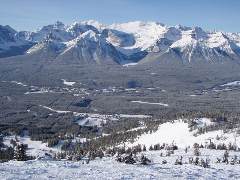
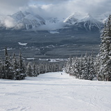
Latest snow reports near Lake Louise:
| Top snow depth: | 0 cm |
|---|---|
| Bottom snow depth: | 0 cm |
| Fresh snowfall depth: | — |
| Last snowfall: | 17 Jun 2026 |
| Snow Alerts | Create Alert |
0.0 | Bluebird Powder days Fresh snow, mostly sunny, light wind. |
|---|---|
0.0 | Powder days Fresh snow, limited sun, any wind. |
0.0 | Bluebird days Average snow, mostly sunny, light wind. |
The above table gives the weather forecast for Lake Louise at the specific elevation of 2141 m. Our sophisticated weather models allow us to provide snow forecasts for the top, middle and bottom ski stations of Lake Louise. To access the weather forecasts for the other elevations, use the tab navigation above the table. For a wider view of the weather, check out the Weather Map of Canada.
Click here to read further information on freezing levels and how we forecast our temperatures.
Overall 3.8 Based on 46 votes and 40 reviews
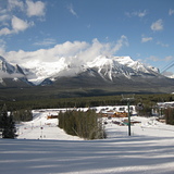
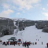
Amazing ski hill! Lots of amazing runs for every level of expertise. Also, the view from the top of the new Summit chair is a must see. Staff are very friendly. Just an approximate 5 min drive from Fairmont Chateau Lake Louise. An absolute must experience.
Esmonde Holowaty from Canada writes:
Amazing ski hill! Lots of amazing runs for every level of expertise. Also, the view from the top of the new Summit chair is a must see. Staff are very friendly. Just an approximate 5 min drive from Fairmont Chateau Lake Louise. An absolute must experience.


 Nearest