

Global Weekly Snow Roundup #314
Weekly Global Snow News, updated 14 May 2026: Fresh snowfall in Argentina, Australia and Lesotho signals winter’s approach, while Japan maintains the world’s deepest snowpack.

Next 3 days weather summary:A light covering of new snow, mostly falling on Mon afternoon. Temperatures will be below freezing (max -2°C on Sun afternoon, min -10°C on Sat morning). Wind will be generally light. | Days 4-6 weather summary:Mostly dry. Freeze-thaw conditions (max 7°C on Thu morning, min -1°C on Tue morning). Wind will be generally light. | |||||||||||||||||
Saturday 16 | Sunday 17 | Monday 18 | Tuesday 19 | Wednesday 20 | Thursday 21 | |||||||||||||
AM | PM | night | AM | PM | night | AM | PM | night | AM | PM | night | AM | PM | night | AM | PM | night | |
some clouds | light snow | snow shwrs | cloudy | snow shwrs | light snow | light snow | light snow | light snow | cloudy | light snow | snow shwrs | clear | some clouds | some clouds | clear | clear | clear | |
km/h | ||||||||||||||||||
Snow map |  |  |  |  |  |  | ||||||||||||
— | 1 | — | — | — | — | 1 | 3 | 3 | — | — | — | — | — | — | — | — | — | |
— | — | — | — | — | — | — | — | — | — | — | — | — | — | — | — | — | — | |
max °C | -9 | -7 | -4 | -3 | -2 | -2 | -3 | -2 | -2 | -1 | 0 | 1 | 2 | 4 | 5 | 7 | 7 | 7 |
min °C | -10 | -8 | -7 | -3 | -2 | -4 | -4 | -3 | -3 | -1 | -1 | 0 | 1 | 3 | 4 | 5 | 7 | 7 |
-16 | -12 | -11 | -5 | -4 | -7 | -7 | -7 | -5 | -3 | -4 | -4 | -2 | 1 | 2 | 3 | 6 | 6 | |
86 | 88 | 46 | 43 | 90 | 92 | 88 | 89 | 98 | 84 | 96 | 68 | 58 | 75 | 40 | 20 | 36 | 23 | |
1600 | 1900 | 1450 | 2350 | 2550 | 2250 | 2350 | 2400 | 2200 | 2550 | 2700 | 2850 | 3050 | 3200 | 3650 | 3750 | 3800 | 4100 | |
6:01 | — | — | 6:01 | — | — | 6:00 | — | — | 5:58 | — | — | 5:58 | — | — | 5:56 | — | — | |
— | — | 8:57 | — | — | 8:58 | — | — | 9:00 | — | — | 9:00 | — | — | 9:01 | — | — | 9:02 | |
Latest snow reports near La Tania:
| Top snow depth: | — |
|---|---|
| Bottom snow depth: | — |
| Fresh snowfall depth: | 13 cm |
| Last snowfall: | 15 May 2026 |
| Snow Alerts | Create Alert |
0.4 | Bluebird Powder days Fresh snow, mostly sunny, light wind. |
|---|---|
0.8 | Powder days Fresh snow, limited sun, any wind. |
0.7 | Bluebird days Average snow, mostly sunny, light wind. |


The above table gives the weather forecast for La Tania at the specific elevation of 2738 m. Our sophisticated weather models allow us to provide snow forecasts for the top, middle and bottom ski stations of La Tania. To access the weather forecasts for the other elevations, use the tab navigation above the table. For a wider view of the weather, check out the Weather Map of France.
Click here to read further information on freezing levels and how we forecast our temperatures.
Overall 3.9 Based on 24 votes and 24 reviews
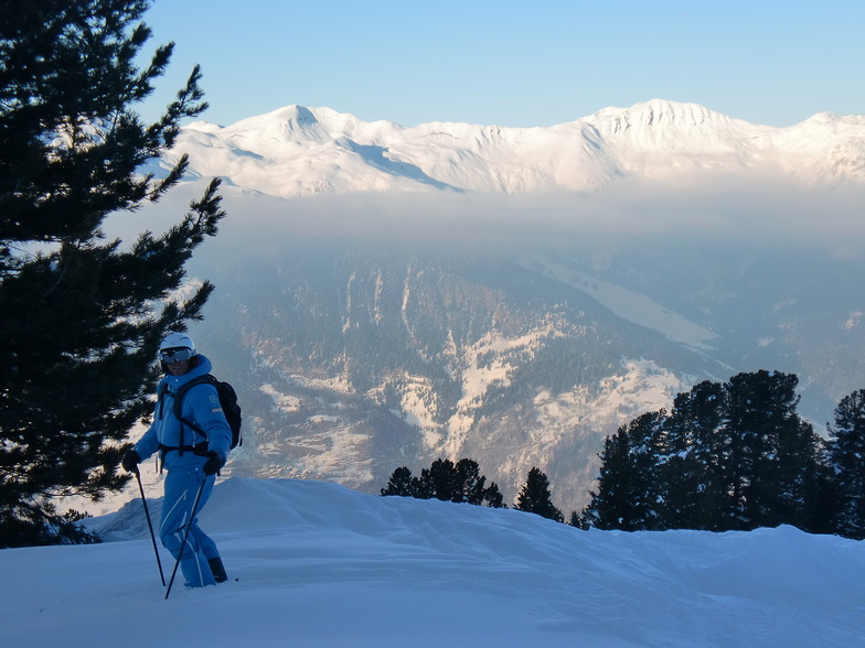
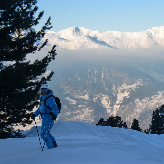
The conditions in La Tania and Courchevel have been incredible this weekend (January 31st), with a huge amount of fresh snow last week. With the continuous snowfall forecast the next week, it's looking like, despite the slow start, this will be an epic winter.
Mrs C. Smith from United Kingdom writes:
The conditions in La Tania and Courchevel have been incredible this weekend (January 31st), with a huge amount of fresh snow last week. With the continuous snowfall forecast the next week, it's looking like, despite the slow start, this will be an epic winter.


 Nearest