

Global Weekly Snow Roundup #314
Weekly Global Snow News, updated 14 May 2026: Fresh snowfall in Argentina, Australia and Lesotho signals winter’s approach, while Japan maintains the world’s deepest snowpack.

Next 3 days weather summary:Mostly dry. Freeze-thaw conditions (max 4°C on Sun afternoon, min 0°C on Sat night). Wind will be generally light. | Days 4-6 weather summary:Mostly dry. Freeze-thaw conditions (max 7°C on Thu afternoon, min 0°C on Tue night). Wind will be generally light. | |||||||||||||||||
Saturday 16 | Sunday 17 | Monday 18 | Tuesday 19 | Wednesday 20 | Thursday 21 | |||||||||||||
AM | PM | night | AM | PM | night | AM | PM | night | AM | PM | night | AM | PM | night | AM | PM | night | |
cloudy | cloudy | some clouds | clear | clear | clear | clear | clear | some clouds | cloudy | light snow | snow shwrs | some clouds | cloudy | some clouds | clear | clear | some clouds | |
km/h | ||||||||||||||||||
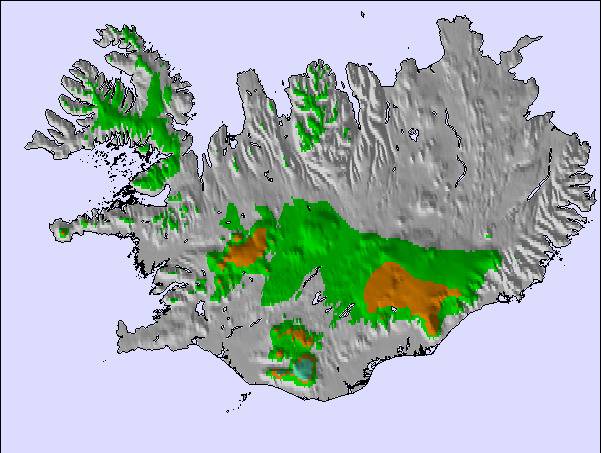
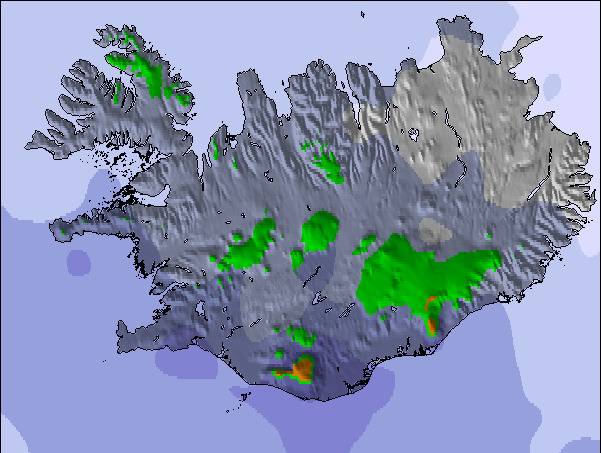
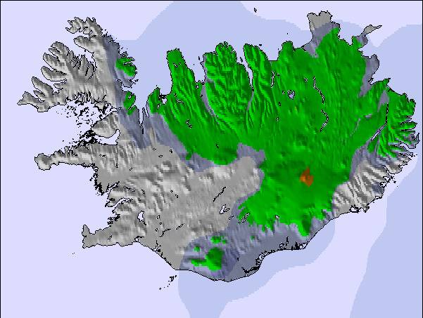
Snow map |  |  |  |  |  |  | ||||||||||||
— | — | — | — | — | — | — | — | — | — | — | 1 | — | — | — | — | — | — | |
— | — | — | — | — | — | — | — | — | — | — | — | — | — | — | — | — | — | |
max °C | 1 | 2 | 2 | 1 | 4 | 3 | 2 | 3 | 2 | 1 | 2 | 0 | 0 | 0 | 1 | 5 | 7 | 7 |
min °C | 1 | 2 | 0 | 0 | 3 | 2 | 2 | 3 | 0 | 1 | 1 | 0 | 0 | 0 | 0 | 3 | 7 | 5 |
-1 | 0 | 0 | -2 | 3 | 2 | 0 | 1 | 0 | 1 | -1 | -2 | 0 | -2 | 0 | 1 | 6 | 4 | |
80 | 77 | 78 | 72 | 46 | 49 | 60 | 63 | 81 | 82 | 82 | 97 | 80 | 84 | 76 | 44 | 39 | 54 | |
1150 | 1200 | 1150 | 1000 | 1300 | 1350 | 1200 | 1300 | 1150 | 1100 | 1200 | 950 | 950 | 1000 | 950 | 1450 | 1950 | 2100 | |
3:35 | — | — | 3:32 | — | — | 3:29 | — | — | 3:25 | — | — | 3:20 | — | — | 3:16 | — | — | |
— | — | 10:44 | — | — | 10:47 | — | — | 10:52 | — | — | 10:55 | — | — | 11:00 | — | — | 11:04 | |
Latest snow reports near Hlíðarfjall Akureyri:
| Top snow depth: | — |
|---|---|
| Bottom snow depth: | — |
| Fresh snowfall depth: | — |
| Last snowfall: | 12 May 2026 |
| Snow Alerts | Create Alert |
0.2 | Bluebird Powder days Fresh snow, mostly sunny, light wind. |
|---|---|
1.3 | Powder days Fresh snow, limited sun, any wind. |
0.9 | Bluebird days Average snow, mostly sunny, light wind. |
The above table gives the weather forecast for Hlíðarfjall Akureyri at the specific elevation of 980 m. Our sophisticated weather models allow us to provide snow forecasts for the top, middle and bottom ski stations of Hlíðarfjall Akureyri. To access the weather forecasts for the other elevations, use the tab navigation above the table. For a wider view of the weather, check out the Weather Map of Iceland.
Click here to read further information on freezing levels and how we forecast our temperatures.
Resort name is also written as Hlidarfjall Akureyri.
Overall 3.7 Based on 2 votes and 2 reviews
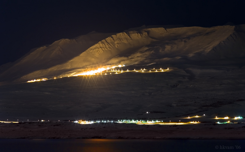
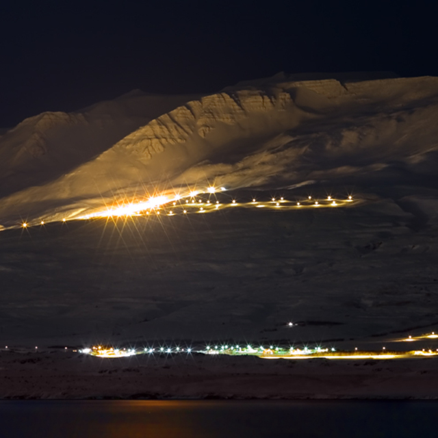
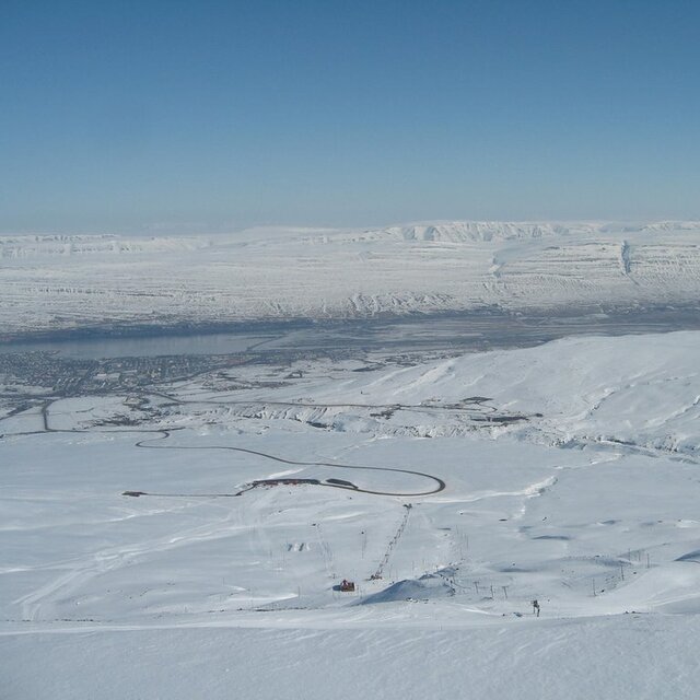
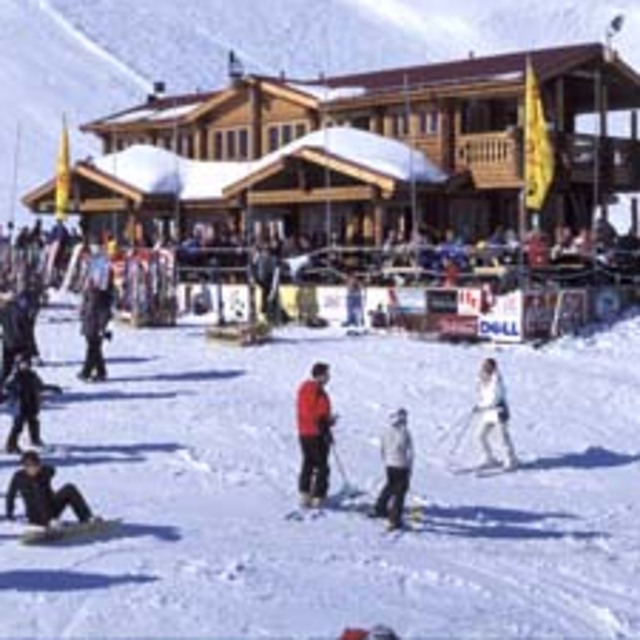
Situated between 500 and 1,000m above sea level, seven kilometres from the Icelandic city of Akureyri, Hlidarfjall is one of the country’s top ski resorts, boasting excellent pistes for beginner to upper intermediate level skiers, cross-country trails and off-piste skiing. Night-time skiing on illuminated pistes is also on offer. The resort base, located at 500m, has only the most necessary facilities of a single ski lodge (the Stryta lodge), toilets, shops and a cafeteria. However, the city of Akureyri offers a multitude of visitor services, shops, accommodation options and recreational opportunities. Hlidarfjall is a small, personal resort, with only 12kms of groomed pistes, the longest being 2.5kms. The resort caters mainly for lower level skiers, with only green and blue pistes on offer. There are four ski lifts in Hlidarfjall, able to transport 2,000 skiers per hour. Additionally, the resort encompasses five kilometres of illuminated cross-country tracks, and snowboarders have access to a terrain park with jumps, slides and tables. Between Hlidarfjall and Akureyri, there are a multitude of alternative winter activities on offer. Visitors have access to a superb ice-skating rink and swimming pools heated by geothermal activity. Sports and leisure activities are also available, including a number of fitness centres. Hlidarfjall’s ski season runs from mid-December to the end of April, with optimal snow from February to March, and cheaper rates offered at the beginning of the season, in selected weeks in January, and towards the season’s close. The easiest way of accessing the resort is to take a flight to Reykjavik, Iceland’s capital, then a domestic flight to Akureyri, and the Skibus to Hlidarfjall.
Yar Dmitriev from United States writes:
Situated between 500 and 1,000m above sea level, seven kilometres from the Icelandic city of Akureyri, Hlidarfjall is one of the country’s top ski resorts, boasting excellent pistes for beginner to upper intermediate level skiers, cross-country trails and off-piste skiing. Night-time skiing on illuminated pistes is also on offer.
The resort base, located at 500m, has only the most necessary facilities of a single ski lodge (the Stryta lodge), toilets, shops and a cafeteria. However, the city of Akureyri offers a multitude of visitor services, shops, accommodation options and recreational opportunities.
Hlidarfjall is a small, personal resort, with only 12kms of groomed pistes, the longest being 2.5kms. The resort caters mainly for lower level skiers, with only green and blue pistes on offer. There are four ski lifts in Hlidarfjall, able to transport 2,000 skiers per hour. Additionally, the resort encompasses five kilometres of illuminated cross-country tracks, and snowboarders have access to a terrain park with jumps, slides and tables.
Between Hlidarfjall and Akureyri, there are a multitude of alternative winter activities on offer. Visitors have access to a superb ice-skating rink and swimming pools heated by geothermal activity. Sports and leisure activities are also available, including a number of fitness centres.
Hlidarfjall’s ski season runs from mid-December to the end of April, with optimal snow from February to March, and cheaper rates offered at the beginning of the season, in selected weeks in January, and towards the season’s close. The easiest way of accessing the resort is to take a flight to Reykjavik, Iceland’s capital, then a domestic flight to Akureyri, and the Skibus to Hlidarfjall.
Read 1 more reviews of Hlíðarfjall Akureyri or submit your own

 Nearest