


Global Weekly Snow Roundup #314
Weekly Global Snow News, updated 14 May 2026: Fresh snowfall in Argentina, Australia and Lesotho signals winter’s approach, while Japan maintains the world’s deepest snowpack.

Next 3 days weather summary:A dusting of snow turning to light rain (total 5.0mm) on Sun afternoon. Freeze-thaw conditions (max 4°C on Sun afternoon, min 0°C on Sat morning). Wind will be generally light. | Days 4-6 weather summary:Heavy rain (total 26.0mm), heaviest during Wed night. Mild temperatures (max 6°C on Wed afternoon, min 2°C on Thu morning). Winds decreasing (fresh winds from the SSE on Wed night, calm by Thu afternoon). | |||||||||||||||||
Saturday 16 | Sunday 17 | Monday 18 | Tuesday 19 | Wednesday 20 | Thursday 21 | |||||||||||||
AM | PM | night | AM | PM | night | AM | PM | night | AM | PM | night | AM | PM | night | AM | PM | night | |
light snow | light snow | light snow | light snow | rain shwrs | rain shwrs | some clouds | light rain | light rain | light rain | light rain | light rain | light rain | cloudy | mod. rain | light rain | light rain | rain shwrs | |
km/h | ||||||||||||||||||
Snow map | 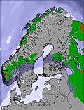 | 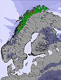 | 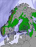 | 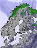 | 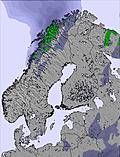 | 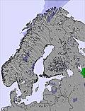 | ||||||||||||
1 | 1 | — | — | — | — | — | — | — | — | — | — | — | — | — | — | — | — | |
— | — | — | — | 2 | 1 | — | 1 | 1 | 2 | 2 | 3 | 2 | — | 8 | 2 | 3 | 4 | |
max °C | 0 | 0 | 0 | 1 | 4 | 4 | 2 | 4 | 4 | 5 | 5 | 5 | 3 | 6 | 5 | 3 | 4 | 4 |
min °C | 0 | 0 | 0 | 0 | 3 | 1 | 2 | 3 | 3 | 3 | 5 | 3 | 3 | 5 | 5 | 2 | 4 | 4 |
-4 | -3 | -3 | -4 | 0 | -2 | -2 | -2 | -2 | -2 | 1 | -1 | -1 | 1 | 0 | -3 | 1 | 2 | |
99 | 99 | 94 | 96 | 83 | 87 | 98 | 91 | 94 | 85 | 88 | 97 | 90 | 80 | 99 | 97 | 96 | 93 | |
1200 | 1150 | 1100 | 1250 | 1600 | 1600 | 1450 | 1700 | 1650 | 1800 | 1800 | 1700 | 1550 | 2050 | 2050 | 1450 | 1650 | 1750 | |
4:31 | — | — | 4:28 | — | — | 4:26 | — | — | 4:24 | — | — | 4:20 | — | — | 4:18 | — | — | |
— | — | 10:00 | — | — | 10:04 | — | — | 10:06 | — | — | 10:08 | — | — | 10:10 | — | — | 10:14 | |
Latest snow reports near Gausdal:
| Top snow depth: | — |
|---|---|
| Bottom snow depth: | — |
| Fresh snowfall depth: | 12 cm |
| Last snowfall: | 15 May 2026 |
| Snow Alerts | Create Alert |
0.0 | Bluebird Powder days Fresh snow, mostly sunny, light wind. |
|---|---|
0.1 | Powder days Fresh snow, limited sun, any wind. |
0.1 | Bluebird days Average snow, mostly sunny, light wind. |
The above table gives the weather forecast for Gausdal at the specific elevation of 1123 m. Our sophisticated weather models allow us to provide snow forecasts for the top, middle and bottom ski stations of Gausdal. To access the weather forecasts for the other elevations, use the tab navigation above the table. For a wider view of the weather, check out the Weather Map of Norway.
Click here to read further information on freezing levels and how we forecast our temperatures.
Overall 3.6 Based on 10 votes and 1 review
We skiied Gausdal along with Hafjell and Kvitfjell as part of a long weekend in Lillihammer at the end of March, in Norway, when the Alps were turning to slush. Gausdal is higher than the other two and above the tree line and consequently has better late season snow. The conditions were great when we were there. Front side of the mountain is served by an 8 man high speed weather proofed chair serving a number of really nice blue, red and black (but really dark red) runs that you can do a lot of fast skiing on; the back side is all T-bar lifts and is slightly hard work. But the compensation is the view across to Oppland and the completely empty country in between and the empty pistes. If you have a car and have a few days in the area it's worth a visit.
keith panter from United Kingdom writes:
We skiied Gausdal along with Hafjell and Kvitfjell as part of a long weekend in Lillihammer at the end of March, in Norway, when the Alps were turning to slush.
Gausdal is higher than the other two and above the tree line and consequently has better late season snow. The conditions were great when we were there.
Front side of the mountain is served by an 8 man high speed weather proofed chair serving a number of really nice blue, red and black (but really dark red) runs that you can do a lot of fast skiing on; the back side is all T-bar lifts and is slightly hard work. But the compensation is the view across to Oppland and the completely empty country in between and the empty pistes. If you have a car and have a few days in the area it's worth a visit.


 Nearest