


Global Weekly Snow Roundup #314
Weekly Global Snow News, updated 14 May 2026: Fresh snowfall in Argentina, Australia and Lesotho signals winter’s approach, while Japan maintains the world’s deepest snowpack.

Next 3 days weather summary:A dusting of snow giving way to moderate rain (total 13.0mm) heaviest on Sat afternoon. Freeze-thaw conditions (max 7°C on Sat afternoon, min 0°C on Sat night). Winds decreasing (strong winds from the ESE on Sat night, light winds from the WSW by Sun night). | Days 4-6 weather summary:Light rain (total 4.0mm), mostly falling on Tue morning. Very mild (max 10°C on Wed afternoon, min 4°C on Mon night). Mainly fresh winds. | ||||||||||||||||
Fri 15 | Saturday 16 | Sunday 17 | Monday 18 | Tuesday 19 | Wednesday 20 | ||||||||||||
PM | night | AM | PM | night | AM | PM | night | AM | PM | night | AM | PM | night | AM | PM | night | |
light rain | rain shwrs | light snow | light rain | light snow | light snow | light rain | cloudy | some clouds | cloudy | some clouds | light rain | light rain | light rain | some clouds | some clouds | some clouds | |
km/h | |||||||||||||||||
Snow map | 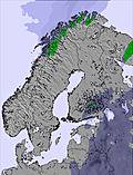 | 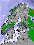 | 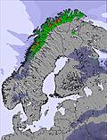 | 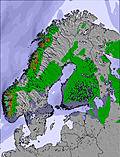 | 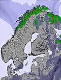 | 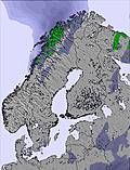 | |||||||||||
— | — | 3 | — | — | — | — | — | — | — | — | — | — | — | — | — | — | |
2 | 1 | 1 | 4 | 3 | — | 2 | — | — | — | — | 1 | 2 | 1 | — | — | — | |
max °C | 3 | 4 | 3 | 7 | 4 | 2 | 4 | 4 | 5 | 6 | 6 | 7 | 9 | 6 | 7 | 10 | 9 |
min °C | 2 | 3 | 1 | 4 | 0 | 1 | 2 | 3 | 3 | 6 | 4 | 6 | 7 | 4 | 5 | 9 | 6 |
-3 | -2 | -5 | -2 | -5 | -4 | -3 | 0 | -2 | 2 | -1 | 2 | 2 | 0 | 1 | 6 | 2 | |
88 | 83 | 99 | 81 | 97 | 98 | 89 | 89 | 87 | 86 | 90 | 86 | 84 | 94 | 63 | 52 | 81 | |
1200 | 1500 | 1100 | 1800 | 950 | 1150 | 1350 | 1550 | 1500 | 1750 | 1850 | 1850 | 1900 | 1850 | 1900 | 2200 | 2200 | |
— | — | 4:09 | — | — | 4:07 | — | — | 4:03 | — | — | 4:01 | — | — | 3:59 | — | — | |
— | 10:00 | — | — | 10:02 | — | — | 10:06 | — | — | 10:08 | — | — | 10:12 | — | — | 10:15 | |
Latest snow reports near Funäsdalen:
| Top snow depth: | — |
|---|---|
| Bottom snow depth: | — |
| Fresh snowfall depth: | 10 cm |
| Last snowfall: | 14 May 2026 |
| Snow Alerts | Create Alert |
0.1 | Bluebird Powder days Fresh snow, mostly sunny, light wind. |
|---|---|
0.2 | Powder days Fresh snow, limited sun, any wind. |
0.3 | Bluebird days Average snow, mostly sunny, light wind. |
The above table gives the weather forecast for Funäsdalen at the specific elevation of 899 m. Our sophisticated weather models allow us to provide snow forecasts for the top, middle and bottom ski stations of Funäsdalen. To access the weather forecasts for the other elevations, use the tab navigation above the table. For a wider view of the weather, check out the Weather Map of Sweden.
Click here to read further information on freezing levels and how we forecast our temperatures.
Resort name is also written as Funasdalen.
Overall 3.6 Based on 2 votes and 1 review
Great atmosphere, great snow. The only bad thing is that the slopes are a bit short. Try the cross country-skiing. Funasdalen has 300km of x-country trail, that's the largest system in the world! Best time to go there is in April, when the days are longer and the temperatures are a bit warmer.
Hans from Sweden writes:
Great atmosphere, great snow. The only bad thing is that the slopes are a bit short.
Try the cross country-skiing. Funasdalen has 300km of x-country trail, that's the largest system in the world!
Best time to go there is in April, when the days are longer and the temperatures are a bit warmer.


 Nearest