

Global Weekly Snow Roundup #314
Weekly Global Snow News, updated 14 May 2026: Fresh snowfall in Argentina, Australia and Lesotho signals winter’s approach, while Japan maintains the world’s deepest snowpack.

Next 3 days weather summary:Light rain (total 5.0mm), mostly falling on Mon night. Freeze-thaw conditions (max 12°C on Mon afternoon, min -1°C on Sat morning). Wind will be generally light. | Days 4-6 weather summary:Light rain (total 3.0mm), mostly falling on Tue afternoon. Warm (max 20°C on Thu afternoon, min 7°C on Tue night). Wind will be generally light. | |||||||||||||||||
Saturday 16 | Sunday 17 | Monday 18 | Tuesday 19 | Wednesday 20 | Thursday 21 | |||||||||||||
AM | PM | night | AM | PM | night | AM | PM | night | AM | PM | night | AM | PM | night | AM | PM | night | |
clear | cloudy | cloudy | cloudy | rain shwrs | light rain | some clouds | some clouds | rain shwrs | cloudy | rain shwrs | rain shwrs | clear | clear | clear | clear | some clouds | some clouds | |
km/h | ||||||||||||||||||
Snow map |  |  |  |  |  |  | ||||||||||||
— | — | — | — | — | — | — | — | — | — | — | — | — | — | — | — | — | — | |
— | — | — | — | 2 | 1 | — | — | 2 | — | 2 | 1 | — | — | — | — | — | — | |
max °C | 3 | 6 | 4 | 6 | 7 | 5 | 8 | 12 | 9 | 10 | 12 | 10 | 12 | 16 | 15 | 17 | 20 | 15 |
min °C | -1 | 6 | 3 | 3 | 7 | 3 | 4 | 11 | 7 | 8 | 12 | 7 | 8 | 15 | 12 | 12 | 19 | 14 |
-4 | 4 | 1 | 3 | 6 | 0 | 2 | 9 | 6 | 7 | 12 | 6 | 7 | 15 | 11 | 10 | 19 | 14 | |
87 | 83 | 97 | 81 | 79 | 92 | 67 | 55 | 75 | 78 | 79 | 81 | 72 | 54 | 44 | 53 | 42 | 47 | |
2150 | 2400 | 2150 | 2250 | 2500 | 2350 | 2850 | 2850 | 3000 | 2900 | 3100 | 3600 | 3900 | 3900 | 4050 | 3750 | 3750 | 3800 | |
6:56 | — | — | 6:56 | — | — | 6:54 | — | — | 6:54 | — | — | 6:52 | — | — | 6:52 | — | — | |
— | — | 9:37 | — | — | 9:38 | — | — | 9:39 | — | — | 9:40 | — | — | 9:42 | — | — | 9:43 | |
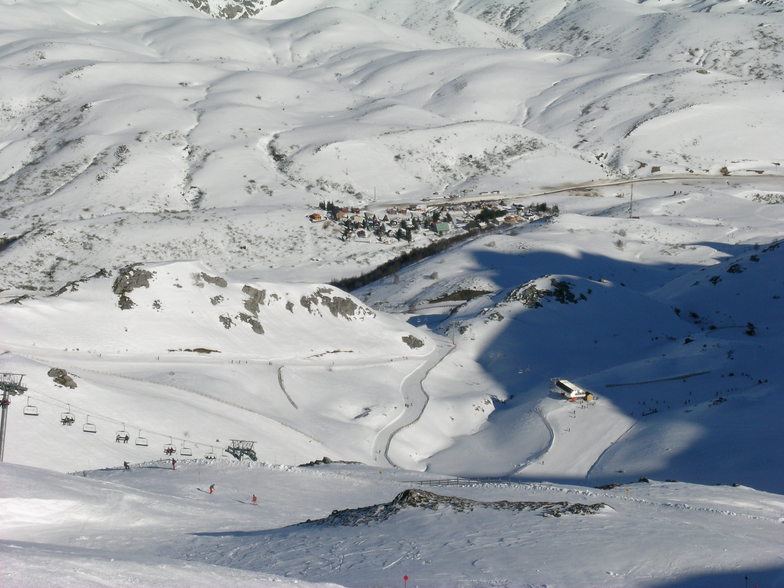
Latest snow reports near Fuentes de Invierno:
| Top snow depth: | — |
|---|---|
| Bottom snow depth: | — |
| Fresh snowfall depth: | 17 cm |
| Last snowfall: | 15 May 2026 |
| Snow Alerts | Create Alert |
0.0 | Bluebird Powder days Fresh snow, mostly sunny, light wind. |
|---|---|
0.0 | Powder days Fresh snow, limited sun, any wind. |
0.0 | Bluebird days Average snow, mostly sunny, light wind. |


The above table gives the weather forecast for Fuentes de Invierno at the specific elevation of 1501 m. Our sophisticated weather models allow us to provide snow forecasts for the top, middle and bottom ski stations of Fuentes de Invierno. To access the weather forecasts for the other elevations, use the tab navigation above the table. For a wider view of the weather, check out the Weather Map of Spain.
Click here to read further information on freezing levels and how we forecast our temperatures.
Overall 3.2 Based on 33 votes and 3 reviews
Es una magnífica estación. De dimensiones reducidas, sorprende por la belleza de algunas de sus pistas y por la longitud de la pista de debutantes que llega hasta la parte más baja de la estación. Respetuosa con el medio ambiente (la anchura de sus pistas no es la ideal por esa razón), ofrece un paisaje espléndido a la vista y unos fuera de pista excelentes.
Mark Stem from Spain writes:
Es una magnífica estación. De dimensiones reducidas, sorprende por la belleza de algunas de sus pistas y por la longitud de la pista de debutantes que llega hasta la parte más baja de la estación. Respetuosa con el medio ambiente (la anchura de sus pistas no es la ideal por esa razón), ofrece un paisaje espléndido a la vista y unos fuera de pista excelentes.
Read 2 more reviews of Fuentes de Invierno or submit your own


 Nearest