

Banff Sunshine Village Opening for Summer Skiing
Banff Sunshine Village has confirmed it will reopen for a fortnight of summer skiing, from this weekend. The only ski area in Canada to be open into July.

Next 4 days weather summary:Light rain (total 4.0mm), mostly falling on Sun night. Warm (max 22°C on Mon afternoon, min 15°C on Sun night). Wind will be generally light. | Days 5-7 weather summary:Heavy rain (total 24.0mm), heaviest during Fri afternoon. Warm (max 20°C on Thu afternoon, min 13°C on Fri afternoon). Wind will be generally light. | |||||||||||||||
Monday 22 | Tuesday 23 | Wednesday 24 | Thursday 25 | Friday 26 | ||||||||||||
night | AM | PM | night | AM | PM | night | AM | PM | night | AM | PM | night | AM | PM | night | |
rain shwrs | clear | some clouds | rain shwrs | clear | clear | clear | clear | some clouds | rain shwrs | clear | some clouds | rain shwrs | clear | heavy rain | rain shwrs | |
km/h | ||||||||||||||||
Snow map |  |  | 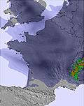 |  | 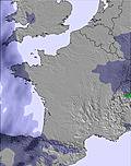 | 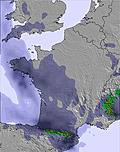 | ||||||||||
— | — | — | — | — | — | — | — | — | — | — | — | — | — | — | — | |
mm | 3 | — | — | 1 | — | — | — | — | — | 1 | — | — | 3 | — | 11 | 2 |
max °C | 18 | 21 | 22 | 18 | 19 | 21 | 19 | 19 | 20 | 18 | 19 | 20 | 16 | 18 | 20 | 17 |
min °C | 15 | 19 | 21 | 17 | 18 | 20 | 17 | 17 | 20 | 16 | 16 | 19 | 16 | 16 | 13 | 14 |
chill °C | 15 | 19 | 21 | 17 | 18 | 20 | 17 | 17 | 20 | 16 | 16 | 19 | 16 | 16 | 13 | 14 |
Humid % | 40 | 35 | 39 | 43 | 42 | 37 | 46 | 37 | 49 | 53 | 42 | 52 | 49 | 49 | 79 | 63 |
Freeze m | 4700 | 4600 | 4650 | 4600 | 4450 | 4600 | 4550 | 4500 | 4600 | 4600 | 4550 | 4550 | 4550 | 4500 | 4350 | 4500 |
— | 6:13 | — | — | 6:13 | — | — | 6:13 | — | — | 6:13 | — | — | 6:15 | — | — | |
— | — | — | 9:31 | — | — | 9:32 | — | — | 9:32 | — | — | 9:32 | — | — | 9:32 | |
Go pro and carve into:
Avalanche information: European Avalanche Warning Services (EAWS)
Latest snow reports near Formigueres:
| Top snow depth: | — |
|---|---|
| Bottom snow depth: | — |
| Fresh snowfall depth: | — |
| Last snowfall: | 17 May 2026 |
| Snow Alerts | Create Alert |
0.0 | Bluebird Powder days Fresh snow, mostly sunny, light wind. |
|---|---|
0.0 | Powder days Fresh snow, limited sun, any wind. |
0.0 | Bluebird days Average snow, mostly sunny, light wind. |
The above table gives the weather forecast for Formigueres at the specific elevation of 2075 m. Our sophisticated weather models allow us to provide snow forecasts for the top, middle and bottom ski stations of Formigueres. To access the weather forecasts for the other elevations, use the tab navigation above the table. For a wider view of the weather, check out the Weather Map of France.
Click here to read further information on freezing levels and how we forecast our temperatures.
Overall 3.6 Based on 3 votes and 5 reviews
My kids just love this place (10 and 11). We have skied the Capcir region twice a year for the last 5 years and will be there again this half-term. Whilst it may not be the most challeging area there is more than enough to keep the novice progressing up to some challenging Reds. When the sun shines (many slopes face southeast) this small area can get quite sugary late in the afternoon and bare patches come through quickly (it's not quite as snowsure as the 3 Valleys) .........but if you ski the top runs it can still be quite lovely.
Adrian Hands from United Kingdom writes:
My kids just love this place (10 and 11). We have skied the Capcir region twice a year for the last 5 years and will be there again this half-term. Whilst it may not be the most challeging area there is more than enough to keep the novice progressing up to some challenging Reds. When the sun shines (many slopes face southeast) this small area can get quite sugary late in the afternoon and bare patches come through quickly (it's not quite as snowsure as the 3 Valleys) .........but if you ski the top runs it can still be quite lovely.


 Nearest