


Global Weekly Snow Roundup #314
Weekly Global Snow News, updated 14 May 2026: Fresh snowfall in Argentina, Australia and Lesotho signals winter’s approach, while Japan maintains the world’s deepest snowpack.

Next 4 days weather summary:A moderate fall of snow, heaviest on Sat afternoon. Freeze-thaw conditions (max 3°C on Mon afternoon, min -8°C on Sat night). Wind will be generally light. | Days 5-7 weather summary:Mostly dry. Freeze-thaw conditions (max 11°C on Thu afternoon, min -2°C on Mon night). Winds increasing (calm on Tue night, fresh winds from the W by Thu afternoon). | |||||||||||||||
Saturday 16 | Sunday 17 | Monday 18 | Tuesday 19 | Wednesday 20 | ||||||||||||
night | AM | PM | night | AM | PM | night | AM | PM | night | AM | PM | night | AM | PM | night | |
light snow | light snow | light snow | snow shwrs | light snow | light snow | snow shwrs | some clouds | snow shwrs | snow shwrs | some clouds | cloudy | some clouds | some clouds | cloudy | some clouds | |
km/h | ||||||||||||||||
Snow map |  |  | 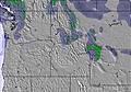 | 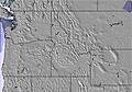 |  |  | ||||||||||
1 | 2 | 3 | 1 | 1 | 2 | — | — | — | — | — | — | — | — | — | — | |
— | — | — | — | — | — | — | — | — | — | — | — | — | — | — | — | |
max °C | 1 | -2 | -1 | -4 | -4 | -3 | -5 | 0 | 3 | 1 | 3 | 6 | 3 | 5 | 9 | 6 |
min °C | -3 | -3 | -3 | -8 | -5 | -3 | -7 | -3 | 2 | -2 | 1 | 5 | 0 | 3 | 8 | 4 |
-6 | -7 | -10 | -13 | -8 | -8 | -12 | -7 | -1 | -5 | -2 | 2 | -3 | 1 | 6 | 0 | |
63 | 93 | 87 | 85 | 86 | 87 | 90 | 67 | 49 | 79 | 67 | 35 | 71 | 68 | 42 | 60 | |
2250 | 1900 | 2100 | 1000 | 1650 | 1900 | 1350 | 1850 | 2500 | 2000 | 2400 | 2850 | 2500 | 2600 | 3200 | 3200 | |
— | 5:58 | — | — | 5:58 | — | — | 5:56 | — | — | 5:54 | — | — | 5:54 | — | — | |
— | — | — | 9:00 | — | — | 9:00 | — | — | 9:01 | — | — | 9:02 | — | — | 9:04 | |
Latest snow reports near Discovery Ski Area:
| Top snow depth: | — |
|---|---|
| Bottom snow depth: | — |
| Fresh snowfall depth: | 1 cm |
| Last snowfall: | 13 May 2026 |
| Snow Alerts | Create Alert |
0.0 | Bluebird Powder days Fresh snow, mostly sunny, light wind. |
|---|---|
0.5 | Powder days Fresh snow, limited sun, any wind. |
0.1 | Bluebird days Average snow, mostly sunny, light wind. |
The above table gives the weather forecast for Discovery Ski Area at the specific elevation of 2286 m. Our sophisticated weather models allow us to provide snow forecasts for the top, middle and bottom ski stations of Discovery Ski Area. To access the weather forecasts for the other elevations, use the tab navigation above the table. For a wider view of the weather, check out the Weather Map of United States.
Click here to read further information on freezing levels and how we forecast our temperatures.
Overall 3.1 Based on 2 votes and 2 reviews
Great hill with lots of terrain for all levels. Terrific value and never any lift lines more than a minute or two. They have a great hill at a great value and they know it. Snobbish, unhelpful people operating it (not all but, enough to notice when you run into one. I didn't know you could power trip selling lift tickets, they showed me that you can).
Skibum from United States writes:
Great hill with lots of terrain for all levels. Terrific value and never any lift lines more than a minute or two. They have a great hill at a great value and they know it. Snobbish, unhelpful people operating it (not all but, enough to notice when you run into one. I didn't know you could power trip selling lift tickets, they showed me that you can).
Read 1 more reviews of Discovery Ski Area or submit your own


 Nearest