


Global Weekly Snow Roundup #314
Weekly Global Snow News, updated 14 May 2026: Fresh snowfall in Argentina, Australia and Lesotho signals winter’s approach, while Japan maintains the world’s deepest snowpack.

Next 3 days weather summary:Mostly dry. Very mild (max 15°C on Sat afternoon, min 9°C on Sat night). Wind will be generally light. | Days 4-6 weather summary:Mostly dry. Very mild (max 15°C on Thu morning, min 9°C on Tue night). Wind will be generally light. | ||||||||||||||||
Sat 16 | Sunday 17 | Monday 18 | Tuesday 19 | Wednesday 20 | Thursday 21 | ||||||||||||
PM | night | AM | PM | night | AM | PM | night | AM | PM | night | AM | PM | night | AM | PM | night | |
some clouds | some clouds | clear | clear | some clouds | cloudy | cloudy | cloudy | cloudy | cloudy | some clouds | some clouds | clear | clear | some clouds | some clouds | some clouds | |
km/h | |||||||||||||||||
Snow map | 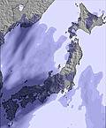 | 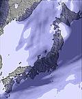 | 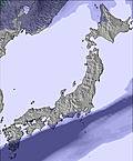 | 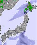 | 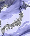 |  | |||||||||||
— | — | — | — | — | — | — | — | — | — | — | — | — | — | — | — | — | |
— | — | — | — | — | — | — | — | — | — | — | — | — | — | — | — | — | |
max °C | 15 | 11 | 13 | 12 | 10 | 15 | 15 | 12 | 11 | 11 | 10 | 14 | 13 | 10 | 15 | 14 | 10 |
min °C | 13 | 9 | 11 | 10 | 9 | 13 | 13 | 10 | 11 | 10 | 9 | 13 | 12 | 9 | 14 | 12 | 9 |
11 | 7 | 10 | 9 | 7 | 11 | 11 | 8 | 8 | 8 | 9 | 13 | 12 | 8 | 14 | 12 | 7 | |
68 | 92 | 64 | 67 | 84 | 64 | 53 | 90 | 79 | 71 | 61 | 50 | 47 | 52 | 39 | 53 | 52 | |
3500 | 3250 | 4000 | 3950 | 3250 | 3500 | 3550 | 3550 | 2850 | 2900 | 2750 | 2600 | 2550 | 2600 | 2800 | 2950 | 3000 | |
— | — | 4:13 | — | — | 4:11 | — | — | 4:11 | — | — | 4:09 | — | — | 4:09 | — | — | |
6:53 | — | — | 6:54 | — | — | 6:55 | — | — | 6:57 | — | — | 6:58 | — | — | 6:59 | — | |
Latest snow reports near Chisenupurri:
| Top snow depth: | — |
|---|---|
| Bottom snow depth: | — |
| Fresh snowfall depth: | — |
| Last snowfall: | 4 May 2026 |
| Snow Alerts | Create Alert |
0.0 | Bluebird Powder days Fresh snow, mostly sunny, light wind. |
|---|---|
0.0 | Powder days Fresh snow, limited sun, any wind. |
0.0 | Bluebird days Average snow, mostly sunny, light wind. |
The above table gives the weather forecast for Chisenupurri at the specific elevation of 691 m. Our sophisticated weather models allow us to provide snow forecasts for the top, middle and bottom ski stations of Chisenupurri. To access the weather forecasts for the other elevations, use the tab navigation above the table. For a wider view of the weather, check out the Weather Map of Japan.
Click here to read further information on freezing levels and how we forecast our temperatures.
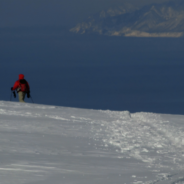
Chisenupurri is pretty sweet for a single day of skiing, but there is, simply, not enough terrain for anything more. That said, it's a great spot, a little flat in places but there's always untracked powder. Make sure you don't go on a big powder day, as you won't be able to go downhill! We were knee to thigh deep and it was great.
Joe from Australia writes:
Chisenupurri is pretty sweet for a single day of skiing, but there is, simply, not enough terrain for anything more.
That said, it's a great spot, a little flat in places but there's always untracked powder. Make sure you don't go on a big powder day, as you won't be able to go downhill! We were knee to thigh deep and it was great.


 Nearest