
Ski Hire by Intersport
Click here for discount

Chandolin Weather (Next 3 days): The snow forecast for Chandolin is: Light rain (total 4.0mm), mostly falling on Sat night. Freeze-thaw conditions (max 11°C on Mon afternoon, min 0°C on Sat morning). Wind will be generally light.
Chandolin Weather (Days 4-6): Heavy rain (total 34.0mm), heaviest during Thu night. Later becoming colder with a dusting of snow on Thu night. Freeze-thaw conditions (max 11°C on Tue afternoon, min 0°C on Thu night). Wind will be generally light.
| Resort | Snow Depth | Temp. (°C) | Wind (km/h) | Weather | ||
|---|---|---|---|---|---|---|
| Top Lift: | 0.0 m | -7 | ||||
| Middle Lift: | -4 | |||||
| Bottom Lift: | 0.0 m | -3 |
Latest snow reports near Chandolin:
Snow crystals reported from Jungfrau Mountain at 3576 metres elevation 7 kms E of Mürren but it is probably falling as rain at the bottom of the ski area from Mürren
A sunny start with great snow and warmer. Wixi and nordwand open. from Wengen

Saturday 27 | Sunday 28 | Monday 29 | Tuesday 30 | Wednesday 1 | Thursday 2 | Friday 3 | |||||||||||||||
AM | PM | night | AM | PM | night | AM | PM | night | AM | PM | night | AM | PM | night | AM | PM | night | AM | PM | night | |
clear | cloudy | light snow | light rain | light rain | some clouds | clear | some clouds | some clouds | rain shwrs | rain shwrs | rain shwrs | light rain | light rain | mod. rain | light rain | mod. rain | light snow | light snow | some clouds | some clouds | |
km/h | |||||||||||||||||||||
Snow map |  |  |  |  |  |  |  | ||||||||||||||
— | — | — | — | — | — | — | — | — | — | — | — | — | — | — | — | — | 1.0 | — | — | — | |
— | — | 1.0 | 1.0 | 2.0 | — | — | — | — | 1.0 | 1.0 | 3 | 3 | 2.0 | 6 | 4 | 8 | 6 | — | — | — | |
max°C | 5 | 7 | 2 | 5 | 7 | 3 | 9 | 11 | 6 | 8 | 11 | 6 | 5 | 6 | 5 | 4 | 4 | 2 | 4 | 8 | 6 |
min°C | 0 | 4 | 1 | 2 | 5 | 0 | 3 | 10 | 2 | 5 | 11 | 3 | 4 | 6 | 4 | 3 | 3 | 0 | 0 | 6 | 1 |
-3 | 2 | -2 | -1 | 3 | -3 | 1 | 9 | -1 | 3 | 10 | 1 | 3 | 5 | 4 | 3 | 3 | 0 | 0 | 6 | -1 | |
61 | 71 | 88 | 74 | 79 | 76 | 60 | 61 | 82 | 79 | 65 | 86 | 94 | 91 | 99 | 98 | 98 | 99 | 78 | 61 | 75 | |
2200 | 2300 | 2050 | 2500 | 2500 | 2250 | 2850 | 2850 | 2700 | 2850 | 2900 | 2700 | 2600 | 2700 | 2500 | 2400 | 2350 | 1900 | 2250 | 2550 | 2450 | |
6:20 | — | — | 6:20 | — | — | 6:18 | — | — | 6:16 | — | — | 6:15 | — | — | 6:13 | — | — | 6:11 | — | — | |
— | — | 8:32 | — | — | 8:34 | — | — | 8:36 | — | — | 8:37 | — | — | 8:37 | — | — | 8:39 | — | — | 8:40 | |
Light rain (total 4.0mm), mostly falling on Sat night. Freeze-thaw conditions (max 11°C on Mon afternoon, min 0°C on Sat morning). Wind will be generally light.
Heavy rain (total 34.0mm), heaviest during Thu night. Later becoming colder with a dusting of snow on Thu night. Freeze-thaw conditions (max 11°C on Tue afternoon, min 0°C on Thu night). Wind will be generally light.
Latest snow reports near Chandolin:
Snow crystals reported from Jungfrau Mountain at 3576 metres elevation 7 kms E of Mürren but it is probably falling as rain at the bottom of the ski area from Mürren
A sunny start with great snow and warmer. Wixi and nordwand open. from Wengen
| Top snow depth: | 0 cm |
|---|---|
| Bottom snow depth: | 0 cm |
| Fresh snowfall depth: | 1 cm |
| Last snowfall: | 26 Apr 2024 |
| Snow Alerts | Create Alert |
0.0 | Bluebird Powder days Fresh snow, mostly sunny, light wind. |
|---|---|
0.6 | Powder days Fresh snow, limited sun, any wind. |
0.0 | Bluebird days Average snow, mostly sunny, light wind. |


The above table gives the weather forecast for Chandolin at the specific elevation of 1650 m. Our sophisticated weather models allow us to provide snow forecasts for the top, middle and bottom ski stations of Chandolin. To access the weather forecasts for the other elevations, use the tab navigation above the table. For a wider view of the weather, check out the Weather Map of Switzerland.
Click here to read further information on freezing levels and how we forecast our temperatures.
Overall 3.9 Based on 4 votes and 3 reviews
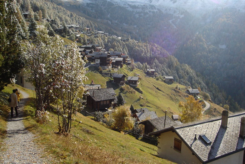
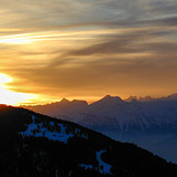
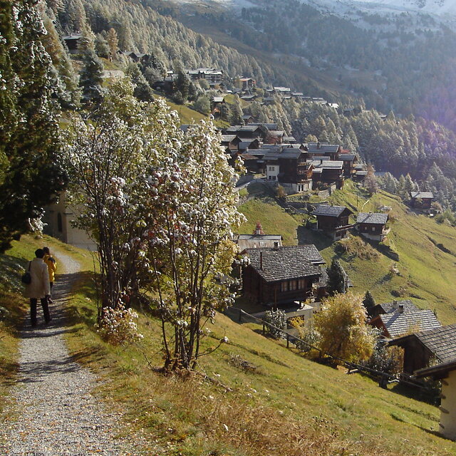
Chandolin is a sleepy little village located high on a sunny bench, precariously perched above the Val d'Anniviers. The ski area is shared with St. Luc, a bigger village with better lift access a few k's back along the road. Since Chandolin is arguably the highest village in Switzerland the road can be very slippery, especially after sunny afternoons have allowed a bit of runoff. The resort is tiny, nightlife non-existent and the lifts are antiquated yet it is still one of my favorite places in Switzerland. The combined ski area is respectably big, invariably quiet, sunny, and after new snow, the off-pitse is excellent. Lack of crowds mean that it can stay that way for several days, especially through the trees. Views are spectacular and lift tickets reasonably affordable. The old part of the village is especially picturesque. All in all it is an excellent place from which to explore the diverse and largely undiscovered slopes of the Anniviers Valley. It is helpful to have your own transport if that's your plan.
Rob from United Kingdom writes:
Chandolin is a sleepy little village located high on a sunny bench, precariously perched above the Val d'Anniviers. The ski area is shared with St. Luc, a bigger village with better lift access a few k's back along the road. Since Chandolin is arguably the highest village in Switzerland the road can be very slippery, especially after sunny afternoons have allowed a bit of runoff.
The resort is tiny, nightlife non-existent and the lifts are antiquated yet it is still one of my favorite places in Switzerland. The combined ski area is respectably big, invariably quiet, sunny, and after new snow, the off-pitse is excellent. Lack of crowds mean that it can stay that way for several days, especially through the trees. Views are spectacular and lift tickets reasonably affordable. The old part of the village is especially picturesque. All in all it is an excellent place from which to explore the diverse and largely undiscovered slopes of the Anniviers Valley. It is helpful to have your own transport if that's your plan.
The Chandolin skiing weather widget is available to embed on external websites free of charge. It provides a daily summary of our Chandolin snow forecast and current weather conditions. Simply go to the feed configuration page and follow the 3 simple steps to grab the custom html code snippet and paste it into your own site. You can choose the snow forecast elevation (summit, mid-mountain or bottom lift) and metric/imperial units for the snow forecast feed to suit your own website…. Click here to get the code.
View detailed snow forecast for Chandolin at:
snow-forecast.com


 Nearest