

Portillo Re-Opens To Guests Arriving By Helicopter
Chile’s famous Portillo ski resort is reported to have re-opened to guests arriving by helicopter after being cut off by road for more than two weeks by over 6m/20 feet of snowfall.

Next 3 days weather summary:Heavy rain (total 47.0mm), heaviest during Mon night. Warm (max 29°C on Mon afternoon, min 16°C on Mon night). Wind will be generally light. | Days 4-6 weather summary:Moderate rain (total 11.0mm), heaviest on Thu afternoon. Warm (max 24°C on Thu morning, min 14°C on Thu night). Wind will be generally light. | |||||||||||||||||
Monday 3 | Tuesday 4 | Wednesday 5 | Thursday 6 | Friday 7 | Saturday 8 | |||||||||||||
AM | PM | night | AM | PM | night | AM | PM | night | AM | PM | night | AM | PM | night | AM | PM | night | |
clear | t-storm risk | rain shwrs | clear | t-storm risk | rain shwrs | clear | rain shwrs | rain shwrs | clear | mod. rain | rain shwrs | some clouds | some clouds | clear | clear | clear | clear | |
km/h | ||||||||||||||||||
Snow map |  |  |  |  |  |  | ||||||||||||
— | — | — | — | — | — | — | — | — | — | — | — | — | — | — | — | — | — | |
mm | — | 4 | 18 | — | 13 | 10 | — | 1 | 1 | — | 9 | 2 | — | — | — | — | — | — |
max °C | 28 | 29 | 18 | 24 | 26 | 17 | 24 | 26 | 22 | 24 | 21 | 17 | 18 | 21 | 19 | 21 | 24 | 20 |
min °C | 20 | 22 | 16 | 18 | 18 | 16 | 18 | 25 | 16 | 19 | 18 | 14 | 15 | 19 | 14 | 16 | 24 | 15 |
chill °C | 20 | 22 | 16 | 18 | 18 | 16 | 18 | 25 | 16 | 19 | 18 | 14 | 15 | 19 | 14 | 16 | 24 | 15 |
Humid % | 37 | 69 | 70 | 55 | 86 | 72 | 53 | 47 | 63 | 56 | 96 | 92 | 82 | 68 | 74 | 57 | 40 | 50 |
Freeze m | 4550 | 4400 | 4500 | 4500 | 4350 | 4400 | 4300 | 4350 | 4400 | 4300 | 4300 | 4150 | 4150 | 4250 | 4350 | 4300 | 4200 | 4250 |
6:16 | — | — | 6:16 | — | — | 6:18 | — | — | 6:18 | — | — | 6:20 | — | — | 6:22 | — | — | |
— | — | 9:00 | — | — | 8:59 | — | — | 8:58 | — | — | 8:55 | — | — | 8:54 | — | — | 8:53 | |
Go pro and carve into:
Avalanche information: European Avalanche Warning Services (EAWS)
Latest snow reports near Champéry:
| Top snow depth: | 122 cm |
|---|---|
| Bottom snow depth: | 93 cm |
| Fresh snowfall depth: | — |
| Last snowfall: | 16 May 2026 |
| Snow Alerts | Create Alert |
0.0 | Bluebird Powder days Fresh snow, mostly sunny, light wind. |
|---|---|
0.0 | Powder days Fresh snow, limited sun, any wind. |
0.0 | Bluebird days Average snow, mostly sunny, light wind. |

The above table gives the weather forecast for Champéry at the specific elevation of 1040 m. Our sophisticated weather models allow us to provide snow forecasts for the top, middle and bottom ski stations of Champéry. To access the weather forecasts for the other elevations, use the tab navigation above the table. For a wider view of the weather, check out the Weather Map of Switzerland.
Click here to read further information on freezing levels and how we forecast our temperatures.
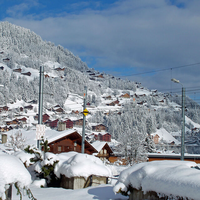
Resort name is also written as Champery.
Overall 4.1 Based on 20 votes and 12 reviews
Have been to Champery over the last six years or so and have never skied such a large linked resort. You can spend most of a week there and hardly ski the same run twice. The village itself is quiet, even in high season; it feels fairly empty and you don't see many youngsters about 'till gone midnight. That said, there is plenty of places to get a few beers! You can get two types of lift passes, Swiss side or the Porters de Soleil pass which covers the French resorts which are a little higher with the snow being better if the season is not very snowy. All in all, if you like skiing more than nightlife this is a great place to ski, and if you get the train from Genova, like we do, it follows lake Carman then takes you up the mountains. The scenery is beautiful; no better way to start a ski break.
Ben Amos, bedfordshire from United Kingdom writes:
Have been to Champery over the last six years or so and have never skied such a large linked resort. You can spend most of a week there and hardly ski the same run twice. The village itself is quiet, even in high season; it feels fairly empty and you don't see many youngsters about 'till gone midnight. That said, there is plenty of places to get a few beers!
You can get two types of lift passes, Swiss side or the Porters de Soleil pass which covers the French resorts which are a little higher with the snow being better if the season is not very snowy.
All in all, if you like skiing more than nightlife this is a great place to ski, and if you get the train from Genova, like we do, it follows lake Carman then takes you up the mountains. The scenery is beautiful; no better way to start a ski break.


 Nearest