

Global Weekly Snow Roundup #318
Weekly Snow News for the world, updated 11 June 2026: Australia's season begins, Val d’Isère reopens and major snowfall is forecast for the Andes.

Next 3 days weather summary:Light rain (total 5.0mm), mostly falling on Sun night. Warm (max 23°C on Sat afternoon, min 11°C on Fri morning). Wind will be generally light. | Days 4-6 weather summary:Moderate rain (total 18.0mm), heaviest on Mon afternoon. Warm (max 23°C on Wed afternoon, min 11°C on Mon night). Wind will be generally light. | |||||||||||||||||
Friday 12 | Saturday 13 | Sunday 14 | Monday 15 | Tuesday 16 | Wednesday 17 | |||||||||||||
AM | PM | night | AM | PM | night | AM | PM | night | AM | PM | night | AM | PM | night | AM | PM | night | |
clear | clear | clear | clear | clear | clear | clear | t-storm risk | rain shwrs | t-storm risk | heavy rain | rain shwrs | some clouds | cloudy | rain shwrs | clear | rain shwrs | rain shwrs | |
km/h | ||||||||||||||||||
Snow map | 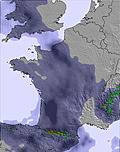 | 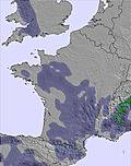 | 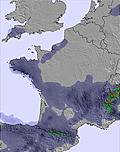 |  |  |  | ||||||||||||
— | — | — | — | — | — | — | — | — | — | — | — | — | — | — | — | — | — | |
— | — | — | — | — | — | — | 1 | 4 | 1 | 11 | 3 | — | — | 1 | — | 1 | 1 | |
max °C | 18 | 21 | 18 | 20 | 23 | 21 | 22 | 23 | 15 | 20 | 17 | 13 | 19 | 20 | 18 | 20 | 23 | 19 |
min °C | 11 | 21 | 12 | 15 | 23 | 14 | 16 | 21 | 12 | 15 | 12 | 11 | 13 | 19 | 13 | 15 | 22 | 14 |
10 | 21 | 12 | 15 | 23 | 14 | 16 | 21 | 12 | 15 | 11 | 11 | 13 | 19 | 13 | 15 | 22 | 14 | |
38 | 30 | 47 | 40 | 32 | 44 | 32 | 46 | 62 | 49 | 82 | 68 | 44 | 49 | 65 | 50 | 46 | 47 | |
4250 | 4250 | 4300 | 4250 | 4300 | 4200 | 4100 | 4300 | 4050 | 3850 | 3850 | 3900 | 3700 | 4000 | 4100 | 4050 | 4350 | 4350 | |
6:18 | — | — | 6:18 | — | — | 6:18 | — | — | 6:18 | — | — | 6:18 | — | — | 6:18 | — | — | |
— | — | 9:35 | — | — | 9:36 | — | — | 9:36 | — | — | 9:37 | — | — | 9:37 | — | — | 9:37 | |
Go pro and carve into:
Avalanche information: European Avalanche Warning Services (EAWS)
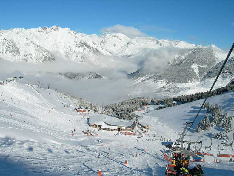
Latest snow reports near Cerler:
| Top snow depth: | 0 cm |
|---|---|
| Bottom snow depth: | 0 cm |
| Fresh snowfall depth: | — |
| Last snowfall: | 15 May 2026 |
| Snow Alerts | Create Alert |
0.0 | Bluebird Powder days Fresh snow, mostly sunny, light wind. |
|---|---|
0.0 | Powder days Fresh snow, limited sun, any wind. |
0.0 | Bluebird days Average snow, mostly sunny, light wind. |
The above table gives the weather forecast for Cerler at the specific elevation of 1504 m. Our sophisticated weather models allow us to provide snow forecasts for the top, middle and bottom ski stations of Cerler. To access the weather forecasts for the other elevations, use the tab navigation above the table. For a wider view of the weather, check out the Weather Map of Spain.
Click here to read further information on freezing levels and how we forecast our temperatures.
Overall 4.0 Based on 61 votes and 28 reviews
Impresentable. Subida de tarifas en forfaits y consumiciones, cancelación de beneficios para familias numerosas (ahora solo si compras un mínimo de 5 días), página de recarga de forfaits caída toda la tarde del viernes 9-2-23, mantenimiento deficiente de remontes (el principal acceso ha estado roto sin funcionar todo el domingo 12 de febrero), desastrosa gestión de la avería (tráfico derivado sin control al parking de Ampriu, no han contemplado las plazas limitadas y han enviado a todo el mundo arriba, generando un caos impresentable). Y se han sacado de la manta un impuesto a revolucionario: ahora hay que “activar” cada temporada el forfait recargable (antes sin coste) por el módico precio de 5€. Unos chapuzas.
Fernando Díaz from Spain writes:
Impresentable. Subida de tarifas en forfaits y consumiciones, cancelación de beneficios para familias numerosas (ahora solo si compras un mínimo de 5 días), página de recarga de forfaits caída toda la tarde del viernes 9-2-23, mantenimiento deficiente de remontes (el principal acceso ha estado roto sin funcionar todo el domingo 12 de febrero), desastrosa gestión de la avería (tráfico derivado sin control al parking de Ampriu, no han contemplado las plazas limitadas y han enviado a todo el mundo arriba, generando un caos impresentable). Y se han sacado de la manta un impuesto a revolucionario: ahora hay que “activar” cada temporada el forfait recargable (antes sin coste) por el módico precio de 5€. Unos chapuzas.


 Nearest