


Global Weekly Snow Roundup #318
Weekly Snow News for the world, updated 11 June 2026: Australia's season begins, Val d’Isère reopens and major snowfall is forecast for the Andes.

Next 4 days weather summary:Moderate rain (total 19.0mm), heaviest on Sun night. Very mild (max 19°C on Fri night, min 8°C on Mon morning). Mainly near gales. | Days 5-7 weather summary:Moderate rain (total 17.0mm), heaviest on Thu morning. Very mild (max 16°C on Wed afternoon, min 8°C on Mon night). Winds increasing (light winds from the NW on Mon night, gales from the SW by Thu afternoon). | |||||||||||||||
Saturday 13 | Sunday 14 | Monday 15 | Tuesday 16 | Wednesday 17 | ||||||||||||
night | AM | PM | night | AM | PM | night | AM | PM | night | AM | PM | night | AM | PM | night | |
rain shwrs | clear | clear | clear | some clouds | cloudy | heavy rain | light rain | cloudy | clear | clear | some clouds | some clouds | clear | some clouds | mod. rain | |
km/h | ||||||||||||||||
Snow map | 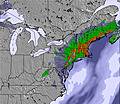 | 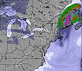 | 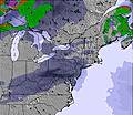 | 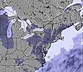 |  |  | ||||||||||
— | — | — | — | — | — | — | — | — | — | — | — | — | — | — | — | |
5 | — | — | — | — | — | 13 | 1 | — | — | — | — | — | — | — | 6 | |
max °C | 19 | 13 | 17 | 16 | 16 | 19 | 14 | 8 | 11 | 10 | 9 | 13 | 12 | 13 | 16 | 14 |
min °C | 12 | 12 | 15 | 14 | 15 | 19 | 11 | 8 | 11 | 8 | 8 | 12 | 10 | 12 | 16 | 12 |
9 | 10 | 13 | 12 | 13 | 18 | 10 | 5 | 10 | 4 | 4 | 10 | 7 | 10 | 14 | 8 | |
74 | 74 | 50 | 57 | 60 | 53 | 100 | 93 | 63 | 63 | 62 | 45 | 65 | 59 | 51 | 89 | |
4300 | 3850 | 3600 | 3600 | 3850 | 3750 | 3650 | 3750 | 3350 | 2950 | 2800 | 2700 | 2750 | 2950 | 3200 | 3500 | |
— | 5:01 | — | — | 5:01 | — | — | 5:01 | — | — | 5:01 | — | — | 5:01 | — | — | |
— | — | — | 8:30 | — | — | 8:30 | — | — | 8:30 | — | — | 8:31 | — | — | 8:31 | |
Go pro and carve into:
Avalanche information: National Avalanche Center
Latest snow reports near Cannon Mountain:
| Top snow depth: | — |
|---|---|
| Bottom snow depth: | — |
| Fresh snowfall depth: | — |
| Last snowfall: | 30 May 2026 |
| Snow Alerts | Create Alert |
0.0 | Bluebird Powder days Fresh snow, mostly sunny, light wind. |
|---|---|
0.0 | Powder days Fresh snow, limited sun, any wind. |
0.0 | Bluebird days Average snow, mostly sunny, light wind. |
The above table gives the weather forecast for Cannon Mountain at the specific elevation of 1274 m. Our sophisticated weather models allow us to provide snow forecasts for the top, middle and bottom ski stations of Cannon Mountain. To access the weather forecasts for the other elevations, use the tab navigation above the table. For a wider view of the weather, check out the Weather Map of United States.
Click here to read further information on freezing levels and how we forecast our temperatures.
Overall 3.6 Based on 19 votes and 9 reviews
Biggest and most challenging mountain in NH. It has a reputation of being icy and cold, because it's often icy and cold. It has a north face so that's what you get. With that you also get incomparable views, incredible terrain, low attendance, tons of snow, and the most challenging terrain in NH. This place is like no other because it's owned by the state, not a pvt. company. Employees are park rangers so don't expect resort treatment, you will not be coddled. It's run like a state operation so there is no urgency or sense that anyone is trying to earn your business. This is a no frills, no fluff, no BS place. People here still wear wool and the attitude is typical New England taciturn. Nestled in Franconia Notch, there's no more majestic setting. The Notch has it's own WX system and it can be snowing in there and sunny and 40 degrees just 5 miles south. It gets more snow than anywhere nearby. The often windy conditions make for frequent "free refills". When hitting fresh powder, you can find your tracks filled in on the next run. With all this heartiness it is still the best learning area that no one seems to know about. The Tuckerbrook section is designated for learners and is accessible yet isolated. It has it's own lift and 6 trails that no advanced skiers go near so the learner has no concerns with traffic. It's also the best value in NH with 2 for 1 liftix on Tues and Thurs. In short, the biggest, baddest, boldest, most unforgiving and most glorious mountain in NH.
Lazlo from United States writes:
Biggest and most challenging mountain in NH. It has a reputation of being icy and cold, because it's often icy and cold. It has a north face so that's what you get. With that you also get incomparable views, incredible terrain, low attendance, tons of snow, and the most challenging terrain in NH.
This place is like no other because it's owned by the state, not a pvt. company. Employees are park rangers so don't expect resort treatment, you will not be coddled. It's run like a state operation so there is no urgency or sense that anyone is trying to earn your business. This is a no frills, no fluff, no BS place. People here still wear wool and the attitude is typical New England taciturn.
Nestled in Franconia Notch, there's no more majestic setting. The Notch has it's own WX system and it can be snowing in there and sunny and 40 degrees just 5 miles south. It gets more snow than anywhere nearby. The often windy conditions make for frequent "free refills". When hitting fresh powder, you can find your tracks filled in on the next run. With all this heartiness it is still the best learning area that no one seems to know about.
The Tuckerbrook section is designated for learners and is accessible yet isolated. It has it's own lift and 6 trails that no advanced skiers go near so the learner has no concerns with traffic. It's also the best value in NH with 2 for 1 liftix on Tues and Thurs.
In short, the biggest, baddest, boldest, most unforgiving and most glorious mountain in NH.


 Nearest