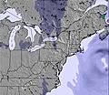
The snow forecast for Cannon Mountain is: Moderate rain (total 10.0mm), heaviest on Sat night. Freeze-thaw conditions (max 11°C on Sat afternoon, min -2°C on Fri morning). Winds increasing (light winds from the SSE on Fri morning, severe gales from the WSW by Sat night).
Cannon Mountain Weather (Next 3 days): The snow forecast for Cannon Mountain is: Moderate rain (total 10.0mm), heaviest on Sat night. Freeze-thaw conditions (max 11°C on Sat afternoon, min -2°C on Fri morning). Winds increasing (light winds from the SSE on Fri morning, severe gales from the WSW by Sat night).
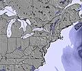
Cannon Mountain Weather (Days 4-6): Moderate rain (total 12.0mm) heaviest on Wed morning, then becoming colder with a dusting of snow on Wed night. Freeze-thaw conditions (max 7°C on Mon night, min -12°C on Wed night). Winds decreasing (severe gales from the SSW on Wed morning, light winds from the W by Wed night).
Issued by Snow-Forecast.com at:6 am (local time) / 06 Mar 2026
Cannon Mountain Weather
(Next 3 days):
The snow forecast for Cannon Mountain is: Moderate rain (total 10.0mm), heaviest on Sat night. Freeze-thaw conditions (max 11°C on Sat afternoon, min -2°C on Fri morning). Winds increasing (light winds from the SSE on Fri morning, severe gales from the WSW by Sat night).
Cannon Mountain Weather (Days 4-6):
Moderate rain (total 12.0mm) heaviest on Wed morning, then becoming colder with a dusting of snow on Wed night. Freeze-thaw conditions (max 7°C on Mon night, min -12°C on Wed night). Winds decreasing (severe gales from the SSW on Wed morning, light winds from the W by Wed night).
Cannon Mountain Weather (Days 7-16):
Interested in the 16-day Forecast? Unlock the full forecast and many more features by becoming a Pro member.
Moderate rain (total 10.0mm), heaviest on Sat night. Freeze-thaw conditions (max 11°C on Sat afternoon, min -2°C on Fri morning). Winds increasing (light winds from the SSE on Fri morning, severe gales from the WSW by Sat night).
Next 4-6 days weather summary:
Moderate rain (total 12.0mm) heaviest on Wed morning, then becoming colder with a dusting of snow on Wed night. Freeze-thaw conditions (max 7°C on Mon night, min -12°C on Wed night). Winds decreasing (severe gales from the SSW on Wed morning, light winds from the W by Wed night).
The above table gives the weather forecast for Cannon Mountain at the specific elevation of 1274 m. Our sophisticated weather models allow us to provide snow forecasts for the top, middle and bottom ski stations of Cannon Mountain. To access the weather forecasts for the other elevations, use the tab navigation above the table. For a wider view of the weather, check out the Weather Map of United States.
Click here to read further information on freezing levels and how we forecast our temperatures.
Biggest and most challenging mountain in NH. It has a reputation of being icy and cold, because it's often icy and cold. It has a north face so that's what you get. With that you also get incomparable views, incredible terrain, low attendance, tons of snow, and the most challenging terrain in NH.
This place is like no other because it's owned by the state, not a pvt. company. Employees are park rangers so don't expect resort treatment, you will not be coddled. It's run like a state operation so there is no urgency or sense that anyone is trying to earn your business. This is a no frills, no fluff, no BS place. People here still wear wool and the attitude is typical New England taciturn.
Nestled in Franconia Notch, there's no more majestic setting. The Notch has it's own WX system and it can be snowing in there and sunny and 40 degrees just 5 miles south. It gets more snow than anywhere nearby. The often windy conditions make for frequent "free refills". When hitting fresh powder, you can find your tracks filled in on the next run. With all this heartiness it is still the best learning area that no one seems to know about.
The Tuckerbrook section is designated for learners and is accessible yet isolated. It has it's own lift and 6 trails that no advanced skiers go near so the learner has no concerns with traffic. It's also the best value in NH with 2 for 1 liftix on Tues and Thurs.
In short, the biggest, baddest, boldest, most unforgiving and most glorious mountain in NH.
Free Snow-Forecast.com weather widget for your website
Embed the Cannon Mountain weather widget on your site for free. It provides a weekly snapshot of snow and rain conditions across all elevations. Follow the two quick steps to grab your custom code and paste it into your site. Choose between metric or imperial units. Click here to get the code.


 Nearest