

Global Weekly Snow Roundup #314
Weekly Global Snow News, updated 14 May 2026: Fresh snowfall in Argentina, Australia and Lesotho signals winter’s approach, while Japan maintains the world’s deepest snowpack.

Next 3 days weather summary:A light covering of new snow, mostly falling on Mon afternoon. Temperatures will be below freezing (max 0°C on Sun afternoon, min -9°C on Sat morning). Wind will be generally light. | Days 4-6 weather summary:A dusting of snow on Tue afternoon. Freezing level rising with drizzle on Wed afternoon. Freeze-thaw conditions (max 8°C on Thu afternoon, min -1°C on Tue morning). Wind will be generally light. | |||||||||||||||||
Saturday 16 | Sunday 17 | Monday 18 | Tuesday 19 | Wednesday 20 | Thursday 21 | |||||||||||||
AM | PM | night | AM | PM | night | AM | PM | night | AM | PM | night | AM | PM | night | AM | PM | night | |
light snow | light snow | snow shwrs | some clouds | some clouds | light snow | light snow | light snow | light snow | cloudy | light snow | light snow | some clouds | rain shwrs | some clouds | some clouds | clear | clear | |
km/h | ||||||||||||||||||
Snow map |  |  |  |  |  |  | ||||||||||||
— | 2 | — | — | — | 1 | — | 3 | 1 | — | 1 | 1 | — | — | — | — | — | — | |
— | — | — | — | — | — | — | — | — | — | — | — | — | 1 | — | — | — | — | |
max °C | -8 | -6 | -5 | -2 | 0 | -1 | -2 | -1 | -2 | 0 | 1 | 1 | 3 | 4 | 4 | 7 | 8 | 8 |
min °C | -9 | -6 | -6 | -3 | -1 | -2 | -2 | -2 | -2 | -1 | 0 | 0 | 1 | 4 | 4 | 5 | 7 | 7 |
-14 | -10 | -10 | -3 | -1 | -4 | -4 | -5 | -5 | -1 | -2 | -2 | -1 | 2 | 2 | 4 | 6 | 6 | |
92 | 92 | 67 | 48 | 77 | 89 | 91 | 92 | 93 | 81 | 97 | 94 | 69 | 83 | 53 | 28 | 58 | 30 | |
1600 | 1900 | 1250 | 2300 | 2600 | 2250 | 2350 | 2300 | 2200 | 2550 | 2650 | 2650 | 2950 | 3100 | 3450 | 3600 | 3600 | 4000 | |
5:58 | — | — | 5:56 | — | — | 5:56 | — | — | 5:54 | — | — | 5:54 | — | — | 5:52 | — | — | |
— | — | 8:57 | — | — | 8:58 | — | — | 8:59 | — | — | 9:00 | — | — | 9:00 | — | — | 9:02 | |
Latest snow reports near Bruson:
| Top snow depth: | 87 cm |
|---|---|
| Bottom snow depth: | — |
| Fresh snowfall depth: | 11 cm |
| Last snowfall: | 15 May 2026 |
| Snow Alerts | Create Alert |
0.1 | Bluebird Powder days Fresh snow, mostly sunny, light wind. |
|---|---|
1.0 | Powder days Fresh snow, limited sun, any wind. |
0.3 | Bluebird days Average snow, mostly sunny, light wind. |
The above table gives the weather forecast for Bruson at the specific elevation of 2578 m. Our sophisticated weather models allow us to provide snow forecasts for the top, middle and bottom ski stations of Bruson. To access the weather forecasts for the other elevations, use the tab navigation above the table. For a wider view of the weather, check out the Weather Map of Switzerland.
Click here to read further information on freezing levels and how we forecast our temperatures.
Overall 3.2 Based on 4 votes and 3 reviews
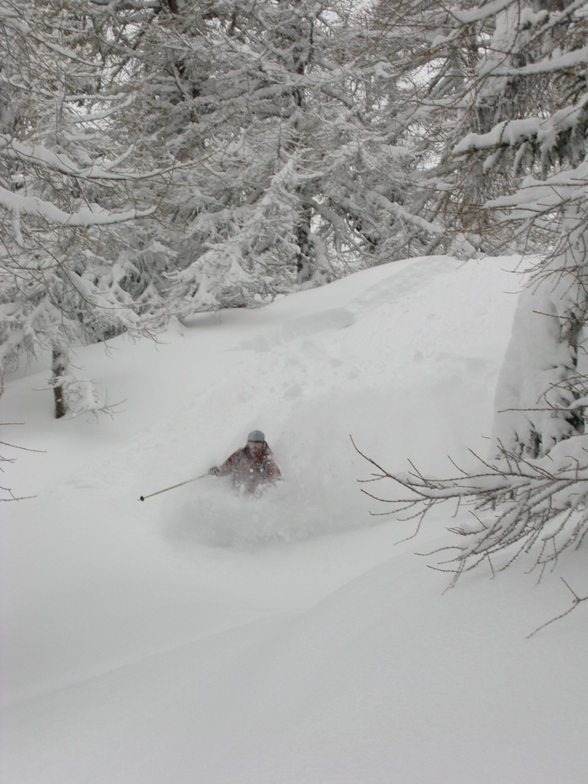
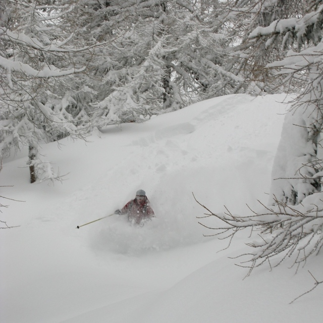
Bruson is a great place to escape the crowds of Verbier on a busy day, especially if there's some fresh powder as it gets tracked out in Verbier about 30 seconds after the lifts have opened. Nice long piste under the main chair and a great itinerary route off the back.
James from Iraq writes:
Bruson is a great place to escape the crowds of Verbier on a busy day, especially if there's some fresh powder as it gets tracked out in Verbier about 30 seconds after the lifts have opened. Nice long piste under the main chair and a great itinerary route off the back.


 Nearest