WORLD SNOW ROUNDUP #279
Issued: 22nd February 2023
By Patrick “Snowhunter” Thorne
World Overview
A fairly quiet week for snowfall across much of the Northern Hemisphere’s ski regions. In fact, base depths have dropped a few centimetres on a week ago and above-freezing temps have been recorded across much of Europe and the Eastern US, where it’s been mostly sunny and dry
The snow has been falling in some areas though, including right across Canada, up in Scandinavia and particularly in the US Rockies as well as in New Mexico where several resorts have reported 2-3 feet (60-90cm) of snowfall in the past week.
In the wider world there has also been heavy snowfall in the Atlas Mountains of North Africa, with complaints from Morocco that roads to the slopes have not been cleared and opened and that ski lifts aren’t functioning anyway.
There have also been the first reported snowfalls of 2023 in the Andes mountains of South America, nearly four months before the ski season is due to get underway there.
Europe
EUROPE INTRO
Sunshine has dominated across western Europe for much of the past week with the daytime freezing point rising to 3,000m at times. The western Alps have seen the most of the sun, with cloud and even light snow showers moving into the eastern Alps over the weekend. For some resorts in the northwestern Alps, it is now over a month since the last significant snow showers, but equally, until the last week it has been very cold and most areas remain in good shape, particularly in terms of terrain open, with the warm weather not yet impacting the extent of slopes open, even though bases remain thin at low elevations. Only low-lying, south-facing slopes have seen a marked drop in cover at resort level over the last seven days. Elsewhere in Europe, the Pyrenees, the Balkans and the Tatras all report similar conditions while northern Europe, Scotland and Scandinavia were stormbound at the end of last week as storm Otto blew through. There’s not a lot open in Scotland still but Scandinavian centres are in good shape on the whole.
AUSTRIA REPORT
Austria had the same sunny weather as the rest of the Alps last week, but since the weekend it has seen cooler temperatures, clouds moving in and some light snowfall. This is similar to what happened a fortnight ago, when Austrian ski areas had a week of snow showers. Whole ski areas had cloudless skies further west in France, but so far it has not been so cold or snowy. Some areas have had 10-20cm (4-8 inch) accumulations through the week and are in better shape for it. Other small low-lying centres have unfortunately seen periods of rain down on lower slopes and at the resort level. All in all, it’s a fairly positive picture across Austria though with colder, snowier weather forecast and most ski centres still with all or most of their slopes open.
AUSTRIA FORECAST
Fluctuating forecasts for Austria with a trend of promising-looking models 4 or 5 days out turning to less snow than expected as the forecast date draws closer. But, that said, we’re currently looking at midweek snowfalls, a bit of end-of-week sunshine and then more snowfall at the weekend, all being well. Slopes above 2000m staying sub-zero around the clock, and freeze-thaw at lower elevations.
SWITZERLAND REPORT
Swiss ski areas have seen mostly sunny skies for the past week, with temperatures climbing into double figures at lower elevations in the afternoons. As with the rest of Europe, despite rather thin bases, there’s not been a lot of impact on the amount of terrain open in Swiss areas, which remains at 80-90%. The only places hard hit are, for example, Crans Montana (30/80cm / 12/32″), which gets the full sun and has seen snow melt away from its resorts streets, although it kept its slopes above open. There has been a little cloudier, cooler weather creeping into Switzerland from the north and east but it has not yet delivered any measurable snowfall.
SWITZERLAND FORECAST
A midweek front moving across the country on Wednesday/Thursday is expected to bring cooler weather and perhaps 10-20cm (4-8”) of snowfall before the return of sunnier conditions to end the week.
FRANCE REPORT
It has been another week of sunshine in the French Alps, with some more northerly ski areas not having seen fresh snowfall for over five weeks now. Daytime highs of +10 or even +12C down at lower lying resorts have led to an early freeze-thaw cycle developing. But despite cover dropping to 20 or 30cm (8-12″) at some of the ski areas that made the headlines at the start of January for not having enough snow to open, so far most resorts have managed to maintain their open terrain at 80-95%. Les Portes du Soleil, for example, with the slopes of Morzine, Avoriaz, Les Gets, Châtel and, over the Swiss border, Champéry, still has about 90% of its terrain open with a 30-90cm (1-3 feet) base. The freeze-thaw does mean it has been getting a bit sticky on low slopes in the afternoons with a hard, icy surface early on in shaded areas. But the avalanche risk is down to 1-2 in most places if you can still find any off-piste powder.
FRANCE FORECAST
There’s finally some change in the air forecast for French resorts with, hopefully, fairly significant snow forecast from the latter half of this week and temperatures dropping back below freezing to low levels, potentially -15 to -20 up at 3,000m by the weekend.
ITALY REPORT
A small return to the scenario a fortnight ago when northeastern Italy saw some good snowfall while the west stayed sunny. The west remained sunny but the past few days have seen cloud and light snowfall returning to Italy’s north-eastern fringes. Sella Nevea (55/230cm / 22/92”), over on the Slovenian border, continues to post Italy’s deepest snow thanks to that early February snowfall, with La Thuile over on the opposite north-western border with France in second place but that is thanks to snowfall back in December and mid-January. As with the rest of the Alps, whether in sunshine or under cloud, temperatures have been climbing in the daytime and most markedly on lower slopes. But the slopes at most Italian resorts remain fully open, or nearly so.
ITALY FORECAST
Cloud expected to move across Italy from Wednesday with snow falling from Thursday on and temperatures dropping back down below freezing right down to the valley floor. 20-50cm (8-20”) accumulations possible by the weekend, in other words a return to winter.
GERMANY REPORT
Germany has been one of the most heavily impacted nations by the warm and dry conditions that have dominated the Alps so far this winter and after good snowfalls at the start of February greatly improved the lack lustre conditions in December and February. Its low-lying ski areas have been hit harder than most by the return of warmer, sunny weather over the past week. Snow has been distinctly wet and thawing fast down below 1000m altitude. The Zugspitze Glacier (109/109cm / 44/44”) has the country’s deepest snow, although well down on its average February snow depth.
GERMANY FORECAST
A half-promising forecast with cooler temperatures and a mixture of cloudy, sometimes snowy weather and sunny spells. It is getting cooler but the only caveat is that it isn’t getting really cold. So the concern is lower slopes will see rain rather than snow.
SCANDINAVIA FORECAST
The usual mixed picture of sunshine, cloud and snowfalls across Scandinavia with a big variation in temperatures too from daytime highs of +5C at lower-lying resorts down to -20C overnight at more northerly locations.

SCOTLAND REPORT
It is the main half-term week for Scottish schools and those of northern England. However, open terrain is limited at present, unfortunately, and skiers are being advised to book ahead to ensure access to the terrain they can ski or board. The problem continues to be warm temperatures preventing snow accumulation, particularly on lower slopes, despite regular snowfalls continuing higher up. Glenshee (0/20cm / 0/8”) and the Lecht (0/20cm / 0/8”) both posted 10cm (4”) falls at the start of the weekend but said it was not enough to reopen main runs and have skiing only on short areas near the base maintained with all-weather snow-making machines. Glencoe (10/50cm / 4/20”) and Cairngorm (20/40cm / 16/32”) have more natural snow left up high (at the time of writing) for intermediate-advanced skiers.
SCOTLAND FORECAST
No big change forecast for the coming week with temperatures five or ten degrees on either side of freezing and snowfall, rain showers, clouds, sun and wind all in the mix once more.
SPAIN / ANDORRA REPORT
It has been predominantly sunny over the last week in the Pyrenees with similar conditions to the Alps, further north, with temperatures getting well above freezing at lower elevations in the daytime, leading to a decreasing snowpack, staying closer to zero up high. Again, similar to further north, most resorts remain 80-90% open. Andorra’s Grandvalira (20/80cm / 8/32), the region’s largest ski area and home to Pas de la Casa, Grau Roig and Soldeu-El Tarter ski areas, has the most terrain open, about 85% of its maximum extent.
SPAIN / ANDORRA FORECAST
A promising report with the weather already starting to change as we complete this report, with clouds moving in and temperatures dropping. Increasingly heavy snowfall is now expected in the Pyrenees through the remainder of the week.
BULGARIA / ROMANIA REPORT
The sunshine is out and the freezing point rising in the Balkans and Carpathians too, after cold and snowy weather through the first half of February. So with temperatures hitting +10 or 12C at the height of the day at the resort level, it’s freeze-thaw on lower slopes. Pamporovo (74/103cm / 30/41”) has the deepest reported base in the region, Bansko (5/70cm / 2/28”) the most terrain open, now more than 80% of its terrain including the long run back to the resort base.
BULGARIA / ROMANIA FORECAST
Sunny weather continuing through the remainder of this week with perhaps some cloud build-up in the latter half of the week. Not much change is expected in temperatures, still reaching double digits in valleys and a little above freezing on higher slopes by the afternoons.
CZECH REPUBLIC / SLOVAKIA REPORT
After a sunny week last week, the Czech and Slovak Republics have seen much more cloud, cold weather and snowfall than much of the rest of mainland Europe since the weekend with cold weather moving down for the Arctic pegging temperatures at just a few degrees above freezing in the afternoon and dipping well below zero at altitude and the rest of the time at resort level too. In short, it feels much more like winter here. The region’s biggest area, Jasna (50/180cm / 20/72″), has 100% of its slopes open and has seen the fastest-growing snow depth in Europe outside of Scandinavia over the last month. However, operations there have been impacted by strong winds closing lifts in recent days too.
CZECH REPUBLIC / SLOVAKIA FORECAST
The cloudy, snowy, cold weather is forecast to continue in the region through the remainder of this week and at least through the weekend with 20-40cm (8-16”) accumulations possible.
NORTH AMERICA INTRO
A mixed report across North America this week with some great new snowfalls in the west, particularly the Rockies and the Pacific Northwest, but, after the very-cold temperatures earlier this month, an unwelcome return of warm and wet weather to the East Coast and Midwest. So it is cold and powder on the western side of the continent and a bit of a battle to maintain snow quality and quantity in the east, at least in smaller, more southerly areas. Rain has been falling as snow for most centres up in northern New England and Quebec, so great conditions there too.
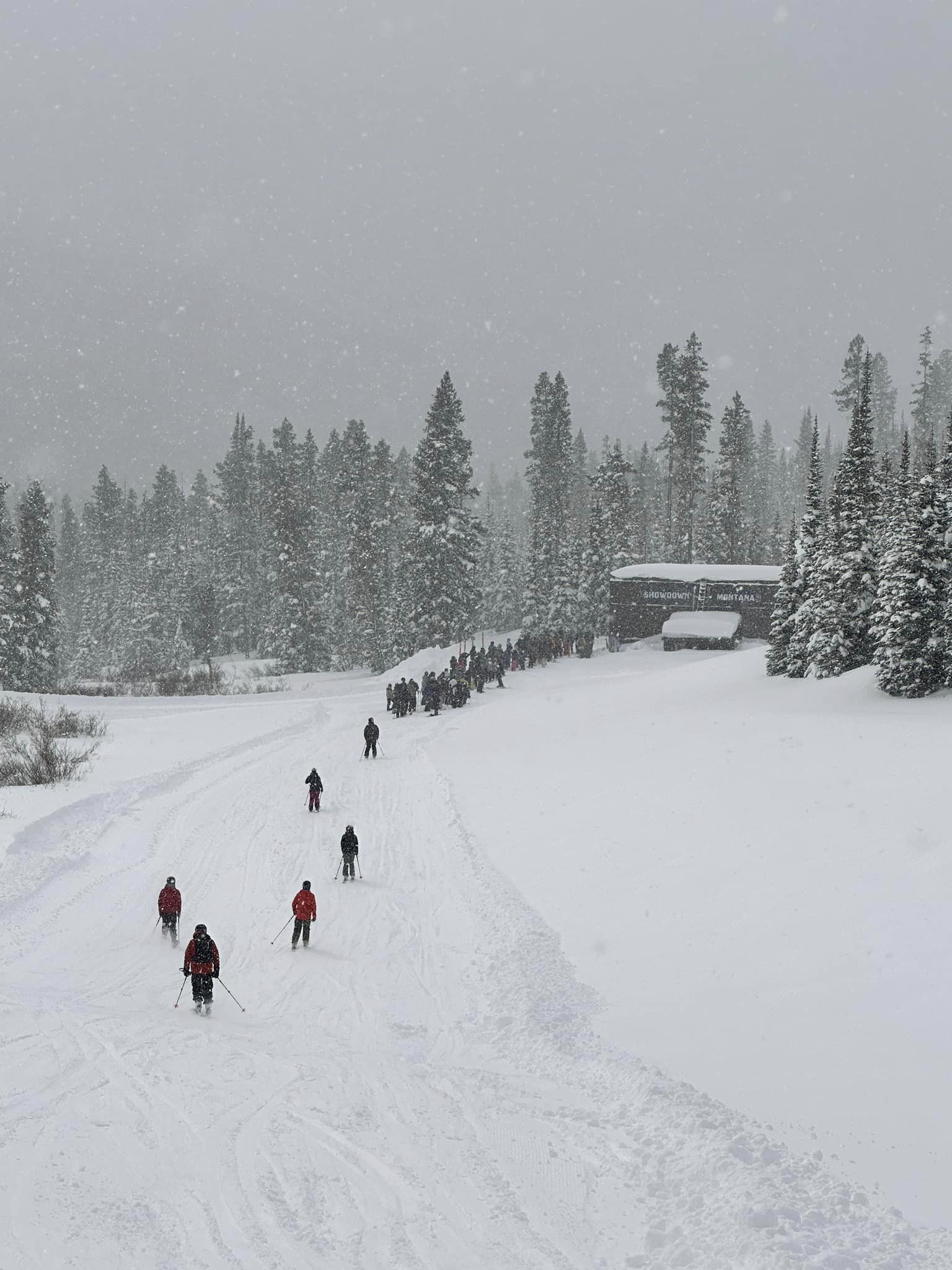
ROCKIES REPORT
Some big snowfalls to end last week in the Rockies with ski areas including Telluride (26/58” / 65/145cm) and Wolf Creek (94/103” / 236/257cm), in Colorado, posting several feet (60cm+) of snowfall going into the weekend and taking the latter through the 100” settled base mark for the first time this season. There was a lot of snow further south in the Sangre de Cristo Mountains too, where Taos in New Mexico posted 25” (63cm) of snowfall in 48 hours. So plenty of powder is to be found at present and most ski areas are 100% open, including America’s biggest, Park City (68/90″ / 170/224cm) in Utah.
ROCKIES FORECAST
The recent snowy weather in the Rockies looks set to continue over the next few days as cold air from the north is expected to bring more significant snowfalls through the remainder of this week.
USA WEST REPORT
Sunshine with snowy spells and temperatures well below freezing day and night have been the main features of the last seven days in the mountains along America’s Pacific Coast. Up in the Pacific Northwest corner around Oregon and Washington state, it has been a little warmer, getting into the low 40s at bases in the afternoons, but it’s been snowier too, with light falls most days. Further north still some ski areas in Alaska have posted three straight weeks of daily snowfall now totalling over eight feet (2.4 metres) of fresh snowfall through February. Mammoth Mountain (152/236″ /381/589cm), down in California, continues to post the world’s deepest base this season. But the spring thaw, or at least a settling snowpack, seems to be beating fresh snow accumulation as it is down about 30 inches on the 22 feet we had measured here a month ago, dropping back below 20 feet.
USA WEST FORECAST
Arctic air moving down into Alaska and the Pacific Northwest will spread across much of western North America bringing unseasonably low temperatures and plenty of snowfall for the latter half of this week.
MIDWEST REPORT
Most of the Midwest has been suffering a well below average winter for snowfall and above average temperatures too and the last week has, on the whole, followed that pattern with rains showers reported at times rather than snow. Only the far north of the region is running at historical average levels of cold and snow. That all being said, resorts have had some snowfall this week and the base depth at the region’s snowiest centre this winter, Boyne Mountain Resort (65/65″ / 160/160cm), in Michigan, is up another five inches. Like most ski areas in the region, it is fully open.
MIDWEST FORECAST
There’s potentially a substantial amount of snowfall expected for parts of the Midwest including Minnesota, Wisconsin and northern Michigan over the next few days thanks to cold weather from the north.
USA EAST REPORT
Unfortunately, we are back to warm weather temperature spikes in the Eastern US, after the cold start to the month, with some smaller, more southerly centres posting rain rather than snow, leading to some areas closing until the weather improves and the remainder battling to keep slopes in pristine condition. Despite some big storms over the past three months, snowfall totals in the region remain well down on the historical average. The big resorts have most of their slopes open still despite thin coverage though, the most at Killington (16/22″ / 40/55cm). Snowshoe (22/51” / 55/127cm), in West Virginia, has the deepest snow in the east.
USA EAST FORECAST
The next few days will see the East Coast split between weather systems, one moving down from the Arctic bringing colder than average air in the north, and another moving up from the Gulf of Mexico bringing warmer than average weather for late February. So ski areas will either see plenty of snow, if they’re on the right side of the divide, or, unfortunately, more warm, wet weather to the south.
CANADA WEST REPORT
A cold and frequently snowy week in Alberta and BC with temperatures typically in the -5 to -25C range, although coastal centres have had their usual above-freezing numbers at base levels. It’s here that Canada’s deepest snow is lying though, now at over 12 feet on Mount Seymour’s (226/366cm / 90/146″) upper slopes. Kicking Horse (90/142cm / 36 57″) hosted the latest round of the 2023 Freeride World Tour at the start of last weekend. But it, or the backcountry next to it to be precise, was also the location of multiple avalanche fatalities with the danger level remaining high across the province as it is expected to remain for the rest of the season.
CANADA WEST FORECAST
Arctic air is moving down into western Canada through the latter half of this week and is expected to bring heavy snowfall and bitterly low temperatures to the region.
CANADA EAST REPORT
Although temperatures are warmer in Quebec and Ontario than the very low numbers reported earlier this month, there has not been the rise back above freezing we saw south of the border. Instead, ski areas in the region have been reporting more snowfalls and some great conditions. The region’s largest resort, Tremblant (54/220cm / 22/88”), is 100% open posting both the most terrain in eastern Canada and the deepest snow.
CANADA EAST FORECAST
Eastern Canada remains north of the North American weather divide for the latter half of this week and is expected to enjoy colder-than-average late February temperatures and more snowfall setting resorts up well for the start of March.
Asia
JAPAN REPORT
Following the snowy weather of just over a week ago, things have warmed up considerably in Japan and there’s been much less snowfall to report and unfortunately, some resorts have actually seen rain instead. There’s also been some clear, sunny weather and many areas are reporting their base depths have dropped a little on last week. Things have improved in the last few days though with temperatures dropping and fresh snowfall. Compared to much of the rest of the world snow depth numbers are fairly impressive with up to 5 metres (17 feet) lying reported. Niseko (150/360cm / 60/144”) has some of the best numbers outside of Western North America.
JAPAN FORECAST
A fairly cold and snowy week ahead forecast with temperatures between freezing and -7C forecast as well as daily snow showers.


