WORLD SNOW ROUNDUP #232

Issued: 16 March 2022
By Patrick “Snowhunter” Thorne
European Roundup
North American Roundup
Asia Roundup
WORLD OVERVIEW
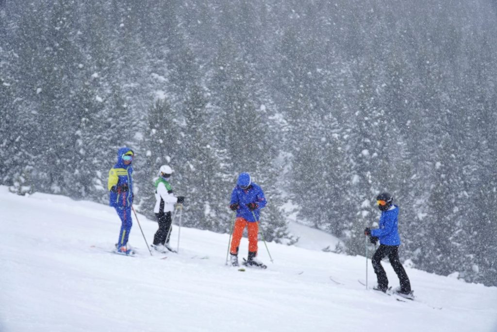
It is something of a déjà-vu report for readers of last week’s edition as we have had the second week of largely sunny weather in the European Alps, but with snowfall down in the Pyrenees, then across in North America more fronts coming across bringing fresh powder for ski areas from West to East coasts.
At the same time though there are signs of change as e move further into springtime (by the meteorological measure of the seasons), with the first ski areas in North America announcing early closure due to an inadequate snowpack to carry on despite recent storms and the world’s deepest reported snow depth, which hit a high of 6m (20 feet) at a resort in Japan a week ago, now dropping back to 5.5m (around 18 feet) s the season turns there too.
Pandemic restrictions also continue to gradually ease around the world making travel a little easier and life in resorts less restrictive, although that’s all happening a little late for this season.
EUROPE INTRODUCTION
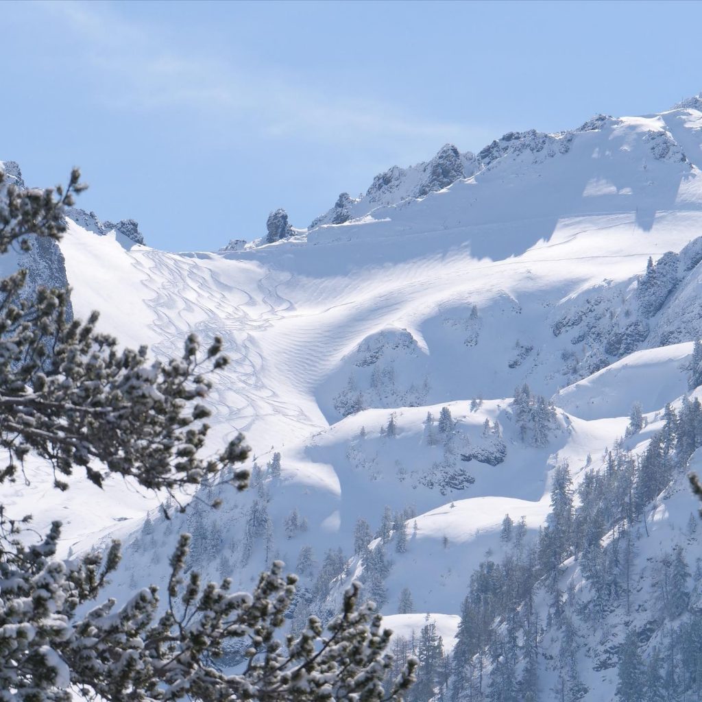
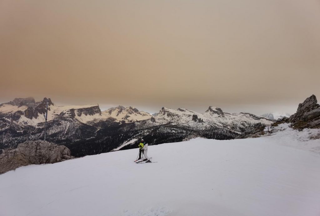
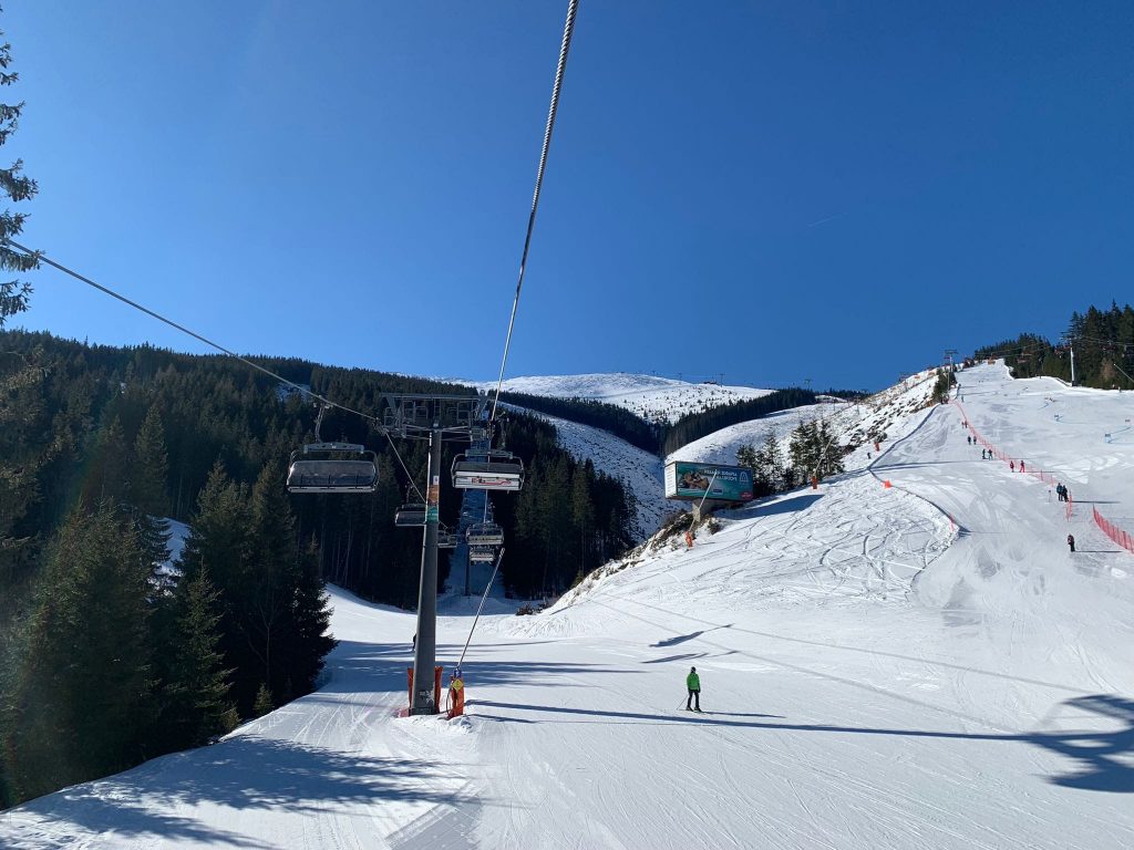
It has been more of the same for much of Europe really with largely sunny skies across the Alps for the second straight week, although centres in the western Alps reported up to (15cm) 6″ of snow to start the week. Generally, though it has been colder and sometimes snowier down in the Pyrenees and the Balkans, unusually, compared to further north. A more unusual feature on Tuesday was low visibility and an orange hue to the air and the snow thanks to fine dust blowing over from the Sahara.
Beyond that, as we move further into March, there’s the inevitable trend towards the end of the season with base depths generally down 5-10% compared to a week ago and less and less snow cover down at valley level. Most centres will aim to stay open at least to the end of March and many major centres for another 5-6 weeks past Easter and mot have plenty of snow to see them through, even though this has not been a particularly good season for snowfall volumes over the past three months.
AUSTRIA
AUSTRIA REPORT The wall to wall sunshine that has dominated Austrian skies the past fortnight has continued and the possibility of a little light snowfall from overcast skies at the weekend did not really materialise. Snow depths remain good across most of the country, at least on higher slopes, but with rising temperatures in the valleys, it does feel at present like the spring thaw is beginning to set in. For some low-lying resorts, there’s really only a few weeks of the season left but then others with high slopes and glacier skiing will be open to May, June and in a few cases later into the summer. The Arlberg region including St. Anton, Lech and Zürs (135/275cm / 54/110”) is currently showing both the deepest snow depth in the country and with 273km (170 miles) of runs skiable, about 90% of its maximum terrain, the largest ski area open too.
AUSTRIA FORECAST The mostly sunny conditions of the last two weeks now look set to continue for at least the rest of this week, with just the odd period of cloud in the forecast. Temperatures will climb further though and some low Austrian valleys could hit +15C in the latter half of this week.
SWITZERLAND REPORT Swiss ski areas have also enjoyed another week of predominantly sunny skies. Temperatures have stayed fairly favourable for snow sustainability at altitude but have been creeping warmer over the past few days with many areas seeing +10 to +15C down at the base of the slopes. Despite this more or less all ski areas ad all groomed runs are open, with the Titis glacier above Engelberg (10/295cm / 4/118”) posting the deepest base in the country and indeed all Europe – if not the 5-6 m (17-20 feet) it usually posts by the start of March.
SWITZERLAND FORECAST Sunny and warm for the net few days but temperatures are forecast to drop away towards the weekend with some snowfall expected in the south and east of the country.
FRANCE REPORT It was a cloudy end to the week in French ski resorts after almost a fortnight of predominantly sunny skies. However, there were just a few light slow flurries for some and nothing for many before the sun returned for most of Sunday. More significant snowfalls on Sunday night brought up to 15cm (6″) more snowfall though and a powder day for some on Monday. Down in the Pyrenees, the clouds lasted longer and the snow showers were a little more substantial. Temperatures have crept up a degree or two on a week ago too so there’s more of a spring feel in resorts with double-digit plus temps in afternoons, staying closer to freezing above 2,000m. Snow cover remains enough though if dropping about 5-10% week-on-week at present, to see out the season at most areas. La Plagne (70/250cm / 28/100”) and La Clusaz (35/250cm / 14/100”) are posting the country’s thickest snowpack.
FRANCE FORECAST The predominantly sunny weather is forecast to continue for the remainder of this week and temperatures in valleys may climb up as high as +15C at around 1,000m altitude so a full spring thaw on low lying slopes. But there are signs of colder weather and some snowfall for many at the weekend.
ITALY REPORT Another dry week for most ski areas in Italy as well, although it was a cloudy weekend for many and there has been a little less sunshine for all that the previous week. Temperatures have been creeping a degree or two higher however with valley temps reaching double-digits above freezing most days now, though still sub-zero above about 2,000m day and night. The cross border areas of Cervinia – Zermatt (0/140cm / 0/56″) with skiing over into Switzerland and the Milky Way (25/50cm / 10/20″) with skiing into France both report about 280km ( 175 miles) of runs open, about 80% of the maximum terrain possible in Cervinia but nearly 65% in the Milky way which has struggled to open all of its runs this season.
ITALY FORECAST It currently looks like there should be some snowfall later this week in the north of the country after a few more dry and sunny days. The general trend toward warmer temperatures continues, however.
GERMANY REPORT It has been a sunny week in Germany and low-lying ski areas have seen some very warm temperatures – as high as +15C for some. So about two-thirds of the country’s smaller, lower-lying centres have already closed for the 21-22 season, although most of the larger, higher, destination resorts will be open into April. The highest of these the Zugspitze (270/270cm / 108/108”), with the longest season to the start of May, reports the country’s deepest base by some distance. Reit im Winkl (37/155cm / 15/62”) has the second deepest. Both have all runs open.
GERMANY FORECAST Sunny and potentially reaching +20C in the afternoon in some low-lying valleys over the next few days. Cooling rapidly towards the weekend with some potentially seeing snow (or rain) from late Saturday and Sunday.
SCANDINAVIA REPORT Unusually it has been dry across almost all of Scandinavia over the past seven days with plenty of sunshine and temperatures in to -10C to+5C range, although not getting above freezing very often. Given the long daylight hours now this makes Scandinavia’s snow conditions about the best in Europe at present for those who seek light powder, notwithstanding the fresh snowfall in the Pyrenees. Åre (40/120cm / 16/48”) which has been hosting World Cup ski racing this past weekend has every run open, the most in the region.
SCANDINAVIA FORECAST It is looking like a dry and sunny end to the week for much of Scandinavia with temperatures ranging between -10 and +5C.
SCOTLAND REPORT The week ahead is largely dry. Overnight lows around freezing in the mountains but daytime highs at +10C or above so not looking good from the thin cover on lower slopes, unfortunately.
SCOTLAND FORECAST After the sunny start to the week more typical March weather looks set to impact Scottish hills over the coming week with cloudy skies, rising temperatures, moderate wind speeds and some precipitation. It is, unfortunately, looking more like rain than snow at present and it remains to be seen if there is more snow on higher slopes and how well the existing snowpack stands up to the coming weather.
SPAIN / ANDORRA REPORT The Pyrenees have been one of the snowier spots in Europe for the second successive week, with more fresh snowfall reported towards the end of last week and continuing through last weekend before skies cleared over the last few days. Not huge falls but successive 5-10cm accumulations certainly helped to improve cover further and give a nice refresh to the slopes. Andorra’s Grandvalira (70/120cm / 28/48”) continues to post the most terrain open with more than 90% of its 240km (150 miles) of slopes groomed and prepped. All other ski areas in the region remain fully open too though.
SPAIN / ANDORRA FORECAST Temperatures should stay close to freezing in the Pyrenees over the coming week, at least up above 1800m or so, below that it will be getting warmer. Clear skies are expected to continue through midweek with plenty of sunshine before a fresh front brings another snow shower to end the week.
BULGARIA / ROMANIA REPORT A drier week in South-eastern Europe after all the snowfall at the end of February and the start of March. Mostly sunny too, but temperatures fluctuating between very cold – double-digits below freezing (-20C up high at the weekend for some), and something closer to freezing. Bansko (50/200cm / 20/80”) continues to post the deepest base in the region and has everything open buy Pamporovo (100/190cm / 40/76”) also has everything open, isn’t far behind on snow depth and has more lying at resort level.
BULGARIA / ROMANIA FORECAST The forecast is for more snowfall to roll in during the latter half of this week as temperatures drop away to well below freezing once more. It’s one of the coldest March’s on record so far.
CZECH REPUBLIC / SLOVAKIA REPORT The Freeride World Tour rolled into Jasna (40/90cm / 16/36”), Slovakia’s largest resort, at the weekend and although there has not been much fresh snowfall in the region over the past seven days, fortunately, protected powder from the previous week gave the world’s best plenty to enjoy and show off their skills on. It has certainly been a more springlike week than recently with plenty of sunshine and daytime highs on high slopes reaching plus five even at altitude and of course much warmer in the valleys, against that overnight low remain well below freezing. CZECH REPUBLIC / SLOVAKIA FORECAST It does look to be mostly sunny for the week ahead with the exception of a front pushing through midweek which looks set to deposit 5-15cm (2-6”) of fresh snowfall on the region’s slopes before clear skies return.
NORTH AMERICA
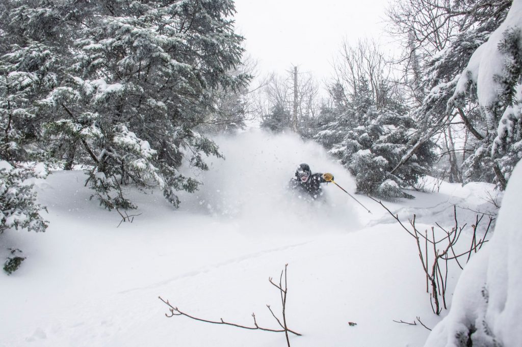
NORTH AMERICA INTRO It has been a second successive snowy eek in North America with first further snowfalls in the west followed by a big weekend storm hitting the Midwest and East, bringing up to a foot (30cm0 of snowfall to ski areas across the country. The snowfall has been accompanied by gales force winds and very low temperatures at times, making for challenging operating conditions for a time, then great powder skiing and boarding as settled weather returns. The fresh snowfall isn’t quite enough to make up for the lack of snowfall for the season overall in some regions though and the first ski area in California to end it’s 21-22 season announced it was calling it a day for the winter at the weekend citing a thin snowpack due to limited snowfall.
ROCKIES REPORT The improved picture in the Rockies has continued for another week with more snowfalls in the region and some cold weather too. Aspen (28/92” / 70/230cm) is the latest ski area to announce it is extending its season by a week, to April 24th, following Vail’s (34/72” / 60/180cm) announcement last week that they’ll go to May 1st.There was 12-24” (30-60cm) more snowfall for most ski resorts in the region in the latter half of last week. Since then a mixture of overcast and sunny skies but not much more snowfall. Park City (47/75″ / 117/175cm) in Utah continues to be fully open with the largest ski area in the US. Wolf Creek (120/136″ / 300/340cm) has the deepest base in the region and one of the deepest in the world this March it’s also 100% open.
ROCKIES FORECAST Another front is moving towards the Rockies imminently and expected to deliver another 6-12″ (15-30cm) of snowfall to most areas on Wednesday/Thursday this week. Temperatures are below freezing from top to bottom of most ski areas but are expected to climb with sunny skies to end the week and continue through the weekend.
USA WEST REPORT Another mixed week of weather in the West with sunny days dominating as usual, but a series of weather fronts coming in, each bringing light to moderate snowfalls to the region. Alyeska (43/168″ / 107/419cm) up in Alaska continues to post the continent’s deepest base (and the deepest base anywhere except Japan), and Timberline (290/360cm) in Oregon where the season aims to continue to September, one of the deepest resort-level bases, as well as the second deepest in North America on its upper runs. But against these positive numbers, there are signs many areas are struggling for decent snow cover. Mt Shasta has become one of the first ski areas in the region to end its season. The resort said it was closing earlier than hoped due mainly to warm weather and a season that saw the snowpack only reach half its average.
USA WEST FORECAST Looking ahead the rest of this week should be sunny with temperatures continuing to be below freezing on the upper mountain but climbing to 10 degrees above down in the resort by the afternoon.
MIDWEST REPORT Although we had a full-on return to winter at the end of last week with low temps and fresh snowfall in the Midwest, the start of this week has seen an increasingly springlike feel to the weather with temperatures climbing back above freezing day and night. Overcast skies primarily with the sun poking through. Wilmot Mountain (64/64” / 160/160cm) is posting the region’s deepest base.
MIDWEST FORECAST Conditions look set to stay springlike with temperatures ranging from freezing up to 10 or 15 degrees above, with the end of the season only a few weeks away now for many of the regions’ areas. Light snowfall is possible in most areas with the Dakotas and Minnesota likely to see some in the next few days, resorts in Michigan and Wisconsin perhaps later in the week, but nothing that significant is expected.
USA EAST REPORT A major storm hit the eastern US at the weekend bringing some of the best powder conditions of the season so far to many ski areas there. The storm was accompanied by strong winds and rain at lower elevations at times which did impact operations at some areas for a time, but overall it was a great boost to cover. Temperatures also dipped way back down to double-digits sub-zero – a brief return to something more like January, but snowier. Smugglers’ Notch (24/48 / 60/120cm) in Vermont is one of the winners from the latest storm and has posted the deepest lying snow in the state. Since the weekend it has been cold, largely dry, but with some areas seeing light snowfall.
USA EAST FORECAST Sunny spells with some cloudy days too through the remainder of this week with temperatures warming. The next front due through Friday/Saturday currently looks like it will be borderline rain/snow depending on latitude and altitude with higher and more northerly slopes more likely to see snow.
CANADA
CANADA WEST REPORT It has been a snowy few days in Western Canada, with some decent dumps for most areas leading in the weekend then more snow falling at many areas at the start of this week too. Temperatures have remained fairly cold too, not getting much above freezing in the mountains in Alberta and inland in BC and only a few degrees warmer down at resort bases. Most ski areas in the region remain fully open and most ski areas are staying open for at least another month, or more than two months in the case of a few like Whistler Blackcomb (20/260cm / 8/104”) and Banff’s Sunshine (60/208m / 24/84”). Kimberley (118/370cm / 47/148”) has the region and Canada’s deepest snowpack.
CANADA WEST FORECAST A mixture of sunny and cloudy skies for the remainder of this week and through the weekend with no snowfall currently in the forecast. Temperatures staying cold (freezing or below on the slopes, daytime highs of +5C down at resort level inland, +8C on the coast).
CANADA EAST REPORT A largely good-news week for skiers and boarders in Eastern Canada with plenty of snowfall going into the weekend and resorts in Ontario and Quebec reporting 15-40m (6-16”) accumulation of fresh snowfall and great powder conditions on Saturday and Sunday. Skies largely cleared from then on and temperatures dropped as low as -20C but have been rising fairly quickly since. Mont Sutton in the south of the region was one of those posting the biggest accumulations. Tremblant (30/305cm / 12/122”) continues to post one of the deepest bases in North America and indeed the world (outside Japan), but it is down a bit over the past few weeks from its 3.4 metre high, signalling the change in the seasons. It continues to have the most terrain open in the region, however. Further east, Mont Ste Anne (35/50cm / 14/20”) has a lot less snow lying but almost as much terrain open.
CANADA EAST FORECAST It is looking fairly dry for the rest of this week although a front arriving t the end of the week is expected to bring more precipitation, Currently, as temperatures are rising, it’s not clear if this will most likely fall as rain or snow.
ASIA
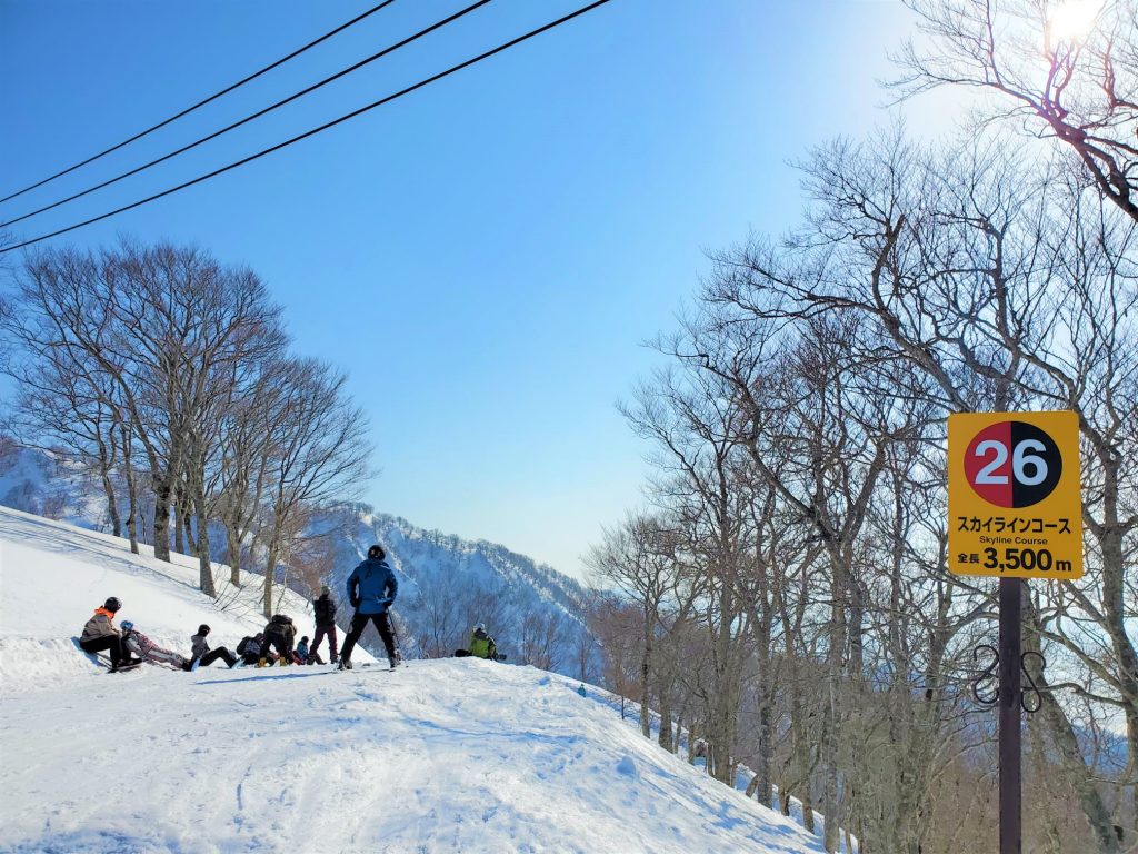
JAPAN REPORT We seem to be past the peak of snow depths in Japan, and probably the world, for 21-22 with ski areas around Myoko which had posted 6 metres (20 feet), snow depths a week ago – the only ones in the world to hit that number (or go past 5m this year), now posting 5.5m (18 feet), a 50cm (20”) drop on a week ago. That reflects warming temperatures, settling snowpack and less fresh snowfall in Japan as spring increases its grip. The county’s sole summer skiing area, Gassan, has announced it’s aiming to open on April 10th this year for its three-month season. Generally, the weather in Japanese ski fields has been creeping closer to freezing. Niseko (195/400cm / 38/160”) has just had a few light snow flurries and its common problem of strong wins closing higher lifts at times. Resorts have also started announcing their target losing date with Niseko saying their final sector closing will be on May 7th.
JAPAN FORECAST More springlike weather forecast with temperatures around freezing, a mix of sunny and cloudy spells, light to moderate wind and occasional snow showers.


