WORLD SNOW ROUNDUP #177
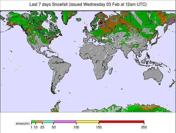
Issued: 03 February 2021
By Patrick “Snowhunter” Thorne
European Roundup
North American Roundup
Asia Roundup
EUROPE INTRODUCTION
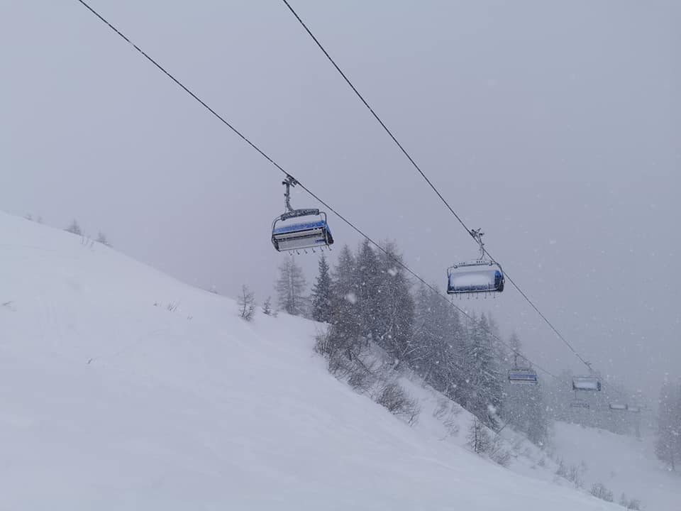
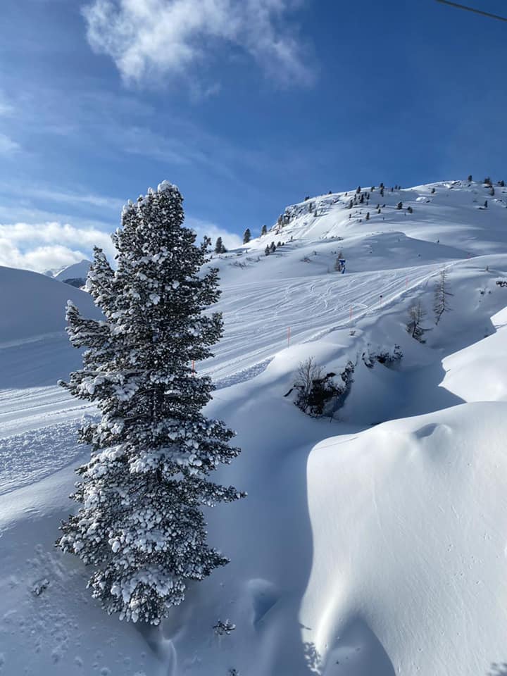
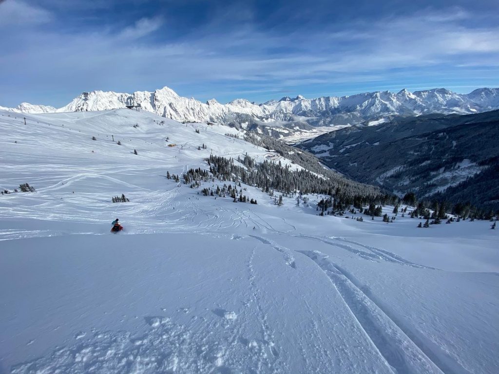
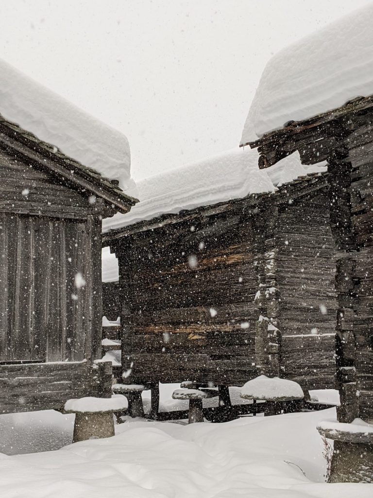
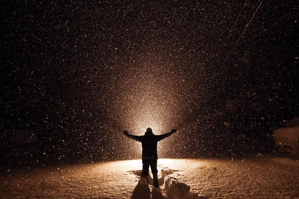
A dramatic week for weather in the Alps. After posting up to 1.5 metres (five feet) accumulations in the previous week for some ski areas in Austria and Switzerland, the snowfall, if anything, intensified in the latter half of last week and heavier snowfall was reported further west in France and Switzerland. Unfortunately, it wasn’t just snow either, temperatures rose into the weekend and rain was reported as high as 2,000 metres altitude. This combination was not good for snow stability and the avalanche danger rose to the maximum level 5 across a wide swathe of the Alps. A number of resorts, including Zermatt, were cut-off from the outside world for a period due to the avalanche danger on access roads, whilst others, including Glacier 3000, closed their slopes. Even resorts in countries like France, where the government has kept slopes closed, warned visitors to stay away from any slopes, even at the resort base. This advice was proved correct when a party of snowshoers in woodland were caught in an avalanche at one area.
Elsewhere in Europe, there’s less drama to report. Most ski areas in Slovenia have been allowed to re-open by the government there, Scandinavia is looking cold and dry and Scotland officially enjoyed the coldest, snowiest January since 2010, so a great shame ski areas were closed for most of it. Conditions continue to look pretty good in the Pyrenees but there’s only limited opening there still and down in Bulgaria it remains a snowy picture after the recent big falls there.
AUSTRIA
AUSTRIA REPORT| Austria’s ski areas posted sublime powder conditions at the weekend after the four-day snowstorm ended. Ski areas that had been closed by the extreme weather battled to open, making at least some slopes avalanche safe and clearing snow from lifts and car parks. The Stubai (80/330cm / 32/132”) asked the local skiers, allowed on the slopes, to be patient, eventually opening late in the morning. It is the country’s glaciers which are, as usual, posting the deepest bases. This could be good news for skiers thinking they may be able to hit the slopes from April to June when several Austrian glaciers usually remain open. In the meantime, Austrian police caught and charged nearly 100 skiers from outside Austria, caught staying in the country illegally, in a mass raid in St Anton on Friday evening. Hintertux (165/350cm / 66/140”) has the country’s deepest snow. Most centres continue to operate limited amounts of terrain due to limited demand as only local skiers are currently allowed on the slopes during the pandemic. The current high avalanche danger is also keeping some slopes closed. This policy is due to be reviewed next week.
AUSTRIA FORECAST| After the very snowy week last week and drier weather, on the whole, since the weekend, the coming week looks changeable in the Austrian Alps with some lighter snowfall, some cloudy dry days and some periods of sunshine. Temperatures remaining subzero on higher slopes but will get above freezing at most Austrian resort bases and on lower slopes during the daytime.
SWITZERLAND
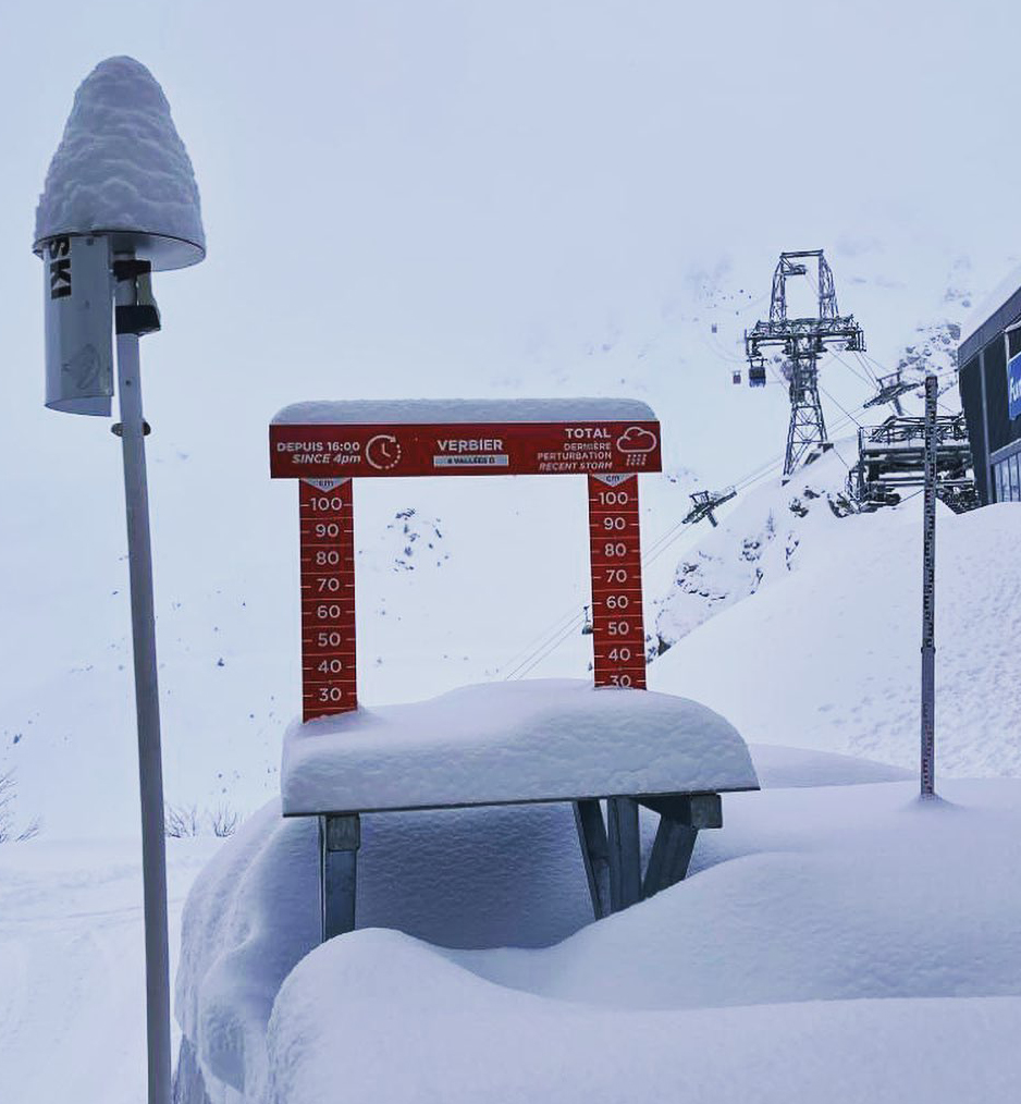
SWITZERLAND REPORT| There was a good deal of drama in Switzerland as ski areas were forced to close their slopes or were cut off from the outside world at the end of last week. Andermatt (130/450cm / 52/180”) was partially cut off after 60cm (two feet) of snow fell there taking its snow depth to the world’s deepest at present. It could still be accessed by rail through the tunnel into the resort. Zermatt (130/250cm / 52/100″) was completely cut off until Saturday lunchtime (rail and road) due to the avalanche danger. Glacier 3000 (100/300cm / 40/120″) could be accessed but the slopes were closed anyway due to the avalanche danger on the slopes, many other areas had only limited terrain open as the avalanche danger hit the highest level – 5 – at many resorts. The snow stopped at most areas over the weekend but returned, although with lighter falls, at the start of this week.
SWITZERLAND FORECAST| After the latest midweek snowfall, a dry few days are expected before more snowfall at the weekend. Temperatures generally cold but creeping up above freezing in the afternoon at lower resort bases.
FRANCE
FRANCE REPORT| French resorts saw huge snowfalls at the end of last week and lighter snowfalls since. Resorts still have their lifts closed by government order and that looks likely to remain the case thorough February but resorts have been able to stay open for tourism and have been doing all they can to encourage visitors, including grooming runs for ski tourers to skin up to then ski down if they wish to. With the avalanche danger hitting level 4 at many French resorts and level 5 at some that became a no-no due to the extreme danger and some snowshoers hiking in woodland were caught in an avalanche, thankfully all saved. As elsewhere in the Alps, warm temperatures at the end of last week also brought rain to unusually high altitudes on Friday and it was still rain rather than snow below 1500m altitude at times into the weekend. Several French resorts, including Val d’Isere, have passed the three-metre (10 feet) base level.
FRANCE FORECAST| It looks like there’ll still be more snow falling in the French Alps through this week, although with warmer temperatures at resort-level, continuing through the next few days. This may, unfortunately, fall as rain again at times on some resorts. Drier weather and periods of sunshine are possible from Thursday but staying warm on lower slopes and in resorts.
ITALY
ITALY REPORT| Italian ski areas remain closed but focussed on a February 15th reopening which currently most ski areas, including the largest, Dolomiti Superski, seem to believe will happen. Another key date is coming up this weekend with the opening of the Alpine Skiing World Championships in Cortina. Like most of the Alps the country’s ski areas have seen some good snowfalls in the past week, if not the extremes of ski areas a little further north. Further east in the Dolomites there’s been much less fresh snowfall but resorts say conditions are great and resorts are ready to safely open with pandemic procedures in place now with government approval. Temperatures have stayed lower, almost entirely below freezing day and night, than further north and the weather has been sunnier.
ITALY FORECAST| Some light snowfall is expected midweek but just a few centimetres then a return to mostly sunny, mostly cold weather. It’s forecast to be colder than further north and still close to freezing or below even down at resort level in most Italian areas.
GERMANY
GERMANY REPORT| Germany’s famous Garmisch Partenkirchen hosted Women’s World Cup speed racing last week and through the weekend but downhill races had to be cancelled due to the huge snowfalls and stormy weather the country’s alpine region experienced, with just GS races able to go ahead as conditions eased at the weekend. Races were cancelled again on Sunday due to fog. The men’s tour is due in town at the end of this week. The country’s current lockdown runs to the middle of the month and there’s speculation that even if resorts can open after then many now won’t bother; however, the Zugspitze, the country’s highest ski area, says it may stay open beyond its usual early May closing date, if allowed to open this spring, as it has a huge base from the winter storms, picking up another 38cm (15″) at the weekend.
GERMANY FORECAST| There’s more precipitation expected in Germany over the latter half of this week, but with temperatures rising some areas can expect rain, although more snow is likely for higher areas and higher slopes. Things should dry up from the weekend.
SCANDINAVIA
SCANDINAVIA REPORT| It has continued to be predominantly cold and sunny in Scandinavia since the weekend, but some small snowfalls have been reported at coastal areas like Voss (75/110cm / 30/44”) which reports 5cm (two inches) of fresh snow since Sunday. Most larger resorts like Hemsedal (135/135cm / 54/54″) are fully open although and the exception is the region’s biggest, Sweden’s Are (70/95cm / 28″38″), which does have all lifts running but only two-thirds of runs open.
SCANDINAVIA FORECAST| There’s very little change in the forecast with essentially wall-to-wall sunshine for most of the region for the coming week, just the first sign of a change to cloudier weather next Monday. Temperatures could be staying very cold, typically 15 to 30 degrees below freezing.
SCOTLAND
SCOTLAND REPORT| Scotland’s sensational ski season, without ski areas currently able to open due to pandemic lockdowns, continues with another week of cold snowy weather. Last Thursday/Friday saw around 36 hours of non-stop snowfall. It’s becoming one of the best seasons since the famed winter of 2010 with consistently cold weather for more than a month now meaning that if ski areas were open, most would have every run open. In the meantime, ski touring is popular but there have been issues with tourers being fined by police for breaking pandemic restrictions by travelling too far from home to ski (only local exercise is permitted in Scotland at present). There is also avalanche danger in the prone areas.
SCOTLAND FORECAST| There’s little change in the forecast for Scotland from the past six weeks with temperatures staying low and more periods of snowfall set to make conditions better still. Hopefully, this snow will all still be lying when ski areas can reopen.
SPAIN / ANDORRA
SPAIN / ANDORRA REPORT| The Pyrenees continue to be running a rather thwarted season with some ski areas open in Spain, all in Andorra and none, well none with ski-lifts operating, in France still. With travel limited in Andorra and Spain few people can actually get to the open slopes. As a result, only limited terrain is open in order to stem operating losses, even though centres could probably be fully open if they had more business to justify it. There’s been more snowfall over the weekend with ski areas in the Pyrenees posting 20-40cm (8-16″) more snow at the weekend. The region’s two largest areas, Grandvalira (50/100cm / 20/40”) in Andorra and Baqueira Beret (120/140cm / 48/54”) in Spain are both running about a quarter to a third of their slopes.
SPAIN / ANDORRA FORECAST| It remains a little warm with temperatures fluctuating between a few degrees above and a few below freezing on higher slopes but warmer down in resort. The next few days will be dry for most places with a mix of sunny and cloudy conditions. Snow clouds are expected to move in from the start of the weekend bringing another 10-30cm (4-12”) by Monday.
BULGARIA / ROMANIA REPORT
BULGARIA / ROMANIA REPORT| Conditions remain excellent in Bulgaria with low temperatures and a little more fresh snow. Bansko (40/170cm / 16/68”) has the deepest base and the most terrain open, including the long home run back down to the village which has a thicker snow cover on it than it has had for quite a few months. Pamporovo (60/140cm / 24/56”) has all of its lifts running and about three-quarters of its slopes open.
BULGARIA / ROMANIA FORECAST| It is warming up at last after the very cold final few weeks of January in Bulgaria’s mountains. Unfortunately, it looks like it will get rather warmer than they’d like by the end of the week with sunny weather heading into the weekend. It may get as high as 10 degrees above freezing at resort level, more like five above at the top of the slopes.
CZECH REPUBLIC / SLOVAKIA
CZECH REPUBLIC / SLOVAKIA REPORT| Ski areas in the Czech and Slovak republics have almost all seen big snowfalls over the past week, sharing in the snowy access seen in the Alps to the south over the latter half of last week. Alas, all ski areas in both countries remain closed by order of their governments due to the pandemic. When they might reopen remains uncertain. The latest known lockdown end date for Slovakia is this coming weekend but it may be extended. The Czech Republic has tightened its restrictions, including keeping ski areas closed, in the past few days and not given a proposed end date to the current position.
CZECH REPUBLIC / SLOVAKIA FORECAST| After the cold weather at the weekend and snowy weather last week it has stayed fairly dry in the Czech and Slovak mountains and that continues to be the case for the week ahead. Temperatures are unfortunately now creeping up after the cold January and many areas will see the thermometer registering digits above freezing even at the top of their slopes by Thursday or Friday, though fortunately, it should be only a few degrees above for most.
NORTH AMERICA
The big snow news in North America was the superstorm which hit California in the latter half of last week and brought heavy snowfall to a wider area too. The storm warning lasted from Wednesday to Friday with a forecast of up to 10 feet (3 metres) of snowfall for some areas and it certainly delivered at resorts like Mammoth. Ski centres had only just re-opened to ski tourism after an easing of lockdown requirements in California allowed hotels to reopen and the warnings from the resort switched from virus to the dangers of tree well and similar ‘snow suffocation’ dangers from the deep snow.
Elsewhere in North America, conditions continue to look good in most areas. The Rockies had some fresh powder but numbers remain below average for snowfall totals on the US side of the border. There’s been snow too in the northeast US and across Canada, just nothing like the amounts we’ve seen in California.
ROCKIES
ROCKIES REPORT| The Rockies received some moderate snowfalls over the weekend, allowing ski areas in the region to open more terrain, but the ongoing picture remains one of below-average snow totals here. Wolf Creek (97/104” / 244/259cm) in Colorado which is now operating in its fifth month of the season is perhaps the exception posting a deep base and all of its 130+ runs open. Park City (41/44” / 102/109cm) in Utah, the country’s biggest ski area, has all 40 of its lifts turning but it still some way off fully opening its full terrain, although about 75% of trails are now open.
ROCKIES FORECAST| Staying predominantly cold (5-15 degrees below freezing) with a mixture of alternating sunny and snowy days. Only light to moderate (2-6 inch / 5-15cm) snowfalls expected.
USA WEST
USA WEST REPORT| It was a spectacular end to last week in California with most ski areas reporting at least seven feet (two metres) of snow, with the most reported at one resort just off the 11 feet mark! The storm lasted three days, was accompanied by strong winds and a “don’t travel” storm warning just as travel was allowed again in the state as pandemic restrictions there were eased slightly. Storm totals in three days equated to more than some areas had received in the previous three months in some cases. Although avalanches were and remain a danger, the main warning from resorts was of the danger of snow suffocation, particularly of tree well deaths. Mammoth (94/127” / 241/318cm) reported one of the biggest accumulations. Further north, the snow has kept falling in Washington State and with another 26 inches since Sunday Mt Baker (159/178” / 396/445cm) has one of the deepest bases in the world at present.
USA WEST FORECAST| After a little light snowfall midweek the sun will be out into the weekend, with clouds returning at the start of next week. Temperatures hovering around freezing point, a little above or below at times.
USA MIDWEST REPORT
MIDWEST REPORT| It has been a cold and sunny few days in the midwest with temperatures varying between freezing and ten degrees below. That followed more changeable weather at the weekend which saw periods of strong wind, warmer temps, some rain but more snow too. Caberfae Peaks (55/55” / 137/137cm) in Michigan is posting the deepest base at present. Lutsen Mountains (24/41” / 60/102cm) in Minnesota reported the biggest snowfall at the weekend, four inches (10cm).
MIDWEST FORECAST| Quite a mixed bag with temperatures generally sub-zero and often 10 or 15 degrees below freezing, but occasionally popping into positive terrain. Sunny midweek but with light-to-moderate snowfall expected Friday then Sunday as temperatures dip lower still.
USA EAST
USA EAST REPORT| Conditions remain much improved in the northeast US with a mixture of blue ski days or light-to-moderate snowfall days whilst temperatures stay low. With all the snow that fell in January that has left some ideal conditions with fresh powder on a decent base for most resorts. Jiminy Peak (20/56” / 50/140cm) in Massachusetts is posting the deepest base in the region at present. Killington (36/36” / 91/91cm) has more than 150 trails open (almost full capacity), the largest area skiable in the region. Ski Sundown (35/35” / 89/89cm) has had the most fresh snowfall in the region, 16” (41cm) since Saturday. As this report is compiled, however, a major ‘noreaster’ with strong winds and heavy snow is hitting the region.
USA EAST FORECAST| Weather patterns are looking promising for the coming week with temperatures 5 to 15 degrees below freezing (so not as cold as it can be) and an ongoing mixture of sunny and snowy days. Friday and Sunday/Monday are currently looking the snowiest, the latter still some way off but currently looking to have the potential to be quite snowy.
CANADA
CANADA WEST
CANADA WEST REPORT| It has been a fairly snowy end of January and start of February in western Canada with resorts there posting up to 40cm (16 inches) of snowfall over 72 hours to start the week. Ski areas in Alberta and BC continue to be among a much more limited number than usual, operating all runs and all lifts when so many worldwide are either closed or only operating part of their ski areas to cut costs as visitor numbers are limited due to the pandemic. The continent’s largest area, Whistler Blackcomb (240/240cm / 96/96”), which reported 50cm (20 inches) of snowfall since the weekend, has every one of its 200+ trails open and most other resorts in the region have everything open too. Many continue to post that they have hit capacity (generally half normal capacity for pandemic operating safety) ahead of the ski day, especially at weekends.
CANADA WEST FORECAST| After the cold and snowy conditions of the past few days, it is quite a mixed weather bag for the coming week with some snowy, some sunny and some cloudy but dry days ahead with not too much of any of them. Temperatures should stay below freezing with snowfall most likely on Friday, before sunnier conditions through the weekend.
CANADA EAST
CANADA EAST REPORT| It has been very cold and mostly sunny in eastern Canada for much of the past week. Temperatures were generally down at ten below freezing point, sometimes touching 20 below or colder. Good weather for snow-making but with natural snow totals still way below average. The region’s largest area, Tremblant (30/60cm / 12/24”) has virtually all its runs open despite the thin base. There was a little snowfall on Tuesday for some areas. Ontario’s resorts remain closed by provincial order due to the pandemic and remain the only part of North America where that’s the case.
CANADA EAST FORECAST| Looking a little more changeable after the predominantly dry past week. Staying cold but not quite so cold with some light-to-moderate snowfall expected midweek, then more sunshine into the weekend, before the possibility of more light to moderate snowfall into the new week.
ASIA
JAPAN REPORT| Japan’s snowy December and January saw a slight slowing of pace in the final days of last month with many resorts seeing a dry end to the week before the snow returned to start this month. Niseko (190/350cm / 76/140″) saw about 30cm (a foot) of snowfall to start the week but strong winds and a small warming of temperatures bringing rain for a period blighted the good news. As we enter February most Japanese ski areas have already reported more snowfall than they received all of last winter 2019-20. Geto Kogen (280/410cm / 112/162”) continues to post some of the biggest snowfalls in the country this winter and now has one of the deepest bases in the world. It has had more than a metre (40”) more snow since the weekend.
JAPAN FORECAST| After the slight issue with the warmer temperatures it is getting cooler and snowier again for most Japanese resorts and the snowfall is expected to continue through the remainder of this week as normal snow delivery services resume.


