WORLD SNOW ROUNDUP #173
Issued: 06 January 2021
By Patrick “Snowhunter” Thorne
EUROPE INTRODUCTION
Cold is perhaps the keyword to describe conditions in Europe this past week and indeed forecast around most areas for the week ahead. It is still early January and therefore, the darkest part of winter. You’d like to think that’s how it would and should be, but the warm weather which has impacted much of the continent at times through the autumn and much of December makes you doubt it will get cold enough.
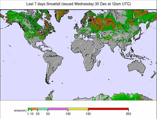
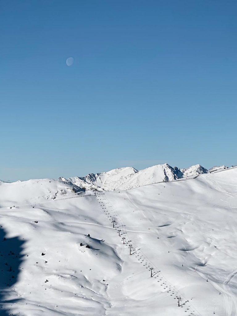
Most resorts in the Alps, Pyrenees, Scandinavia and Eastern Europe have seen some fresh snowfall, as much as 60cm (several feet) reported for some in Austria over the weekend. But most have had predominantly dry, sometimes sunny weather, which is again the picture for the week ahead too.
The season continues to be dominated by the virus, with the question of whether ski areas will open, will stay open and whether skiers will be able to reach the slopes from wherever they live due to local lockdowns and travel restrictions at their home addresses. The main things to report there are that although most Austrian areas have opened to locals, they’ve delayed opening to ‘ski tourism’ until later in the month. The date was initially the 18th, it is now the 24th. Similarly, France, Germany and Italy have delayed their planned re-opening from the previously announced 7th January to more likely 18th January or later. In addition, ski areas that were open over Christmas and the new year in Scotland and the Slovak Republic have now been told to close again. Ski areas in Andorra though have opened, initially to locals only, and ski areas in the Czech Republic may reopen from this weekend.
AUSTRIA
AUSTRIA REPORT| The weather has been fairly consistently cold and dry, with occasional sunshine over the past week across Austria. The only real break came as forecast at the end of last week and into the weekend with light to moderate snowfall for some areas. So Austrian ski areas have been posting pictures of superb conditions accompanied by apologies to those who find this infuriating when they can’t currently reach the slopes open to locals only. It has not been non-stop sunshine though with some areas in the southern province of Carinthia posting up to 80cm (nearly three feet) of snowfall over the weekend, though most got less than half that. A few resorts, notably Saalbach and Ischgl, are yet to open to even local skiers. Nassfeld (200/350cm / 80/140”) has the country’s deepest base and was one of those reporting a big weekend snowfall.
AUSTRIA FORECAST| The current cold and sunny weather is expected to be the norm over the coming week although periods of cloud and of light snowfall are expected, but never more than a few centimetres/an inch for most areas.
SWITZERLAND
SWITZERLAND REPORT| Switzerland continues to take a different path to the resorts of the major alpine nations with its ski resorts still open as they have been throughout the season to date. There are restrictions including public restaurants closed in most cantons although hotel restaurants are open in some cantons, including Valais, and mountain restaurant terraces have re-opened in Graubunden. For those who can get to Swiss slopes, conditions remain generally great, particularly at altitude. The 4 Valleys (40/120cm / 16/48”) continues to post the most terrain open at 280km (175 miles) with the recently re-opened freeride Gemsstock ski area at Andermatt (40/290cm / 16/116”) has the country’s deepest base. Saas-Fee (20/145cm / 8/58”) has had the most fresh snowfall however reporting 70c m (28”) of fresh over the weekend.
SWITZERLAND FORECAST| Very cold and very dry for much of Switzerland over the coming week with temperatures as low as 10 to 20 degrees below freezing which should keep things nice and crisp. Sunny weather is forecast most days though which should be good news for those lucky enough to be able to ski or board.
FRANCE
FRANCE REPORT| There was a little fresh snowfall to see in the new year in France with resorts reporting a few centimetres accumulating last Friday, and some heavy snowfall over the weekend for some. Otherwise, it has been a mostly dry, if cold, week. The country has been the centre of attention as the French government had still not published plans for ski areas opening (announced back in mid-December as being from Thursday 7th January) but with the date seeming increasingly unlikely as it drew near and other countries announced delays. There has now been a delay, for at least a week or two. In the meantime many French ski resorts are open, but the ski lifts remain closed, except for kids on nursery slope areas. Ski touring remains popular as conditions are very good, and one resort has even brought in horses to pull skiers up the slope, skijoring style.
FRANCE FORECAST| Predominantly cold weather in France too with temperatures generally 5 to 15 degrees below freezing. A mixture of sunny and cloudy spells with some snowfall possible in the northern Alps at the weekend, although currently it doesn’t seem like we should expect huge accumulations.
ITALY
ITALY REPORT| Great snow conditions in Italy for tourers who have been hiking up, as in other countries, to enjoy the weekend’s snowfalls, which brought 20 to 60cm (8-24 inches) of fresh snowfall to some areas (Trentino ski areas posted up to 40cm/16 inches, Lombardy up to 60cm/two feet). Italian ski areas remain closed to all, as in France, but the country does appear to have come up with a revised main-season-start date, now the 18th rather than the 7th of January.
ITALY FORECAST| As with the rest of the Alps we are looking at largely cold, dry conditions across Italy’s ski slopes over the week ahead. A mixture of sunny and cloudy spells with little snow expected, just the possibility of a few centimetres/inches at the weekend.
GERMANY
GERMANY REPORT| The main German ski news has unfortunately been dominated by the efforts of ski resorts, backed by police, to stop skiers and tobogganers heading to the slopes of Winterberg during the country’s current lockdown. It is not yet clear when German ski areas will be able to open as virus cases increase in the country and the lockdown there is extended. The most optimistic date at present is as early as January 11th, but that does seem, well, optimistic. Slope conditions at the closed resorts do appear to be generally good though with some fresh snow for many at the weekend and temperatures keeping low.
GERMANY FORECAST| Temperatures should stay low on German ski slopes through the coming week, allowing resorts to make snow in advance of opening if they wish. Some fresh natural snowfall is expected over the next 36 hours in many areas, but the latter half of the week and the weekend look dry and increasingly sunny.
SCANDINAVIA
SCANDINAVIA REPORT| It is looking good now for most Scandinavian ski areas with clear, cold weather and a decent snow depth at the majority of areas, allowing the majority of the region’s larger ski areas to now have most runs open and lifts turning. Of the big players, Norway’s Beitostølen (105/115cm / 42/46”) is one of the few in Scandinavia to have past the metre base-depth mark already. The region’s largest ski area, Are (45/63cm / 18/25”), in Sweden, has the most terrain open so far this winter with 80km of its potential 120km of runs open and all of its lifts operating.
SCANDINAVIA FORECAST| Sunny weather (during limited daylight hours still in the north, daylight only just returned up in Lapland) with temperatures between 10 and 20 degrees below freezing will be the norm for the rest of this week. Clouds will then roll in and temperatures ‘rise’ to 10 to five degrees below freezing, but there’s not much snow in the forecast.
SCOTLAND
SCOTLAND REPORT| An improving picture for snow cover in Scotland, but alas the three Scottish ski areas that remained open at the weekend were closed by new government restrictions from Tuesday, 5th January. Essentially, it has stayed consistently cold for several weeks now, with light snow flurries allowing snow-making systems to operate consistently too. As a result, each area had been gradually opening up more terrain and those lucky enough to live locally and therefore able to hit the slopes under Scotland’s Tier 4 near-lockdown restrictions had been enjoying great skiing. The three centres that were open are Glencoe (25/60cm / 10/24”), Glenshee (5/10cm / 2/4”) and The Lecht (10/20cm / 4/8”), but only people living in the regions where they’re located were allowed to ski at them. It is unclear now when the current full lockdown will be eased.
SCOTLAND FORECAST| There’s not a huge change in the Scottish snow forecast from the past few weeks with mostly low temperatures, rarely reaching freezing, and dry days. There’s very little snowfall forecast.
SPAIN / ANDORRA
SPAIN / ANDORRA REPORT| Things are improving fast in the Pyrenees at present for those lucky enough to be able to reach the region. There’s been more fresh snowfall giving great conditions and ski centres in Andorra opened at the weekend, initially for locals only, as are the already-open areas over the border in Spain. Ski areas in the French Pyrenees remain closed. Spain’s Baqueira Beret (70/90cm / 28/36”) has the biggest area open in the region so far with more than 80 trails open and 121km of runs. Andorra’s newly opened for the season GrandValira (30/45cm / 12/18”) has 76km of slopes open so far, about a third of its total.
SPAIN / ANDORRA FORECAST| Staying cold but sunny midweek in the Pyrenees with snowy weather, interspersed with sunny spells, expected from Thursday and continuing through the weekend.
BULGARIA / ROMANIA REPORT
BULGARIA / ROMANIA REPORT| A mix of reports from Europe’s southeastern ski nations. There have been some snowy days down in Bulgaria but further north in Croatia the Snow Queen World Cup competition battled very warm weather with machine-made snow on a green hillside, although that’s not really unusual for this marginal location for snow cover. The country’s Platak areas did open for the season though at the weekend with high demand reported. All four of Bulgaria’s main ski areas are now open, with Vitosha (10/20cm / 4/8”) the latest to do so, in the past week, but with thin cover and limited terrain open so far despite reporting 3cm (an inch) of fresh to start the week. Pamporovo (20/90cm / 8/36”) has the deepest snow.
BULGARIA / ROMANIA FORECAST| After a dry start to the week, it will be increasingly snowy in the latter half and into the weekend; however, temperatures will be fluctuating either side of freezing point and getting well above freezing down in the valleys which could be a problem at some areas for maintaining snow at lower elevations. 20-30cm (8-12 inches) more snowfall is possible by the weekend but so is a temperature of 10 degrees above freezing by then at the mountain base.
CZECH REPUBLIC / SLOVAKIA
CZECH REPUBLIC / SLOVAKIA REPORT| We have entered what we hope will be a brief period of no ski areas open in either the Czech or Slovak Republics. The Czech government closed centres down there shortly before Christmas and they’re due to reopen from next week, all being well; however, now Slovakia’s government, which had allowed ski areas to open over Christmas, has tightened restrictions and closed them again, for most of this month. Frustratingly, for ski areas, conditions are the best they’ve been this season so far with fresh snowfall to start this week and temperatures staying low.
CZECH REPUBLIC / SLOVAKIA FORECAST| With the fresh snowfall at the start of this week and the current low temperatures just reaching freezing point in the valleys by mid-afternoon, it does look good for skiing in the Czech Republic if resorts are able to re-open as they hope from Sunday. It’s looking mostly dry over the week ahead although there should be more light to moderate snow showers as well as sunny spells in between.
NORTH AMERICA
It’s an ever-improving picture for ski areas across North America, at least in terms of snow cover. No really huge dumps to report, as has been the case for much of the past few months, the biggest falls have been reported in the Pacific Northwest of the continent; however, most areas have seen generally cold to very cold temperatures and at least some fresh snowfall. As an added bonus there have been few bad weather incidents to report this past week. There were ice issues in parts of California and some rain at lower elevations in the northwest but the northeast of the continent, which has suffered periods of warm weather and rain right up to the end of the year, this past week has seen more consistently cold weather and some fresh snowfall.
The virus continues to dominate operations and many resorts have been reporting their limited allocation of lift tickets has been selling out in advance (often days and sometimes weeks in advance) over the New Year period. Most resorts continue to operate however, only those in the province of Ontario in eastern Canada remain closed by their region’s government.
ROCKIES
ROCKIES REPORT| Some more fresh snowfall in the Rockies but not yet many of the big dumps the region expects this winter so far. In Utah, there are reports (following similar in Colorado) of snow totals being well below average still so far this winter. The biggest snowfalls in recent days have been up in the north of the country with resorts in Idaho, Montana and Wyoming posting 12 inch (30cm) snowfalls from the past 72 hour period, among them Jackson Hole (19/63” / 48/157cm) and Tamarack. Wolf Creek Ski Area (70/81″ / 175/203cm) is the first to report an 80 inch/two-metre snow depth in the Rockies this season.
ROCKIES FORECAST| It’s generally cold (5 to 15 degrees below freezing) and mostly sunny along the length of the Rocky Mountains region as we move into the latter half of this week. The only snow clouds in sight are in the north of the country for some resorts in Idaho, Montana and northern Utah. There is a chance of some light snowfall at the weekend but for most staying dry and often sunny.
USA WEST
USA WEST REPORT| Ski areas in the western US continue to post the most snowfall and deepest bases on the continent. In the latter category, Bluewood (60/60″ / 150/150cm) has posted the most snow in the US over the first few days of this week with 20 inches (50cm) more snowfall. Mt Baker (130/145″ / 325/363cm), and if you include weekend snowfall, has had 45 inches (over a metre / almost four feet) more snowfall this week already. Further south in California the snowfall increase has been in single digits but resorts have the most terrain open. Squaw Valley Alpine Meadows (38/58″ / 95/145cm) has one of the largest ski areas open in the world so far with some 4,000 acres reported skiable.
USA WEST FORECAST| After a snowy start to the week, it will be drier over the next few days before snowfall returns on Friday and continues through the weekend for many areas. Temperatures generally staying well below freezing with mostly cloudy conditions although the occasionally sunny period breaking through.
USA MIDWEST REPORT
MIDWEST REPORT| The midwest has seen it all over the past week with periods of freezing rain and snowfall mixed with sunny and dry cloudy spells when snow-making systems could fire up. Temperatures have stayed fairly low though and most of the region’s ski areas are now open. Welch Village (20/49″ / 51/127cm), in Minnesota, is posting the deepest base of open ski areas in the area; however, ski areas in Michigan have posted the most snowfall in the past few days with Mount Brighton (28/28″ / 71/71cm) posting five inches (11cm) of natural snowfall in the past few days.
MIDWEST FORECAST| Remaining predominantly dry and predominantly cloudy although with a few sunny days likely at the weekend. Overnight temperatures will be well below freezing, occasionally scratching positive temperatures at the height of the day.
USA EAST
USA EAST REPORT| After the warm wet spell damaged slopes over Christmas weekend, thing have been much more consistently cold and indeed snowy in the northeast over New Years and so the picture is much improved. Some fresh snow for most areas but the past few days have seen New York State and Pennsylvania do especially well with Belleayre (12/36” / 30/91cm) in the former and Elk Mountain (24/48” / 61/120cm) both reporting another six-inches (15cm) of snowfall since Sunday. Even where the snow hasn’t been falling most areas have had good snow-making conditions.
USA EAST FORECAST| A largely dry week ahead, but very cold (10-20 below freezing), allowing the region’s famous snow-making arsenal to operate at full blast. Cloudy weather for most until the weekend when sunshine should return.
CANADA
CANADA WEST
CANADA WEST REPORT| Another very snowy week in western Canada with Fernie (90/180cm / 36/72”) reporting up to 70cm (28 inches) of fresh snowfall over the weekend and Panorama (60/108cm / 24/43”) reporting 30cm (a foot) more snow on Sunday alone. Both areas and others in the region have had to close some terrain at times whilst it was made avalanche safe and warn that the general avalanche danger in the region is extremely high. Whistler Blackcomb (0/238cm / 095”) reports 180km of runs open, about 90% of its terrain and one of the largest areas open in North America and the world at present. It posted another 64cm (26”) of snowfall on the first few days of this week.
CANADA WEST FORECAST| After the snowy start to this week more Sunshine is expected for the week ahead, although temperatures should remain cold, with highs around freezing point in the daytime, lows around 15 below at altitude at night. More snow is expected later in the week on the Alberta/BC border but remaining drier further west.
CANADA EAST
CANADA EAST REPORT| It’s an improving picture in eastern Canada following the warm and wet spells that marred the autumn and much of December in the region. That’s not a big help for Ontario, which at time of writing, remains the only region in North America where the government has closed the lifts, leading to big online protests. In Quebec though several larger resorts are now reporting more than a metre (40 inches) of snow lying and fresh cover on top. Mont Sainte Anne (120/129cm / 48/52″) for example with 12cm (five inches) of fresh snowfall over the past few days.
CANADA EAST FORECAST| It will be staying very cold (typically 5 to 20 degrees below freezing day and night) and mostly sunny in the daytime and generally dry over the coming week in Eastern Canada, good for snow-making if not snowfall.
ASIA
JAPAN REPORT| After last week’s dip in snowfall following the huge pre-Christmas accumulations, things have turned snowier again in Japan with as much as 220cm (over seven) feet of snowfall reported by reporters for SnowJapan.com in just 72 hours over New Year at Geto Kogen (290/410cm / 116/164″), which is now also posting the deepest base in the world. Elsewhere in the country, there have been big accumulations too for resorts like Nozawa Onsen (150/275cm / 60/110cm) which reported 75cm (30 inches) in the same 72 hour period whilst Niseko (150/250cm / 60/100”) reported 1.2 metres (four feet) more snowfall in the past week.
JAPAN FORECAST| A few sunny days are expected midweek, or at least days when the sun manages to break through for a time but a third huge snowstorm is on the way.


