WORLD SNOW ROUNDUP #129
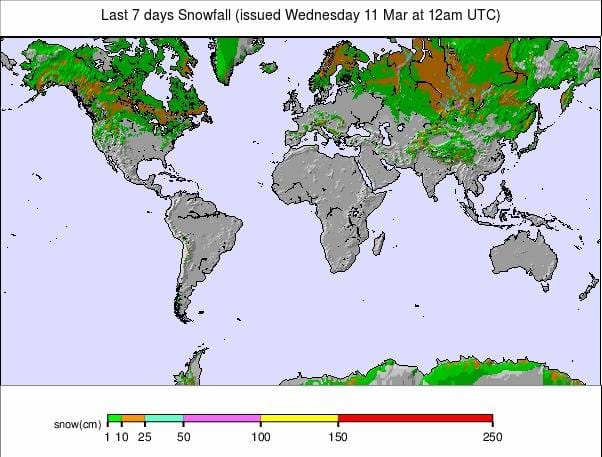
Issued: 11 March 2020
By Patrick “Snowhunter” Thorne
INTRODUCTION NORTH AMERICA
The past week has been much calmer in North America than recent periods with much less snowfall reported anywhere than has been the case for most of our reports this year.
What fresh snow has fallen has largely been in the west of the continent with some good snowfalls of one to two feet (30-60cm) reported in the Rockies, California and further north up in Alaska, Alberta and BC.
It’s been less good news for eastern parts where, after some good snowfalls recently, temperatures have warmed up considerably with periods of rainfall too. That should improve over the next few days though.
USA
ROCKIES
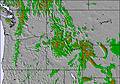
ROCKIES REPORT It has been predominantly warm in the Rockies over the past week with the temperature climbing above freezing. There has been snow falling but long-time locals have been complaining that snow in warmer temperatures (by Rockies standards) is not as light and fluffy as they’re used to. But then we are getting towards the mid-point of March.
ROCKIES FORECAST It looks like conditions should be fairly calm, dry and sometimes a little warm over the next few days before things get colder and snowier in the Rockies region at the weekend. Heavy snow is forecast, increasing the further north you go. Some ski areas in Utah, for example, are expected to see up to 60cm (2 feet) of snowfall over Saturday/Sunday if the conditions play out as forecast.
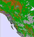
WEST
USA WEST REPORT The snowfall has slowed down over the past week but it has kept snowing and two of the three ski areas in the world, which currently have snow lying more than 17 feet deep (5.1 metres), are in Washington state. It’s been snowy too in Alaska and there’s been more fresh snow for California so, all-in-all, a good picture as we head into spring. Alpental (104/215” / 259/538cm) still has the deepest snow in the world at present.
USA WEST FORECAST It looks like the seemingly unending heavy snowfall and precipitation in the northwest may finally be ending for a few days at least with less snow in the forecast. Things do look to be turning snowier from the weekend though and, unusually for this season, there may be more snow in California in the south of the region over the weekend than further north.
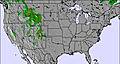
MIDWEST
MIDWEST REPORT It has been dry for most parts of the Midwest in recent days with temperatures hovering around freezing. There’s something of an end-of-the-season feel at some of the smaller centres and, indeed, some have already closed. Most of those still open are running about 60-80% of lifts and have a similar proportion of terrain open. Big Powderhorn in Michigan (30/61” / 75/152cm) has one of the best snow depths in the region.
MIDWEST FORECAST It’s looking like another week with not much snowfall expected in the Midwest. Unfortunately, what precipitation there has been in March has often fallen as rain or sleet as much as snow and it looks like a similar scenario for the week ahead.
EAST
USA EAST REPORT Sadly, conditions have deteriorated a good deal in the Eastern US with unseasonably warm temperatures and rain over the past few days impacting snow conditions. That said, thanks to the heavy snowfall at the end of February and in the first few days of March, most areas have good cover and have everything open. The forecast is for colder weather which should improve things. Sugarbush in Vermont (36/62” / 91/155cm) has the deepest base in the region and everything open.
USA EAST FORECAST The current warm spell is easing off and we should hopefully be back to double digits below freezing by the weekend for more northerly resorts. The amount of snow expected at the weekend should send snow cover back in the right direction in time for the final weeks of the season.
CANADA
WEST
CANADA WEST REPORT After a rather warm period going into last weekend (and since), Western Canada got a short-sharp return of mid-winter on Saturday/Sunday as temperatures dropped to double digits below freezing for many mountain areas. Mt Washington (203/285cm / 81/114”) reported one of the biggest snowfalls in the country over the last 72 hours with 40cm (16 inches) but there was slightly more on the eastern side of the region in the Banff area with Lake Louise (188/210cm / 75/164”) posting 42cm (17 inches) and similar falls at nearby Norquay and Sunshine. So in short, snowy again across Western Canada.
CANADA WEST FORECAST Staying cold (often double digits below freezing) with a mixed picture of sunny days, cloud and snow in the forecast for Western Canada. So far the snowfall is looking fairly light over Thursday/Friday compared to last weekend with 10-20cm (4-8 inches) more forecast in most areas.
EAST
CANADA EAST REPORT Unfortunately, particularly after the great snowfall of the previous fortnight, in recent days it has been back to warm and wet in Quebec and Ontario, returning to the issue that undermined the first few months of this season. Thanks to all the snowfall of late February and early March, this time ski areas do, on the whole, have reasonable bases. Therefore, are still generally 75-100% open; obviously skiing in the rain isn’t fun or good for the snow surface. It is, however, due to get colder. Owl’s Head (140/140cm / 56/56”), down in the Eastern townships, has the deepest base in the region.
CANADA EAST FORECAST A real mixed bag in the forecast for the next few days in Eastern Canada with yoyoing temperatures between double-digits below freezing and highs well above freezing bringing rain, sleet, windy days, sunny days and snow.
INTRODUCTION EUROPE
The heavy snowfall at the end of February and start of March in the Alps has eased off a good deal in the past few days although some areas have had up to 30cm (a foot) more snowfall in the first half of this week; however, for most, it has turned rather warm, dry and sunny for the next few days at least. All that snow is still lying there though so most ski areas across the region are fully open with good conditions. Only in Italy, which ironically saw some of its best snowfalls of the season during the past fortnight in some regions including the Dolomites, are ski areas all completely closed in the battle against the coronavirus.
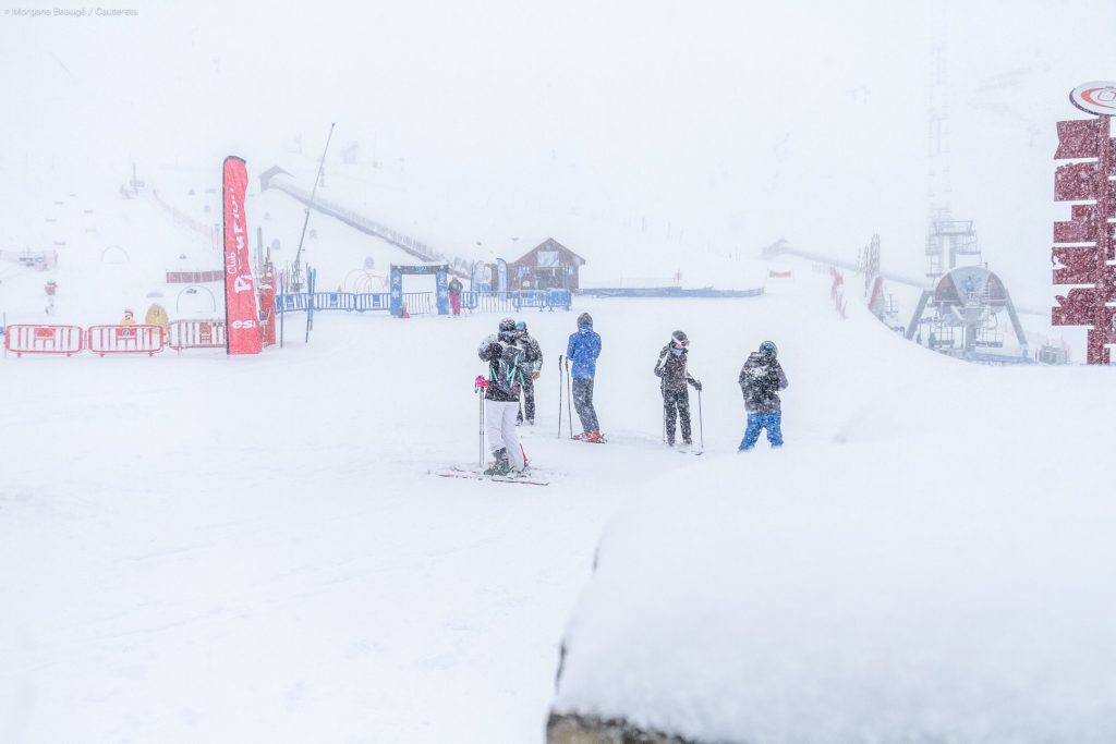
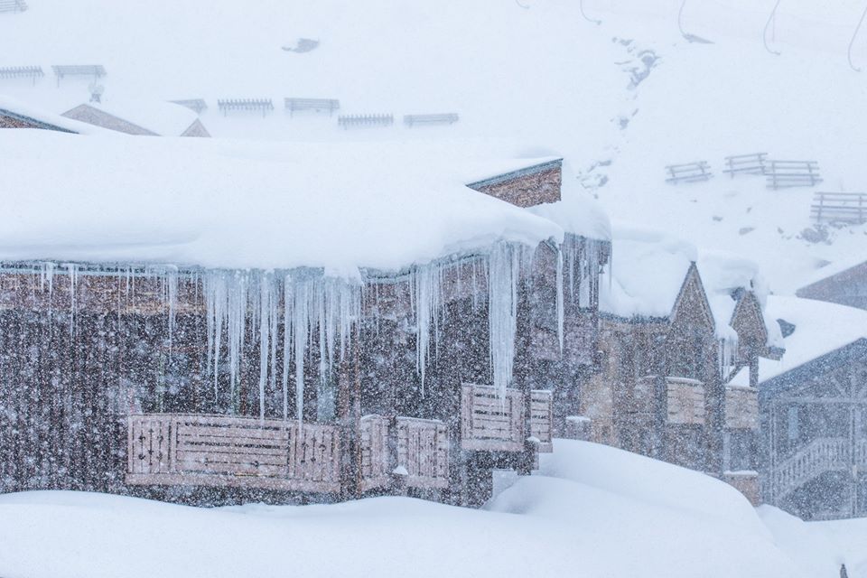
The biggest snowfalls of the past week have actually been recorded in the Pyrenees, where some centres saw up to a metre of snowfall into the weekend, dramatically improving conditions there.
Elsewhere, there have been some heavy snowfalls. Eastern Europe is seeing its best snowfall of the season, the latter weeks and months on 2019-20 being the best. Up in the north, a ski area in Norway has become the first in Europe to reach a five-metre base depth this season and Scotland continues to report one of the best periods of snow cover during the past few years.
AUSTRIA

AUSTRIA REPORT Austria’s heavy snowfall continued through last week with more sizable accumulations and at one point St Anton (120/450cm / 48/180″) had Europe’s deepest snow depth on its higher slopes. Since the weekend the snowfall has eased off and for most areas it has been just small to moderate 5-10cm (2-4 inch) accumulations over the past 72 hours. The Dachstein Glacier (405/405cm / 162/162”) has become the second ski area in the country to reach a 4-metre base. The general picture is good for most of the country’s higher destination resorts with all slopes open and good snow depths. The deepest snow is typically in Tirol, Salzburgerland and Carinthia provinces.
AUSTRIA FORECAST As with most of the rest of Western Europe the weather in Austria has warmed up a good deal in the past 24 hours. The rest of this week is looking a little too warm for the snow although it should be nice and sunny. Currently, it looks like temperatures should drop back below freezing later in the week with light to moderate snowfall forecast for Friday into Saturday with more sunny weather beyond.
SWITZERLAND

SWITZERLAND REPORT There’s been a mixture of sunshine and snowfall in Switzerland over the last seven days with temperatures climbing above, then dropping back below, freezing level. The country has been getting some of the biggest dumps on the planet when it has snowed. Four of the five ski areas in Europe that posted over a metre of snowfall during the past week are Swiss, with Gstaad’s Glacier 3000 glacier ski area (60/299cm / 24/120”) posting 90cm (3 feet) of fresh snow, the largest for one of the country’s bigger resorts. Resorts in the 4 Valleys posted up to 80cm (32 inches) of snowfall. So there has been great conditions for skiing this past week with the avalanche danger not climbing too high in some areas.
SWITZERLAND FORECAST Much more settled weather is forecast for the coming week in Switzerland with more sunshine than in recent weeks. Temperatures should hover around freezing, sometimes getting a few degrees above but often staying a little below. There will be periods of light to moderate snowfall, heavier in the east and probably at the end of the week; however, for most areas, it doesn’t look like it will add up to more than 10-20cm (4-8 inches).
FRANCE
FRANCE REPORT The heavy snowfall of last week has eased off in the French Alps and the past few days have been largely dry with just occasional light snowfall. It’s a different story down in the French Pyrenees though where the end of last week and the weekend saw huge accumulations. La Plagne (210/475cm / 44/190”), which has the deepest base in the Alps, again reported one of the biggest accumulations in the country for the last seven days as a whole (well, the Alps at least) with another 445cm (18 inches) of snowfall. Conditions remain good across most of France with temperatures around freezing and most areas fully open.
FRANCE FORECAST In common with much of the Alps the next few days in France are looking dry, sunny and rather warm with temperatures climbing to five or even ten degrees above freezing in the valleys for a time. Temperatures should fall away again from Friday, hopefully before much damage is done to the snowpack. There may be some light to moderate snowfalls to start the weekend as temperatures drop back below freezing. More clear weather is expected into next week with little fresh snow, but it could be colder again.
ITALY

ITALY REPORT Should we be writing an Italian ski resort when all lifts and ski areas in Italy are now closed in the effort to stop the spread of the coronavirus? This is new territory for us. Of course, skiers and boarders or not, the snow is still there and we’re not clear what the position is if people want to hike up. We don’t think skiing and boarding itself is actually banned. So without specifying resorts and snow depths, we can report conditions are generally good-to-excellent across Italy. Regions like Piedmont and the Dolomites have had more fresh snowfall in the past week or so than they had all year to date and some areas in the Alps had reported over a metre (40 inches) more snowfall in the past seven days.
ITALY FORECAST The week ahead looks sunnier in much of Italy than it has for the previous month or so. The next few days look rather warm, then some light snowfall at the end of the week is possible as temperatures dip back below freezing.
SCANDINAVIA

SCANDINAVIA REPORT Another 50cm (20 inches) of snowfall in the past week has left Roldal (300/510cm / 120/204”) in Western Norway claiming to have the deepest snow in Europe and to be the first in the continent to post a 5m (17 foot) plus base. Voss (170/370cm / 68/148”) has had more snowfall this week though, posting 70m, over two feet more snow. It has been another generally cold and sometimes snowy week across most of Scandinavia though and centres there are reporting excellent conditions, if not quite such deep snow lying as in Western Norway.
SCANDINAVIA FORECAST It’s looking like a snowy remainder off the week in much of Norway with temperatures expected to stay a little below freezing. The weekend should see brighter and drier conditions for a time, although still below freezing in most ski areas, before the return of more snow.
GERMANY

GERMANY REPORT Germany has experienced another generally snowy week with March delivering some of the best snow conditions of the season. Most of the country’s destination resorts are fully open and reporting powder like snow conditions after successive days of snowfall. The Garmisch and Zugspitze areas have the deepest snow, Garmisch Classic (30/190cm / 12/76”) with all lifts operating ad all lifts running. The low depth stats down at the base remains common at most German areas.
GERMANY FORECAST Alas, after the past week or so of snowy weather in Germany a temperature spike is forecast for the latter half of this week with temperatures heading well up above freezing, reaching double digits in the valleys but also getting warm on higher slopes too. There’s not much precipitation forecast but what does come looks likely to be rain. Cooler weather with the potential for more snow at the weekend.
BULGARIA and ROMANIA
BULGARIA / ROMANIA REPORT Bulgaria’s snowy start to spring has continued with some more heavy snowfalls in the past week. Borovets (50/250cm / 20/100”) has the deepest snow in the region and, in common with all of the country’s areas, is now fully open. Bansko (50/100cm / 20/40”) has the most terrain open and the long run down to resort from the ski slopes is currently reported to be in the best shape it has been all season.
BULGARIA / ROMANIA FORECAST The snow showers should ease off through the middle of this week with just light snowfall now and then clear, sunny skies to end the week. There is fresh snow to enjoy, although temperatures will be rather warm again, five or six degrees above freezing. But another band of snow bearing clouds should move in at the weekend with temperatures dropping away creating the potential for heavy snowfall.
CZECH REPUBLIC and SLOVAKIA
CZECH REPUBLIC / SLOVAKIA REPORT A snowy end to last week. Drier conditions since the weekend in the Czech and Slovak republics with just a little light snowfall reported since Sunday. Thanks to the heavy snowfall at the start of this month though conditions are about the best they’ve been all season in many parts of the region with decent depths and everything open. Slovakia’s Tatranská Lomnica (30/130cm / 12/52”) has the deepest snow reported and all lifts turning and all runs open.
CZECH REPUBLIC / SLOVAKIA FORECAST A mostly dry week ahead with temperatures climbing well up above freezing at most ski areas in the region. Therefore, some thawing seems likely. The forecasts are promising for the area’s bigger, higher ski areas like Jasna which may even see a few centimetres of snowfall at times over the coming week.
SPAIN and ANDORRA
SPAIN / ANDORRA REPORT The Pyrenees, and especially the French Pyrenees, have had a very snowy week and actually reported the biggest snowfalls in the world over the weekend Although it was a close run thing with some resorts in the Alps and in North America’s Pacific Northwest region. Cauterets (75/145cm / 30/58”) reports 75cm (30 inches) of snowfall over the weekend and almost double that in the last week, a really huge transformation after the mostly snowless first few months of 2020. Good snowfalls across the Pyrenees too, if not quite so much in Andorra and Spain. Baqueira Beret (80/190cm / 32/76”), on the Spanish side, said it had had up to 70cm (28 inches) of fresh snow but warned the avalanche danger off-piste is very high at level 4 on the scale to 5.
SPAIN / ANDORRA FORECAST After the past cold and snowy week it’s looking much drier and sunnier over the next seven days with little if any snow in the forecast. In fact, temperatures look like they could get warmer than is good for snow conditions quite quickly, moving 5-10 degrees above freezing in the sunshine over the next few days. Turing cooler, but still above freezing, into the weekend.
SCOTLAND

SCOTLAND REPORT Conditions remain good but classically Scottish in the Highlands with good coverage across all five Highland centres; however, periods of strong winds have closed lifts and rain has turned to a mixture of sleet and snow. More than 80 runs are open across the five centres with Glencoe (40/200cm / 16/80”) continuing to post the deepest base and almost everything open. Cover it a little marginal at The Lecht (20/60cm / 8/24”) in the east where some runs have closed due to thawing but there’s still a lot open.
SCOTLAND FORECAST Another week maintaining the patterns of the past few months looks to be in order with light to moderate snowfall expected for the rest of this week in the east. Heavier snowfall could bring 60-90cm (2-3 feet) more snow over the next seven days for ski areas like Glencoe and Nevis Range.
JAPAN
JAPAN REPORT Another week of light to moderate snowfall and a general spring-like feel on the slopes in Japan with about 20cm (eight inches) of snow reported in the past seven days at Niseko (90/320cm / 36/128”) and temperatures fluctuating between ‘quite warm’ in the valley on the sunniest days to double-digits below freezing up on the slopes and snowing on colder days. Occasional periods of rain when the warmer air meets precipitation. As has been the case for much of this season conditions are partly down to perception. On the one hand, depths are quite good up on Hokkaido, certainly deep enough to see out the season and everything is open. Against that the powder days have been less common and less deep than usual which has long time powder perfectionist fans of Japanese skiing and boarding decrying this as the worst ever season. And now we have the coronavirus and a state of emergency on Hokkaido too, although ski areas are still operating.
JAPAN FORECAST Not much change in the forecast for the coming week with temperatures yoyoing between well above freezing and well below. More light to moderate snowfall (possibly occasionally rain) and some periods that are also quite windy in the week ahead according to the forecast.


