EUROPE WEEKLY ROUNDUP #230
Europe Intro
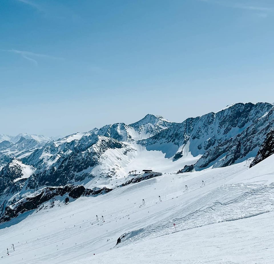
It was a fairly quiet week for snowfall in the Alps after the 20-50cm (8-20″) accumulations last week, until falls of up to 30cm (12”), but 10-20cm (4-8”) was reported across the region on Tuesday morning, earlier than expected. There was some snow showers before this and base depths on upper slopes are up marginally compared to a week ago, but most have been light and there has been much more sunshine. Southerly European mountains have been back to seeing double figure temperatures at 1,000m and even at 1,500m at times; these abnormally warm temperatures in January and February have resulted in a variations of the phrase “Spring is here early” being banded about as we enter the final week of meteorological winter time. Winter still exists in Scandinavia, however, where temperatures have remained more reliably sub-zero and the snow more consistently powdery without the freeze/thaw further south. But it’s important to note that most slopes remain open and most skiers are happy on the groomed runs, hardpacked with a little fresh on top.
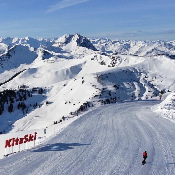
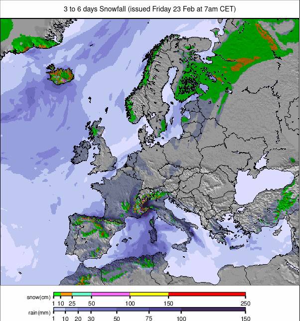
Image: European snowfall summary overview for the next 3-6 days.
Austria Report
It has been a better week than recent ones in Austria, with regular snow showers between sunny periods of up to 30cm (12”), refreshing the slope cover nicely. Temperatures have been lower but still in the +5C to +10C range and, despite the fresh snowfall, this is finally beginning to have an impact on open terrain – albeit a small one so far on the bigger areas. The Saalbach Hinterglemm Leogang Fieberbrunn Skicircus (50/120cm / 12/48″) has dropped to 82% open with 50km (31 miles) of mostly lower slopes closed, although that still leaves 220km (137 miles) open. The biggest open area, St Anton and Lech’s Arlberg (65/360cm / 26/144″), has dropped a little to 90% of its 300km (187 miles) of runs, but that’s still plenty to see it through the remaining 10 weeks or so of the season.
Austria Forecast
Colder, snowier weather is forecast for the coming week, with the freezing point dropping down the valley where daytime highs will be closer to 5C than 15C. Accumulations of 20-40cm (8-16″) are possible by the weekend so one of the most promising forecasts for a while.
Switzerland Report
You know things are looking too warm when the FIS Women’s World Cup Downhill races at Crans Montana (1090/160cm / 40/64”) are on a shortened course at 1500m due to strong wind. The organisers of the famous White Turf races at St Moritz (10/90cm / 4/36”) also couldn’t guarantee the safety of horses and riders on what should be a frozen lake at 1850m after a drone survey spotted cracks and wet patches. These are all signs of the warm temperatures that have plagued the Alps, including Switzerland, for much of 2024 so far. There have been more snow showers though, with Engelberg (100.300cm / 40/120” reaching a 3m/10 ft base up top for the first time this season after 23cm (9”) there on Tuesday. Most Swiss ski areas remain fully open, but warm valley temperatures creating wet snow down low continues to be an issue. The 4 Valleys around Verbier (22/258cm / 9/103”) remain more than 95% open, however, offering 390km (146 miles) of piste with the most still in the country. Upper base depths are more than 10 times lower slope depths now though.
Switzerland Forecast
The latter half of this week is looking promising for some decent snowfalls in the region of 20-40cm (8-16”) on higher slopes by the weekend. Temperatures also dropping down to double-digits below freezing overnight above 2,000m and closer to freezing in valleys even in the daytime. So more like February norms.
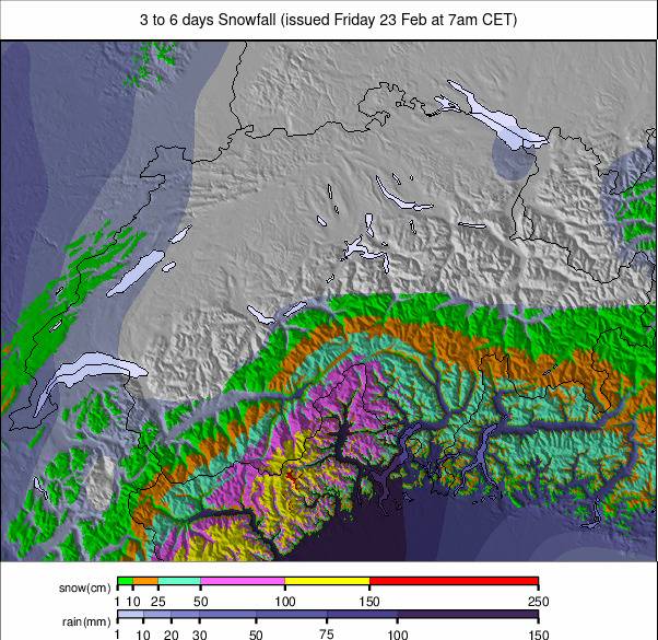
Image: Switzerland snowfall forecast for the next 3-6 days.
France Report
Mostly sunny days again across the French Alps but with occasional light snowfalls up high, but the bigger snowfalls expected over the past few weeks have not really materialised so far. That said, 5-10cm (2-4”) falls were reported on Tuesday morning over the previous night, a surprise for many. It has been cooler the past week than for much of the first half of February in the northern Alps with the freezing point generally moving between 1000 and 2500m altitude, the warmest temperatures in the high single figures in valleys. However, we’ve seen +15C in Valleys in the southern Alps, which conversely saw the biggest snowfalls 10 days ago. There’s not been a great change in snow depths, with France just clinging on to the deepest-bases-in-the-world position as the only country where the 4-metre mark has been reached on higher slopes, almost all of the country’s large ski regions remain 90% or more open too. They include the 3 Valleys (140/200 cm / 56/80”) with 555km / 347 miles) of runs open – 92% of the maximum terrain and the most in the world.
France Forecast
We again have forecasts of 20-50cm (8-20”) of snowfall in the final few days of this week, with temperatures dropping too. Whilst fresh snowfall will be welcomer, snow experts like Henry’s Avalanche Talk are warning that the snowfall, if it arrives as forecast, could cause great danger on some slopes due to the mix of current conditions.
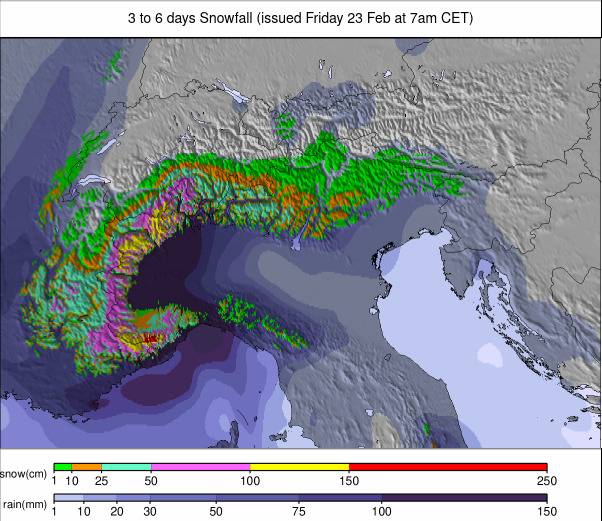
Image: European Alps snowfall forecast for the next 3-6 days.
Italy Report
There have been some light snowfalls on high slopes across Italian mountains over the past week but the main weather conditions have once again been warm, dry and sunny with the freezing point up at about 2,000m and valley temperatures reaching +10 to +15C. Most Italian slopes remain open, at least in the Dolomites and Alps, not so much in the Apennines to the south which have had and continue to have a very challenging winter. La Thuile (97/325cm / 39/130”) is posting Italy’s deepest base and Val Gardena is the most open terrain entirely within Italy, with 180km (113 miles) of runs open in its Dolomites Valley (The Via Lattea/Milky way and Cervinia/Zermatt both have more – nearly 300km (187 miles) each, but not all in Italy, if that matters.
Italy Forecast
There is significant snowfall expected later this week with temperatures due to drop. A front moving through on Thursday/Friday could bring 20/40cm (8-16″) accumulations on upper mountains if the snow arrives as the modelling predicts. Much colder weather with valley temperatures dipping back below freezing overnight and the daytime freezing point at about 1500m.
Germany Report
There has been some snowfall throughout the weekend on higher German ski slopes with 5-20cm (2-8”) accumulation totals reported. About three-quarters of the country’s smaller ones are mostly closed as they are at levels too low for reliable snow cover this winter. By contrast, the 50 or so commercial centres with higher terrain are overall close to fully open but suffering thin, wet snow cover on lower runs. It has remained warm below 1500m, reaching 10C+ in the afternoon. Lastly, it’s no surprise that as (almost) always the highest slopes at Zugspitze (120/246cm / 48/99”) have the deepest snow, and 100% open Balderschwang (30/50cm / 12/20) has the most open terrain in the country with 41km (26 miles) despite the thin cover.
Germany Forecast
After another few days of warm, sunny weather, snowfall is expected to lower elevations from Thursday/Friday with temperatures dropping back towards freezing as well. It’s not going to be enough to really transform things for those without enough snow cover already.
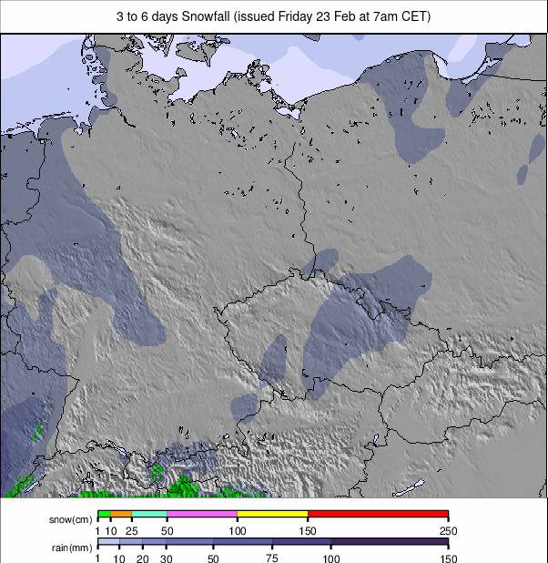
Image: Germany snowfall forecast for the next 3-6 days.
Scandinavia Report
Scandinavian centres continue to post the lowest temperatures in European skiing and more fresh snowfall. Downhill racers in the Men’s FIS World Cup Tour on its stops at Norway’s Kvitfjell (20/80cm / 8/32”) at the weekend had lows of -10 to -20C, thus keeping the course in great shape. However, it’s further west around Voss (175/190cm / 70/76”) that the region’s deepest snow is to be found, while the region’s largest ski area- Sweden’s Åre (50/90cm / 20/36”)- has 90% of its slopes open. After the Fonna Glacier reported the snow lying 10m (400”) deep ahead of its spring/summer 2024 season start in May, Europe’s most northerly major resort, Riksgränsen, is due to open for its 2024 season this coming weekend.
Scandinavia Forecast
There are some big snowfalls, potentially the biggest in Europe this week, forecast for the last three or four days of this week. Temperatures will be warmer than they have been, up to -5 to +3C, but up to 60cm (two feet) of snowfall is expected within 72 hours.
Scotland Report
Mild temperatures have been testing the snow reserves of Scottish ski areas, leaving most centres with little more than their base area nursery slopes still operational until the next temperature drop and fresh snowfall arrives, hopefully later this week. Glencoe and Nevis Range have been forced to close their ski slopes again and The Lecht is back to beginner only runs. Cairngorm and Glenshee were battling to have a few more runs open at time of writing but it has been touch and go.
Scotland Forecast
Temperatures are due to drop in the latter half of this week with fresh snowfall forecast. Its unclear as yet whether this will be enough to enable runs to re-open.
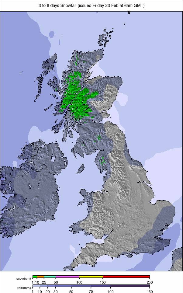
Image: UK and Northern Ireland snowfall forecast for the next 3 days.
Spain/ Andorra Report
After the fairly relentlessly dry, warm and sunny first half of the season we’ve entered a period of more changeable weather in the Pyrenees. Fronts are bringing in some snowfall every few days, the amount falling variable (typically 5-15cm/2-6″) and mostly benefiting higher slopes as afternoon temperatures in valleys continue to reach +5 to +10C, however, so any snow making it down that low doesn’t last long. There have been sunny days in between the snowy ones. The snowfall isn’t really impacting the terrain open, which averages 55-65% of potential terrain, or boosting snow depth stats much. Grandvalira (25/65cm / 8/26”) in Andorra, which includes Pas de la Casa and Soldeu, has the most terrain open, 120km (75 miles), even though that’s only 55% of its max terrain.
Spain / Andorra Forecast
The warm and sunny weather will continue for the next few days but the end of the week could bring some big snowfalls by this season’s standards, with up to 30cm (a foot) by Sunday and temperatures dropping down to the valley floor, double digits below up on higher slopes.
Bulgaria / Romania Report
The weather has stabilised a good deal after the torrential rain at the start of last week. Temperatures have remained below freezing on the upper mountain, freeze-thaw at lower levels, with plenty of sunshine. Pamporovo (97/114cm / 39/46”), which was one of the hardest hit by the storm, is back to 70% of its slopes open. Meanwhile, Borovets (130/150cm / 52/60”) has extended its opening hours by 30 minutes and is now operating ‘spring hours’ – meaning a slightly longer ski day. It has 65% of its slopes open and the deepest snow.
Bulgaria / Romania Forecast
Freeze-thaw conditions with mostly clear skies continuing. Staying below freezing on high slopes but reaching +10C at resort level in afternoons, before dropping back below zero overnight.
Czech Republic / Slovakia Report
The major ski areas in the Czech and Slovak Republics have been reporting better conditions – meaning they have been more stable with less strong winds and rain/sleet/snow over the last week – despite the increase in precipitation. This falls as rain on lower slopes, meaning the region’s smaller, lower centres are mostly closed, but the well-known areas (generally with higher altitude terrain) are largely fully open still. The Slovak Republic’s biggest Jasna (40/100 cm / 16/40″) has dropped to about 80% of its 50km (31 miles) of slopes open though from nearly 100% last month. The Czech Republic’s biggest Špindlerův Mlýn (50/120 cm / 20/48”) meanwhile remains at 98% open.
Czech Republic / Slovakia Forecast
Cloudy skies and some light to moderate snowfall are forecast for the remainder of this week, with mountain temperatures between zero and -5C, and valleys +2 to +7C.