


Global Weekly Snow Roundup #318
Weekly Snow News for the world, updated 11 June 2026: Australia's season begins, Val d’Isère reopens and major snowfall is forecast for the Andes.

Next 3 days weather summary:Mostly dry. Warm (max 28°C on Sun afternoon, min 9°C on Fri night). Wind will be generally light. | Days 4-6 weather summary:Light rain (total 2.0mm), mostly falling on Mon night. Warm (max 25°C on Mon afternoon, min 9°C on Tue night). Wind will be generally light. | ||||||||||||||||
Fri 12 | Saturday 13 | Sunday 14 | Monday 15 | Tuesday 16 | Wednesday 17 | ||||||||||||
PM | night | AM | PM | night | AM | PM | night | AM | PM | night | AM | PM | night | AM | PM | night | |
some clouds | some clouds | clear | some clouds | clear | clear | some clouds | cloudy | cloudy | some clouds | rain shwrs | rain shwrs | some clouds | some clouds | clear | cloudy | some clouds | |
km/h | |||||||||||||||||
Snow map | 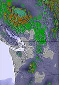 | 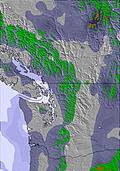 | 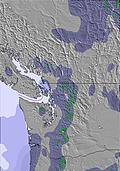 | 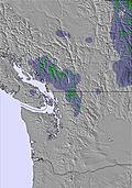 | 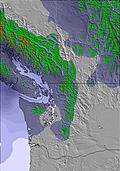 | 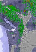 | |||||||||||
— | — | — | — | — | — | — | — | — | — | — | — | — | — | — | — | — | |
— | — | — | — | — | — | — | — | — | — | 1 | 1 | — | — | — | — | — | |
max °C | 20 | 18 | 21 | 25 | 20 | 25 | 28 | 24 | 23 | 25 | 20 | 21 | 23 | 19 | 20 | 23 | 21 |
min °C | 19 | 9 | 16 | 24 | 13 | 19 | 27 | 17 | 19 | 23 | 14 | 18 | 21 | 9 | 15 | 23 | 11 |
19 | 9 | 16 | 24 | 13 | 19 | 27 | 17 | 19 | 23 | 14 | 18 | 21 | 8 | 15 | 23 | 11 | |
27 | 63 | 33 | 23 | 48 | 29 | 27 | 57 | 44 | 43 | 78 | 40 | 27 | 60 | 32 | 24 | 60 | |
3150 | 3000 | 3100 | 3850 | 3800 | 3900 | 4300 | 4400 | 3850 | 3900 | 3650 | 3300 | 3300 | 2800 | 2950 | 3600 | 3300 | |
— | — | 4:56 | — | — | 4:56 | — | — | 4:56 | — | — | 4:56 | — | — | 4:56 | — | — | |
— | 9:24 | — | — | 9:24 | — | — | 9:25 | — | — | 9:25 | — | — | 9:27 | — | — | 9:27 | |
Go pro and carve into:
Avalanche information: Avalanche Canada
Latest snow reports near Tyax Lodge & Heliskiing:
| Top snow depth: | — |
|---|---|
| Bottom snow depth: | — |
| Fresh snowfall depth: | — |
| Last snowfall: | 6 Jun 2026 |
| Snow Alerts | Create Alert |
0.0 | Bluebird Powder days Fresh snow, mostly sunny, light wind. |
|---|---|
0.0 | Powder days Fresh snow, limited sun, any wind. |
0.0 | Bluebird days Average snow, mostly sunny, light wind. |
The above table gives the weather forecast for Tyax Lodge & Heliskiing at the specific elevation of 835 m. Our sophisticated weather models allow us to provide snow forecasts for the top, middle and bottom ski stations of Tyax Lodge & Heliskiing. To access the weather forecasts for the other elevations, use the tab navigation above the table. For a wider view of the weather, check out the Weather Map of Canada.
Click here to read further information on freezing levels and how we forecast our temperatures.
I just finished Steep Week with TLH. This was the most amazing trip of my life. Our guides (Cliff, Johnny, Eric) were superb. We experienced a combination of open steep alpine runs, tree runs, and everything in between. The expense of heli skiing is no joke, but TLH was worth every penny. I also found the unlimited vertical part of the package an indispensable part of the trip. We got lucky with weather and would have reached our max. by day 3. Because of the unlimited vert, we kept going without any worries of additional expense. Two thumbs, waaayyyy up!
Eric from United States writes:
I just finished Steep Week with TLH. This was the most amazing trip of my life. Our guides (Cliff, Johnny, Eric) were superb. We experienced a combination of open steep alpine runs, tree runs, and everything in between. The expense of heli skiing is no joke, but TLH was worth every penny. I also found the unlimited vertical part of the package an indispensable part of the trip. We got lucky with weather and would have reached our max. by day 3. Because of the unlimited vert, we kept going without any worries of additional expense. Two thumbs, waaayyyy up!
Click here to submit your own review of Tyax Lodge & Heliskiing


 Nearest