

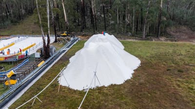
🇦🇺🇳🇿 Southern Hemisphere Weekly Snow Roundup #316
Weekly Snow News for the Southern Hemisphere, updated 28 May 2026: Cold temperatures, snowmaking and light snowfall raise optimism ahead of Australia and New Zealand’s 2026 ski season openings.

Next 3 days weather summary:Moderate rain (total 15.0mm), heaviest on Fri night. Warm (max 24°C on Fri afternoon, min 11°C on Thu night). Wind will be generally light. | Days 4-6 weather summary:Moderate rain (total 18.0mm), heaviest on Sun afternoon. Very mild (max 19°C on Sun afternoon, min 9°C on Sun night). Wind will be generally light. | ||||||||||||||||
Thu 28 | Friday 29 | Saturday 30 | Sunday 31 | Monday 1 | Tuesday 2 | ||||||||||||
PM | night | AM | PM | night | AM | PM | night | AM | PM | night | AM | PM | night | AM | PM | night | |
some clouds | clear | some clouds | some clouds | heavy rain | rain shwrs | clear | some clouds | light rain | risk thun- der | rain shwrs | rain shwrs | light rain | cloudy | cloudy | light rain | light rain | |
km/h | |||||||||||||||||
Snow map |  |  |  | 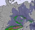 | 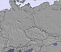 | 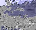 | |||||||||||
— | — | — | — | — | — | — | — | — | — | — | — | — | — | — | — | — | |
— | — | — | — | 13 | 1 | — | — | 1 | 6 | 2 | 2 | 2 | — | — | 2 | 3 | |
max °C | 19 | 15 | 21 | 24 | 21 | 19 | 21 | 16 | 16 | 19 | 14 | 16 | 16 | 15 | 14 | 14 | 13 |
min °C | 19 | 11 | 16 | 24 | 14 | 15 | 20 | 11 | 15 | 17 | 9 | 12 | 15 | 11 | 13 | 13 | 10 |
19 | 11 | 16 | 24 | 14 | 14 | 20 | 10 | 14 | 16 | 6 | 10 | 14 | 10 | 12 | 12 | 9 | |
30 | 44 | 42 | 45 | 79 | 66 | 58 | 72 | 73 | 91 | 92 | 66 | 73 | 81 | 81 | 92 | 94 | |
3500 | 3450 | 3650 | 3600 | 3350 | 3350 | 3550 | 3600 | 3150 | 3300 | 3100 | 3050 | 3100 | 3100 | 2950 | 3050 | 2700 | |
— | — | 5:18 | — | — | 5:18 | — | — | 5:16 | — | — | 5:16 | — | — | 5:15 | — | — | |
— | 9:25 | — | — | 9:28 | — | — | 9:29 | — | — | 9:30 | — | — | 9:30 | — | — | 9:31 | |
Latest snow reports near Winterberg:
| Top snow depth: | 0 cm |
|---|---|
| Bottom snow depth: | 0 cm |
| Fresh snowfall depth: | — |
| Last snowfall: | 12 May 2026 |
| Snow Alerts | Create Alert |
0.0 | Bluebird Powder days Fresh snow, mostly sunny, light wind. |
|---|---|
0.0 | Powder days Fresh snow, limited sun, any wind. |
0.0 | Bluebird days Average snow, mostly sunny, light wind. |
The above table gives the weather forecast for Winterberg at the specific elevation of 640 m. Our sophisticated weather models allow us to provide snow forecasts for the top, middle and bottom ski stations of Winterberg. To access the weather forecasts for the other elevations, use the tab navigation above the table. For a wider view of the weather, check out the Weather Map of Germany.
Click here to read further information on freezing levels and how we forecast our temperatures.
Overall 3.2 Based on 10 votes and 7 reviews
Winterberg is a completely different experience to anything that I have ever been to before. I have been skiing for 6 years and that has been at big alpine resorts (Garmisch-Partenkirchen) and Winterberg is a big down scale from that. I don't think it's quite as bad as some make it out to be but it is very small and it is a good place for beginners to learn and better than that if you live in the far south east of England it is closer to go to Winterberg rather than Scotland (so you can drive with help of a train or ferry). The trip on the other side is less than 5 hours. The only other thing is I recommend you don't drive through Essen as it's a log jam and go during the week (school holiday? so you can teach the kids) as during the weekend it's full of people from the Netherlands. Knowing a few words of German is a must as many don't speak any English. Finally, it's cheaper than any resort that I have seen of this size (Scotland) so it's good to learn because why pay for a big ski area pass if you're only going to use a few learner slopes. Whereas, in Winterberg, an adult day pass is 23 euros.
frazer attrill from United Kingdom writes:
Winterberg is a completely different experience to anything that I have ever been to before. I have been skiing for 6 years and that has been at big alpine resorts (Garmisch-Partenkirchen) and Winterberg is a big down scale from that. I don't think it's quite as bad as some make it out to be but it is very small and it is a good place for beginners to learn and better than that if you live in the far south east of England it is closer to go to Winterberg rather than Scotland (so you can drive with help of a train or ferry). The trip on the other side is less than 5 hours. The only other thing is I recommend you don't drive through Essen as it's a log jam and go during the week (school holiday? so you can teach the kids) as during the weekend it's full of people from the Netherlands. Knowing a few words of German is a must as many don't speak any English. Finally, it's cheaper than any resort that I have seen of this size (Scotland) so it's good to learn because why pay for a big ski area pass if you're only going to use a few learner slopes. Whereas, in Winterberg, an adult day pass is 23 euros.


 Nearest