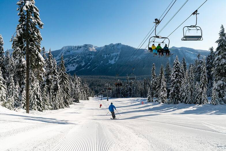


Portillo Re-Opens To Guests Arriving By Helicopter
Chile’s famous Portillo ski resort is reported to have re-opened to guests arriving by helicopter after being cut off by road for more than two weeks by over 6m/20 feet of snowfall.

Next 4 days weather summary:Mostly dry. Warm (max 21°C on Wed afternoon, min 7°C on Sun night). Winds decreasing (fresh winds from the N on Sun night, calm by Tue afternoon). | Days 5-7 weather summary:Mostly dry. Warm (max 21°C on Wed night, min 12°C on Fri night). Wind will be generally light. | |||||||||||||||
Monday 3 | Tuesday 4 | Wednesday 5 | Thursday 6 | Friday 7 | ||||||||||||
night | AM | PM | night | AM | PM | night | AM | PM | night | AM | PM | night | AM | PM | night | |
clear | clear | clear | clear | clear | clear | clear | clear | clear | clear | clear | clear | clear | clear | clear | clear | |
km/h | ||||||||||||||||
Snow map |  |  | 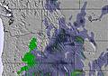 | 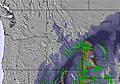 | 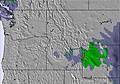 | 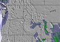 | ||||||||||
— | — | — | — | — | — | — | — | — | — | — | — | — | — | — | — | |
mm | — | — | — | — | — | — | — | — | — | — | — | — | — | — | — | — |
max °C | 8 | 13 | 15 | 16 | 18 | 20 | 19 | 20 | 21 | 21 | 19 | 21 | 20 | 16 | 17 | 16 |
min °C | 7 | 10 | 14 | 15 | 16 | 19 | 18 | 19 | 20 | 18 | 18 | 19 | 16 | 15 | 17 | 12 |
chill °C | 3 | 9 | 14 | 15 | 16 | 19 | 18 | 19 | 20 | 18 | 18 | 19 | 15 | 14 | 17 | 11 |
Humid % | 64 | 36 | 34 | 37 | 28 | 30 | 21 | 18 | 24 | 34 | 28 | 28 | 31 | 40 | 48 | 51 |
Freeze m | 3300 | 3650 | 3950 | 4100 | 4150 | 4400 | 4550 | 4650 | 4800 | 4800 | 4700 | 4800 | 4750 | 4400 | 4150 | 3950 |
— | 5:48 | — | — | 5:48 | — | — | 5:50 | — | — | 5:52 | — | — | 5:52 | — | — | |
— | — | — | 8:39 | — | — | 8:37 | — | — | 8:37 | — | — | 8:35 | — | — | 8:34 | |
Go pro and carve into:
Avalanche information: National Avalanche Center
Latest snow reports near The Summit at Snoqualmie:
| Top snow depth: | — |
|---|---|
| Bottom snow depth: | — |
| Fresh snowfall depth: | — |
| Last snowfall: | 6 Jun 2026 |
| Snow Alerts | Create Alert |
0.0 | Bluebird Powder days Fresh snow, mostly sunny, light wind. |
|---|---|
0.0 | Powder days Fresh snow, limited sun, any wind. |
0.0 | Bluebird days Average snow, mostly sunny, light wind. |

The above table gives the weather forecast for The Summit at Snoqualmie at the specific elevation of 1311 m. Our sophisticated weather models allow us to provide snow forecasts for the top, middle and bottom ski stations of The Summit at Snoqualmie. To access the weather forecasts for the other elevations, use the tab navigation above the table. For a wider view of the weather, check out the Weather Map of United States.
Click here to read further information on freezing levels and how we forecast our temperatures.
Overall 1.0 Based on 1 vote and 5 reviews
Warning: the map location and forecasts are not correct for this listing for The Summit at Snoqualmie. For some reason, this shows it on the south side of Cougar Mountain, nowhere near Snoqualmie Pass. The correct one is snow-forecast.com/resorts/Snoqualmie/6day/mid [note from the editor: the following text can be seen on the Resort Guide page: This is a duplicated entry. See Summit at Snoqualime pages.)
Cory from United States writes:
Warning: the map location and forecasts are not correct for this listing for The Summit at Snoqualmie.
For some reason, this shows it on the south side of Cougar Mountain, nowhere near Snoqualmie Pass.
The correct one is snow-forecast.com/resorts/Snoqualmie/6day/mid
[note from the editor: the following text can be seen on the Resort Guide page: This is a duplicated entry. See Summit at Snoqualime pages.)
Read 4 more reviews of The Summit at Snoqualmie or submit your own


 Nearest