

Global Weekly Snow Roundup #318
Weekly Snow News for the world, updated 11 June 2026: Australia's season begins, Val d’Isère reopens and major snowfall is forecast for the Andes.

Next 4 days weather summary:Mostly dry. Very mild (max 12°C on Sat afternoon, min 7°C on Sun night). Wind will be generally light. | Days 5-7 weather summary:Mostly dry. Very mild (max 13°C on Thu afternoon, min 7°C on Mon night). Wind will be generally light. | |||||||||||||||
Saturday 13 | Sunday 14 | Monday 15 | Tuesday 16 | Wednesday 17 | ||||||||||||
night | AM | PM | night | AM | PM | night | AM | PM | night | AM | PM | night | AM | PM | night | |
clear | clear | some clouds | clear | some clouds | some clouds | clear | clear | clear | clear | clear | clear | clear | clear | clear | clear | |
km/h | ||||||||||||||||
Snow map |  |  |  |  |  |  | ||||||||||
— | — | — | — | — | — | — | — | — | — | — | — | — | — | — | — | |
— | — | — | — | — | — | — | — | — | — | — | — | — | — | — | — | |
max °C | 8 | 10 | 12 | 11 | 9 | 9 | 9 | 8 | 9 | 8 | 9 | 10 | 9 | 10 | 12 | 11 |
min °C | 8 | 9 | 11 | 9 | 9 | 9 | 7 | 7 | 9 | 7 | 8 | 9 | 8 | 9 | 11 | 10 |
5 | 7 | 10 | 9 | 8 | 8 | 6 | 5 | 8 | 6 | 8 | 8 | 7 | 9 | 11 | 10 | |
44 | 27 | 33 | 31 | 22 | 40 | 37 | 40 | 53 | 35 | 38 | 59 | 55 | 54 | 62 | 60 | |
4100 | 4150 | 4150 | 4100 | 3950 | 3750 | 3800 | 3650 | 3600 | 3800 | 3800 | 3800 | 4000 | 4050 | 4150 | 4250 | |
— | 5:45 | — | — | 5:45 | — | — | 5:45 | — | — | 5:45 | — | — | 5:45 | — | — | |
— | — | — | 9:22 | — | — | 9:22 | — | — | 9:23 | — | — | 9:23 | — | — | 9:24 | |
Go pro and carve into:
Avalanche information: European Avalanche Warning Services (EAWS)
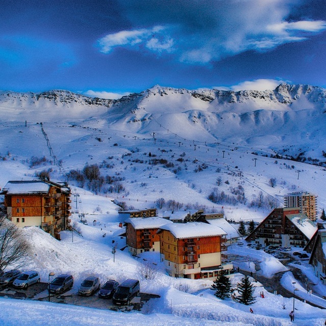
Latest snow reports near Saint François Longchamp:
| Top snow depth: | — |
|---|---|
| Bottom snow depth: | — |
| Fresh snowfall depth: | — |
| Last snowfall: | 18 May 2026 |
| Snow Alerts | Create Alert |
0.0 | Bluebird Powder days Fresh snow, mostly sunny, light wind. |
|---|---|
0.1 | Powder days Fresh snow, limited sun, any wind. |
0.0 | Bluebird days Average snow, mostly sunny, light wind. |
The above table gives the weather forecast for Saint François Longchamp at the specific elevation of 2550 m. Our sophisticated weather models allow us to provide snow forecasts for the top, middle and bottom ski stations of Saint François Longchamp. To access the weather forecasts for the other elevations, use the tab navigation above the table. For a wider view of the weather, check out the Weather Map of France.
Click here to read further information on freezing levels and how we forecast our temperatures.
Resort name is also written as Saint Francois Longchamp.
Overall 4.4 Based on 7 votes and 5 reviews
I am fed up with so called experts running down resorts. I am 57 years old, have been skiing since I was 12 and have skied in excess of 35 resorts and Saint Francois Longchamp is very good. I am a qualified instructor in many aspects of the sport. Another reviewer needs to decide if the black leading off to the left, from the Luziere chair, just after a fresh fall, is challenging enough or they would rather have a top class night club where he can go on the piss until 2.00am. Make your mind up! SFL and the Grand Domaine are very good; it is good for all standards. Skiing isn't about screaming down a few slopes as fast as you can but is an experience of the environment and the joy of sliding in control and enjoying yourself. I feel that the facilities for absolute beginners, although adequate, could improve. However, once you have mastered the basics the next step at SFL is very good. Wide green slopes enabling travel and technique improvement. High blues and a gentle decent are there if you want it. There are a couple or three of the long serving instructors who need to update their teaching techniques to take into account the change that has happened with the advances in equipment. For those who have skied maybe one or two weeks, before you can enjoy the Grand Domaine even further, improve your confidence and ability plus enjoyment with 'you' time on the snow. The dammers at SFL work very hard to prepare your slopes to their best and are better prepared than the Valmorel side of the mountain. If your idea of skiing is going on the piss until 2.00am or until you can't see, then this is not the resort for you. If you want to enjoy mountains, mountain life, enjoying the resort ambiance, developing your skiing and improving it and travelling in an area of 165 kilometres and what it offers then it is definitely for you. I can drive to pretty much anywhere from where I live in France but I will drive to SFL 1650 on Saturday.
Steve Taylor from France writes:
I am fed up with so called experts running down resorts. I am 57 years old, have been skiing since I was 12 and have skied in excess of 35 resorts and Saint Francois Longchamp is very good. I am a qualified instructor in many aspects of the sport. Another reviewer needs to decide if the black leading off to the left, from the Luziere chair, just after a fresh fall, is challenging enough or they would rather have a top class night club where he can go on the piss until 2.00am. Make your mind up!
SFL and the Grand Domaine are very good; it is good for all standards. Skiing isn't about screaming down a few slopes as fast as you can but is an experience of the environment and the joy of sliding in control and enjoying yourself. I feel that the facilities for absolute beginners, although adequate, could improve. However, once you have mastered the basics the next step at SFL is very good. Wide green slopes enabling travel and technique improvement. High blues and a gentle decent are there if you want it. There are a couple or three of the long serving instructors who need to update their teaching techniques to take into account the change that has happened with the advances in equipment. For those who have skied maybe one or two weeks, before you can enjoy the Grand Domaine even further, improve your confidence and ability plus enjoyment with 'you' time on the snow.
The dammers at SFL work very hard to prepare your slopes to their best and are better prepared than the Valmorel side of the mountain.
If your idea of skiing is going on the piss until 2.00am or until you can't see, then this is not the resort for you. If you want to enjoy mountains, mountain life, enjoying the resort ambiance, developing your skiing and improving it and travelling in an area of 165 kilometres and what it offers then it is definitely for you. I can drive to pretty much anywhere from where I live in France but I will drive to SFL 1650 on Saturday.
Read 4 more reviews of Saint François Longchamp or submit your own


 Nearest