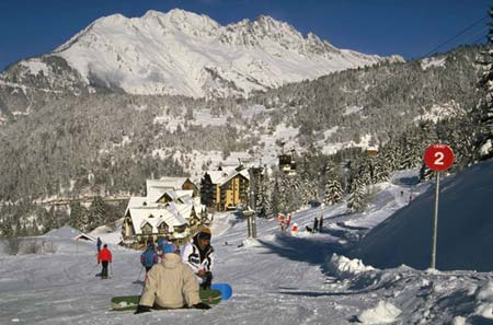


Portillo Storm Snowfall Total Passes 5m / 17 Feet
A snow storm that has now continued for nine days has taken Chilean ski resort Portillo to a snowfall total of 5.2 metres (17 feet) so far, with more snow forecast.

Next 3 days weather summary:Light rain (total 4.0mm), mostly falling on Sun morning. Very mild (max 13°C on Tue afternoon, min 4°C on Sun morning). Wind will be generally light. | Days 4-6 weather summary:Mostly dry. Very mild (max 17°C on Fri afternoon, min 11°C on Wed morning). Wind will be generally light. | |||||||||||||||||
Sunday 26 | Monday 27 | Tuesday 28 | Wednesday 29 | Thursday 30 | Friday 31 | |||||||||||||
AM | PM | night | AM | PM | night | AM | PM | night | AM | PM | night | AM | PM | night | AM | PM | night | |
light rain | rain shwrs | some clouds | clear | clear | clear | clear | clear | clear | clear | clear | clear | clear | some clouds | clear | clear | some clouds | some clouds | |
km/h | ||||||||||||||||||
Snow map |  |  |  |  |  |  | ||||||||||||
— | — | — | — | — | — | — | — | — | — | — | — | — | — | — | — | — | — | |
mm | 2 | 2 | — | — | — | — | — | — | — | — | — | — | — | — | — | — | — | — |
max °C | 4 | 5 | 7 | 10 | 12 | 12 | 12 | 13 | 12 | 11 | 14 | 14 | 14 | 16 | 16 | 16 | 17 | 15 |
min °C | 4 | 4 | 5 | 8 | 11 | 12 | 11 | 12 | 11 | 11 | 13 | 13 | 13 | 15 | 14 | 14 | 17 | 14 |
chill °C | 4 | 1 | 2 | 6 | 10 | 11 | 11 | 12 | 11 | 10 | 13 | 12 | 13 | 15 | 14 | 14 | 17 | 12 |
Humid % | 89 | 86 | 86 | 27 | 39 | 32 | 58 | 74 | 65 | 55 | 45 | 38 | 40 | 40 | 43 | 34 | 41 | 34 |
Freeze m | 3450 | 3600 | 3700 | 4600 | 4750 | 4950 | 4600 | 4650 | 4550 | 4450 | 4750 | 4750 | 4700 | 4850 | 4750 | 4750 | 4900 | 4900 |
6:13 | — | — | 6:13 | — | — | 6:15 | — | — | 6:16 | — | — | 6:16 | — | — | 6:18 | — | — | |
— | — | 9:09 | — | — | 9:08 | — | — | 9:07 | — | — | 9:07 | — | — | 9:05 | — | — | 9:04 | |
Go pro and carve into:
Avalanche information: European Avalanche Warning Services (EAWS)
Latest snow reports near Oz en Oisans:
| Top snow depth: | — |
|---|---|
| Bottom snow depth: | — |
| Fresh snowfall depth: | — |
| Last snowfall: | 16 May 2026 |
| Snow Alerts | Create Alert |
0.0 | Bluebird Powder days Fresh snow, mostly sunny, light wind. |
|---|---|
0.1 | Powder days Fresh snow, limited sun, any wind. |
0.0 | Bluebird days Average snow, mostly sunny, light wind. |
The above table gives the weather forecast for Oz en Oisans at the specific elevation of 2800 m. Our sophisticated weather models allow us to provide snow forecasts for the top, middle and bottom ski stations of Oz en Oisans. To access the weather forecasts for the other elevations, use the tab navigation above the table. For a wider view of the weather, check out the Weather Map of France.
Click here to read further information on freezing levels and how we forecast our temperatures.
Overall 4.3 Based on 15 votes and 13 reviews
Stayed with family for the 19/20 new year week. Good snow coverage and sunny every day but mild temperatures meant icy lower runs back to Oz with moguled runs by lunchtime. It's generally quiet in the evenings. Not a lot else to do in resort. There's only one supermarket which is small, poorly stocked and expensive, even for Alps standards. You'll be lucky to find bread and milk after 5.30pm at peak times although the bakery at the other end of town sometimes still has some. The lift queues on the Oz side were usually much quieter than Alpe d' Huez. We sometimes queued more than 20mins for the main lifts there. Auris also quieter with plenty of nice runs. You'll have to be heading back by 3.30.
Simon from United Kingdom writes:
Stayed with family for the 19/20 new year week. Good snow coverage and sunny every day but mild temperatures meant icy lower runs back to Oz with moguled runs by lunchtime.
It's generally quiet in the evenings. Not a lot else to do in resort.
There's only one supermarket which is small, poorly stocked and expensive, even for Alps standards. You'll be lucky to find bread and milk after 5.30pm at peak times although the bakery at the other end of town sometimes still has some.
The lift queues on the Oz side were usually much quieter than Alpe d' Huez. We sometimes queued more than 20mins for the main lifts there. Auris also quieter with plenty of nice runs. You'll have to be heading back by 3.30.


 Nearest