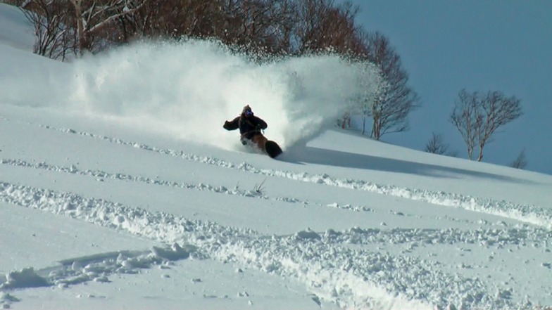


Niseko Announce New Gondola
Niseko Village has confirmed a major lift expansion that will reshape access on the southern side of the Niseko United ski area, with a new gondola scheduled to open next winter and a second stage planned for 2027–28.

Next 4 days weather summary:Mostly dry. Warm (max 25°C on Thu morning, min 16°C on Mon night). Wind will be generally light. | Days 5-7 weather summary:Moderate rain (total 12.0mm), heaviest on Sat afternoon. Warm (max 25°C on Fri morning, min 19°C on Sat night). Wind will be generally light. | |||||||||||||||
Tuesday 4 | Wednesday 5 | Thursday 6 | Friday 7 | Saturday 8 | ||||||||||||
night | AM | PM | night | AM | PM | night | AM | PM | night | AM | PM | night | AM | PM | night | |
clear | clear | clear | clear | clear | clear | some clouds | some clouds | clear | some clouds | clear | clear | clear | rain shwrs | t-storm risk | light rain | |
km/h | ||||||||||||||||
Snow map |  |  |  | 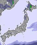 | 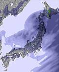 | 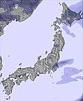 | ||||||||||
— | — | — | — | — | — | — | — | — | — | — | — | — | — | — | — | |
mm | — | — | — | — | — | — | — | — | — | — | — | — | — | 1 | 3 | 3 |
max °C | 17 | 22 | 22 | 18 | 24 | 24 | 19 | 25 | 24 | 21 | 25 | 25 | 21 | 23 | 22 | 19 |
min °C | 16 | 20 | 20 | 17 | 22 | 22 | 19 | 23 | 22 | 20 | 23 | 23 | 20 | 22 | 20 | 19 |
chill °C | 16 | 20 | 20 | 17 | 22 | 22 | 19 | 23 | 22 | 20 | 23 | 23 | 20 | 22 | 20 | 19 |
Humid % | 64 | 46 | 38 | 59 | 43 | 36 | 55 | 46 | 47 | 65 | 50 | 59 | 88 | 85 | 89 | 96 |
Freeze m | 5250 | 5300 | 5500 | 5550 | 5550 | 5550 | 5450 | 5350 | 5400 | 5350 | 5300 | 5350 | 5200 | 4950 | 4800 | 4550 |
— | 4:30 | — | — | 4:31 | — | — | 4:31 | — | — | 4:33 | — | — | 4:33 | — | — | |
— | — | 6:54 | — | — | 6:53 | — | — | 6:52 | — | — | 6:51 | — | — | 6:50 | — | |
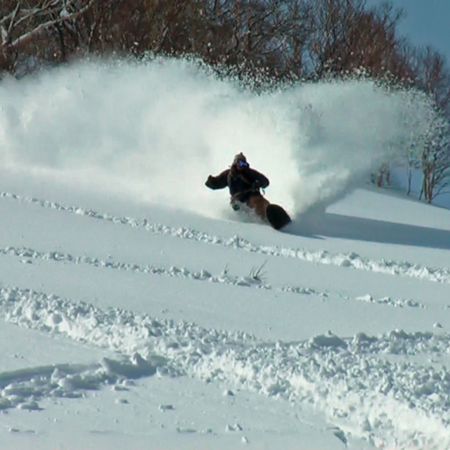
Go pro and carve into:
Avalanche information: Japan Avalanche Network
Latest snow reports near Niseko Grand Hirafu:
| Top snow depth: | 0 cm |
|---|---|
| Bottom snow depth: | 0 cm |
| Fresh snowfall depth: | — |
| Last snowfall: | 4 May 2026 |
| Snow Alerts | Create Alert |
0.0 | Bluebird Powder days Fresh snow, mostly sunny, light wind. |
|---|---|
0.0 | Powder days Fresh snow, limited sun, any wind. |
0.0 | Bluebird days Average snow, mostly sunny, light wind. |
The above table gives the weather forecast for Niseko Grand Hirafu at the specific elevation of 706 m. Our sophisticated weather models allow us to provide snow forecasts for the top, middle and bottom ski stations of Niseko Grand Hirafu. To access the weather forecasts for the other elevations, use the tab navigation above the table. For a wider view of the weather, check out the Weather Map of Japan.
Click here to read further information on freezing levels and how we forecast our temperatures.
Resort name is also written as Niseko Hirafu.
Overall 3.9 Based on 81 votes and 120 reviews
Definitely spring skiing conditions now. Only top skiing well atm, but that's becoming heavier too. Freeze thaw, but hey it's still fun and besides, think of all of the many worse things that you could be doing.
Nigel Wright from Australia writes:
Definitely spring skiing conditions now. Only top skiing well atm, but that's becoming heavier too. Freeze thaw, but hey it's still fun and besides, think of all of the many worse things that you could be doing.
Read 119 more reviews of Niseko Grand Hirafu or submit your own


 Nearest