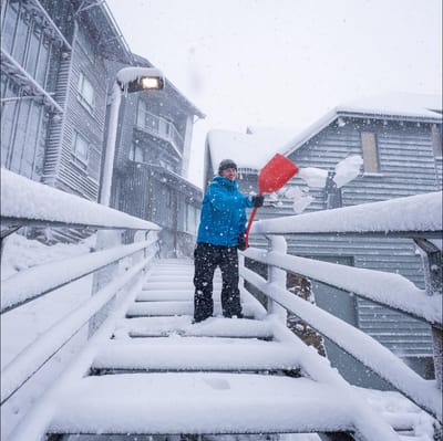
"March Madness" As Snowfall Hits Australia In Early Autumn
Winter made an early-season entrance in Australia overnight, with a polar blast from the Antarctic dumping up to 15cm of fresh snow on the slopes as temperatures tumbled to around -2.C.


Métabief Weather (Next 3 days): The snow forecast for Métabief is: A moderate fall of snow, heaviest on Mon night. Temperatures will be below freezing (max -2°C on Mon afternoon, min -6°C on Mon night). Winds increasing (light winds from the N on Tue night, strong winds from the ENE by Wed night).
Métabief Weather (Days 4-6): Mostly dry. Freeze-thaw conditions (max 10°C on Sat night, min -5°C on Thu morning). Winds decreasing (strong winds from the ENE on Thu morning, calm by Fri night).
| Resort | Snow Depth | Temp. (°C) | Wind (km/h) | Weather | ||
|---|---|---|---|---|---|---|
| Top Lift: | -3 | |||||
| Middle Lift: | -1 | |||||
| Bottom Lift: | 2 |

Monday 30 | Tuesday 31 | Wednesday 1 | Thursday 2 | Friday 3 | Saturday 4 | |||||||||||||
AM | PM | night | AM | PM | night | AM | PM | night | AM | PM | night | AM | PM | night | AM | PM | night | |
light snow | light snow | light snow | light snow | light snow | light snow | light snow | snow shwrs | light snow | light snow | cloudy | clear | clear | some clouds | some clouds | clear | clear | clear | |
km/h | ||||||||||||||||||
Snow map |  |  |  |  |  |  | ||||||||||||
1 | 1 | 5 | — | — | 2 | — | 1 | — | — | — | — | — | — | — | — | — | — | |
— | — | — | — | — | — | — | — | — | — | — | — | — | — | — | — | — | — | |
max °C | -3 | -2 | -2 | -6 | -5 | -3 | -5 | -4 | -4 | -4 | -1 | 0 | 0 | 3 | 5 | 6 | 8 | 10 |
min °C | -3 | -3 | -6 | -6 | -5 | -5 | -5 | -4 | -5 | -5 | -3 | 0 | 0 | 2 | 3 | 6 | 7 | 8 |
-11 | -9 | -14 | -14 | -11 | -13 | -13 | -12 | -15 | -14 | -11 | -7 | -5 | 0 | 3 | 5 | 6 | 6 | |
100 | 98 | 96 | 96 | 90 | 99 | 98 | 93 | 98 | 99 | 97 | 70 | 72 | 78 | 49 | 31 | 62 | 40 | |
1050 | 1100 | 750 | 650 | 900 | 850 | 850 | 950 | 650 | 900 | 1250 | 1550 | 1550 | 2150 | 2350 | 3000 | 3100 | 3150 | |
7:18 | — | — | 7:16 | — | — | 7:15 | — | — | 7:13 | — | — | 7:11 | — | — | 7:09 | — | — | |
— | — | 8:00 | — | — | 8:00 | — | — | 8:01 | — | — | 8:04 | — | — | 8:05 | — | — | 8:06 | |
A moderate fall of snow, heaviest on Mon night. Temperatures will be below freezing (max -2°C on Mon afternoon, min -6°C on Mon night). Winds increasing (light winds from the N on Tue night, strong winds from the ENE by Wed night).
Mostly dry. Freeze-thaw conditions (max 10°C on Sat night, min -5°C on Thu morning). Winds decreasing (strong winds from the ENE on Thu morning, calm by Fri night).
Latest snow reports near Métabief:
Drizzle reported from Les Eplatures Airport at 1011 metres elevation only 2 kms S of La Chaux-de-Fonds but it is forecast cold enough for snow at the ski area from La Chaux-de-Fonds
Light snow reported from Les Eplatures Airport at 1011 metres elevation only 2 kms S of La Chaux-de-Fonds Ski Resort from La Chaux-de-Fonds
| Top snow depth: | — |
|---|---|
| Bottom snow depth: | — |
| Fresh snowfall depth: | 4 cm |
| Last snowfall: | 28 Mar 2026 |
| Snow Alerts | Create Alert |
0.2 | Bluebird Powder days Fresh snow, mostly sunny, light wind. |
|---|---|
1.2 | Powder days Fresh snow, limited sun, any wind. |
0.4 | Bluebird days Average snow, mostly sunny, light wind. |
The above table gives the weather forecast for Métabief at the specific elevation of 1463 m. Our sophisticated weather models allow us to provide snow forecasts for the top, middle and bottom ski stations of Métabief. To access the weather forecasts for the other elevations, use the tab navigation above the table. For a wider view of the weather, check out the Weather Map of France.
Click here to read further information on freezing levels and how we forecast our temperatures.
Resort name is also written as Metabief.
Overall 3.9 Based on 6 votes and 2 reviews
Métabief is a great little family resort. Most of the runs are blues and reds with some long greens for beginners. The lifts are pretty good too, although there can be queues at weekends and French school holidays. The main drawback is the snow record at Métabief, which has been extremely patchy for the last ten years. Who says global warming is hype...
CW from United Kingdom writes:
Métabief is a great little family resort. Most of the runs are blues and reds with some long greens for beginners. The lifts are pretty good too, although there can be queues at weekends and French school holidays. The main drawback is the snow record at Métabief, which has been extremely patchy for the last ten years. Who says global warming is hype...


 Nearest